Ragan Topo Map Wyoming
To zoom in, hover over the map of Ragan
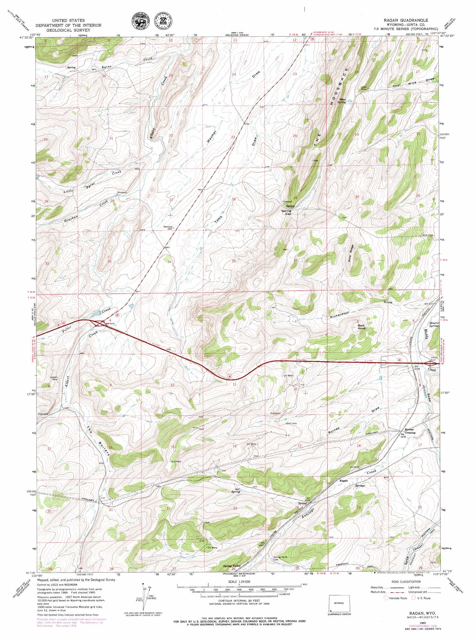
USGS Topo Quad 41110c6 - 1:24,000 scale
| Topo Map Name: | Ragan |
| USGS Topo Quad ID: | 41110c6 |
| Print Size: | ca. 21 1/4" wide x 27" high |
| Southeast Coordinates: | 41.25° N latitude / 110.625° W longitude |
| Map Center Coordinates: | 41.3125° N latitude / 110.6875° W longitude |
| U.S. State: | WY |
| Filename: | o41110c6.jpg |
| Download Map JPG Image: | Ragan topo map 1:24,000 scale |
| Map Type: | Topographic |
| Topo Series: | 7.5´ |
| Map Scale: | 1:24,000 |
| Source of Map Images: | United States Geological Survey (USGS) |
| Alternate Map Versions: |
Ragan WY 1965, updated 1968 Download PDF Buy paper map Ragan WY 1965, updated 1979 Download PDF Buy paper map Ragan WY 1965, updated 1979 Download PDF Buy paper map Ragan WY 2012 Download PDF Buy paper map Ragan WY 2015 Download PDF Buy paper map |
1:24,000 Topo Quads surrounding Ragan
Sawtooth Mountain |
Bell Butte |
Elkol Sw |
Cumberland Gap |
Mulkay Spring |
Three Forks |
Little Dee Creek |
Meadow Draw |
Bridger |
Carter |
Evanston |
Guild Hollow |
Ragan |
Leroy |
Fort Bridger |
Millis |
Sulphur Creek Reservoir |
Piedmont Reservoir |
Hague Creek |
Robertson |
Myers Reservoir |
Pine Knoll |
Moslander Reservoir |
Meeks Cabin Reservoir |
Buck Fever Ridge |
> Back to 41110a1 at 1:100,000 scale
> Back to 41110a1 at 1:250,000 scale
> Back to U.S. Topo Maps home
Ragan topo map: Gazetteer
Ragan: Gaps
Spring Gap elevation 2133m 6998′Ragan: Mines
Jager Oil Prospect elevation 2217m 7273′Jakes Mine elevation 2159m 7083′
Junction Mine elevation 2140m 7020′
Kendall Mine elevation 2155m 7070′
Lazeart Mine elevation 2140m 7020′
Lezear Opening Mine elevation 2195m 7201′
Richardson Mine elevation 2221m 7286′
Ragan: Populated Places
Byrnes Crossing elevation 2083m 6833′Ragan: Ridges
Pine Ridge elevation 2259m 7411′The Hogsback elevation 2281m 7483′
Ragan: Springs
Mine Spring elevation 2182m 7158′Mineral Springs elevation 2051m 6729′
Ragan: Streams
Antelope Creek elevation 2072m 6797′Byrne Creek elevation 2059m 6755′
Felter Creek elevation 2092m 6863′
Hinshaw Creek elevation 2077m 6814′
Little Byrne Creek elevation 2074m 6804′
Ragan: Summits
Bald Knoll elevation 2205m 7234′Ragan: Valleys
Byrnes Draw elevation 2074m 6804′Richardson Draw elevation 2055m 6742′
Soda Hollow elevation 2061m 6761′
Ragan digital topo map on disk
Buy this Ragan topo map showing relief, roads, GPS coordinates and other geographical features, as a high-resolution digital map file on DVD: