Peterson Topo Map Utah
To zoom in, hover over the map of Peterson
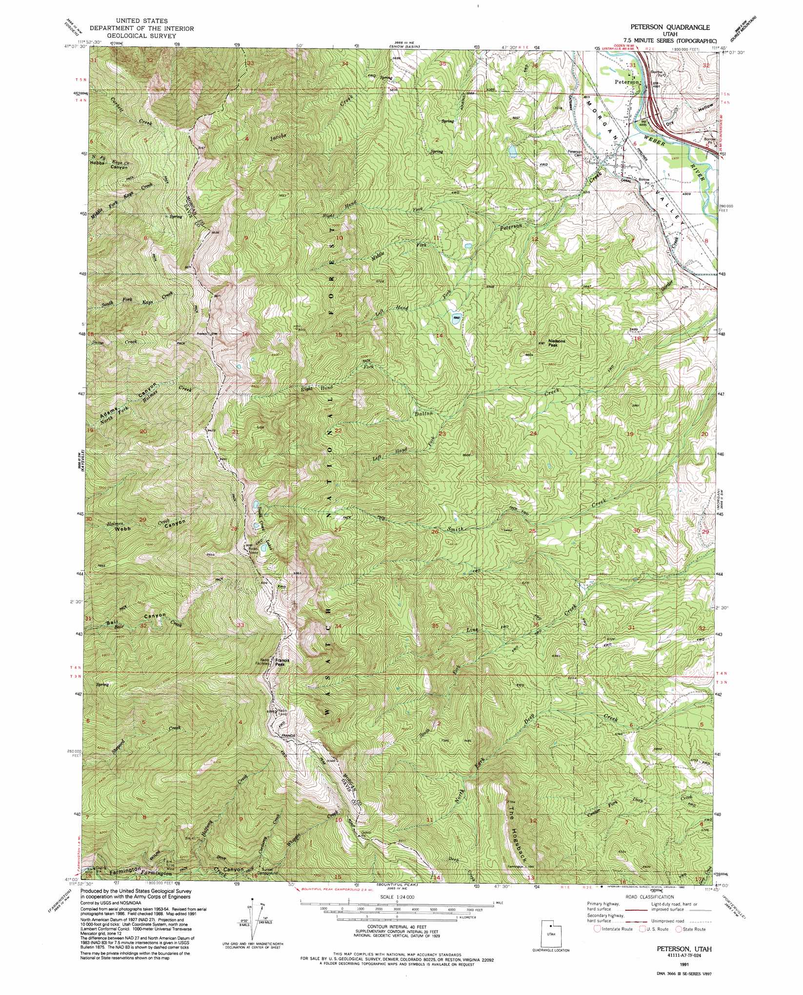
USGS Topo Quad 41111a7 - 1:24,000 scale
| Topo Map Name: | Peterson |
| USGS Topo Quad ID: | 41111a7 |
| Print Size: | ca. 21 1/4" wide x 27" high |
| Southeast Coordinates: | 41° N latitude / 111.75° W longitude |
| Map Center Coordinates: | 41.0625° N latitude / 111.8125° W longitude |
| U.S. State: | UT |
| Filename: | o41111a7.jpg |
| Download Map JPG Image: | Peterson topo map 1:24,000 scale |
| Map Type: | Topographic |
| Topo Series: | 7.5´ |
| Map Scale: | 1:24,000 |
| Source of Map Images: | United States Geological Survey (USGS) |
| Alternate Map Versions: |
Peterson UT 1955, updated 1956 Download PDF Buy paper map Peterson UT 1955, updated 1965 Download PDF Buy paper map Peterson UT 1955, updated 1970 Download PDF Buy paper map Peterson UT 1955, updated 1978 Download PDF Buy paper map Peterson UT 1955, updated 1985 Download PDF Buy paper map Peterson UT 1991, updated 1992 Download PDF Buy paper map Peterson UT 1998, updated 2000 Download PDF Buy paper map Peterson UT 2011 Download PDF Buy paper map Peterson UT 2014 Download PDF Buy paper map |
| FStopo: | US Forest Service topo Peterson is available: Download FStopo PDF Download FStopo TIF |
1:24,000 Topo Quads surrounding Peterson
Plain City |
North Ogden |
Huntsville |
Browns Hole |
Causey Dam |
Roy |
Ogden |
Snow Basin |
Durst Mountain |
Bybee Knoll |
Clearfield |
Kaysville |
Peterson |
Morgan |
Devils Slide |
Saltair Ne |
Farmington |
Bountiful Peak |
Porterville |
East Canyon Reservoir |
Saltair |
Salt Lake City North |
Fort Douglas |
Mountain Dell |
Big Dutch Hollow |
> Back to 41111a1 at 1:100,000 scale
> Back to 41110a1 at 1:250,000 scale
> Back to U.S. Topo Maps home
Peterson topo map: Gazetteer
Peterson: Airports
Francis Peak Heliport elevation 2883m 9458′Peterson: Canals
Gateway Canal elevation 1523m 4996′Peterson: Lakes
Smith Creek Lakes elevation 2680m 8792′Peterson: Populated Places
Peterson elevation 1489m 4885′Peterson: Streams
Corduroy Creek elevation 1829m 6000′Enterprise Slough elevation 1497m 4911′
Gorder Creek elevation 1505m 4937′
Halfway Creek elevation 1720m 5643′
Left Hand Fork Dalton Creek elevation 1863m 6112′
Left Hand Fork Peterson Creek elevation 1636m 5367′
Middle Fork Peterson Creek elevation 1708m 5603′
Morris Creek elevation 1811m 5941′
Peterson Creek elevation 1489m 4885′
Right Hand Fork Dalton Creek elevation 1922m 6305′
Right Hand Fork Peterson Creek elevation 1636m 5367′
South Fork Line Creek elevation 1833m 6013′
Peterson: Summits
Francis Peak elevation 2904m 9527′Nielsons Peak elevation 1883m 6177′
Thurston Peak elevation 2954m 9691′
Peterson: Valleys
Dry Hollow elevation 1499m 4917′Peterson digital topo map on disk
Buy this Peterson topo map showing relief, roads, GPS coordinates and other geographical features, as a high-resolution digital map file on DVD: