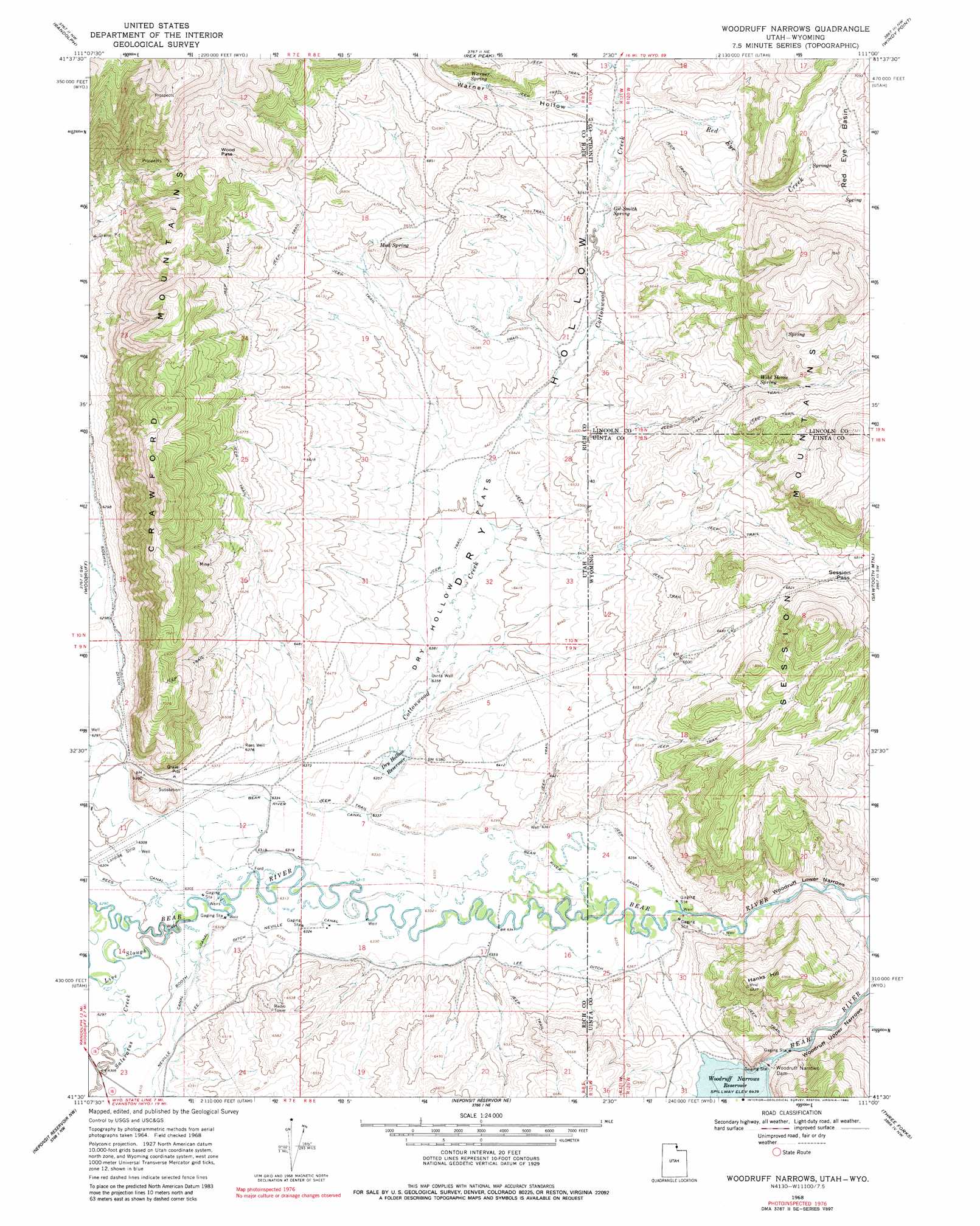
Woodruff Narrows Topo Map Utah
To zoom in, hover over the map of Woodruff Narrows
USGS Topo Quad 41111e1 - 1:24,000 scale
| Topo Map Name: | Woodruff Narrows |
| USGS Topo Quad ID: | 41111e1 |
| Print Size: | ca. 21 1/4" wide x 27" high |
| Southeast Coordinates: | 41.5° N latitude / 111° W longitude |
| Map Center Coordinates: | 41.5625° N latitude / 111.0625° W longitude |
| U.S. States: | UT, WY |
| Filename: | o41111e1.jpg |
| Download Map JPG Image: | Woodruff Narrows topo map 1:24,000 scale |
| Map Type: | Topographic |
| Topo Series: | 7.5´ |
| Map Scale: | 1:24,000 |
| Source of Map Images: | United States Geological Survey (USGS) |
| Alternate Map Versions: |
Woodruff Narrows WY 1968, updated 1971 Download PDF Buy paper map Woodruff Narrows WY 1968, updated 1980 Download PDF Buy paper map Woodruff Narrows WY 1968, updated 1980 Download PDF Buy paper map Woodruff Narrows WY 2011 Download PDF Buy paper map Woodruff Narrows WY 2012 Download PDF Buy paper map Woodruff Narrows WY 2015 Download PDF Buy paper map |
1:24,000 Topo Quads surrounding Woodruff Narrows
Laketown |
Sage Creek |
Leefe |
Sage |
Nugget |
Old Canyon |
Randolph |
Rex Peak |
Windy Point |
Bell Butte Ne |
Birch Creek Reservoirs |
Woodruff |
Woodruff Narrows |
Sawtooth Mountain |
Bell Butte |
Meachum Ridge |
Neponset Reservoir Nw |
Neponset Reservoir Ne |
Three Forks |
Little Dee Creek |
Peck Canyon |
Mckay Hollow |
Murphy Ridge |
Evanston |
Guild Hollow |
> Back to 41111e1 at 1:100,000 scale
> Back to 41110a1 at 1:250,000 scale
> Back to U.S. Topo Maps home
Woodruff Narrows topo map: Gazetteer
Woodruff Narrows: Basins
Red Eye Basin elevation 2155m 7070′Woodruff Narrows: Canals
Bear River Canal elevation 1936m 6351′Bear River Canal elevation 1933m 6341′
Booth Canal elevation 1925m 6315′
Lee Ditch elevation 1937m 6354′
Lee Ditch elevation 1937m 6354′
Neville Canal elevation 1928m 6325′
Rees Canal elevation 1922m 6305′
Sidehill Ditch elevation 1919m 6295′
Woodruff Narrows: Dams
Woodruff Narrows Dam elevation 1956m 6417′Woodruff Narrows Dam elevation 1964m 6443′
Woodruff Narrows: Flats
Dry Hollow Flats elevation 1950m 6397′Woodruff Narrows: Gaps
Session Pass elevation 2072m 6797′Wood Pass elevation 2146m 7040′
Woodruff Lower Narrows elevation 1943m 6374′
Woodruff Upper Narrows elevation 1951m 6400′
Woodruff Narrows: Guts
Live Slough elevation 1920m 6299′Woodruff Narrows: Ranges
Session Mountains elevation 2081m 6827′Woodruff Narrows: Reservoirs
Dry Hollow Reservoir elevation 1937m 6354′Woodruff Narrows Reservoir elevation 1964m 6443′
Woodruff Narrows: Springs
Gil Smith Spring elevation 1992m 6535′Mud Spring elevation 2018m 6620′
Warner Spring elevation 2055m 6742′
Wild Horse Spring elevation 2059m 6755′
Woodruff Narrows: Streams
Cottonwood Creek elevation 1936m 6351′Cottonwood Creek elevation 1936m 6351′
Red Eye Creek elevation 1999m 6558′
Saleratus Creek elevation 1920m 6299′
Woodruff Narrows: Summits
Hanks Hill elevation 2110m 6922′Woodruff Narrows: Valleys
Dry Hollow elevation 1931m 6335′Dry Hollow elevation 1936m 6351′
Warner Hollow elevation 2002m 6568′
Woodruff Narrows: Wells
Rees Well elevation 1945m 6381′Uinta Well elevation 1939m 6361′
Woodruff Narrows digital topo map on disk
Buy this Woodruff Narrows topo map showing relief, roads, GPS coordinates and other geographical features, as a high-resolution digital map file on DVD: