Woodruff Topo Map Utah
To zoom in, hover over the map of Woodruff
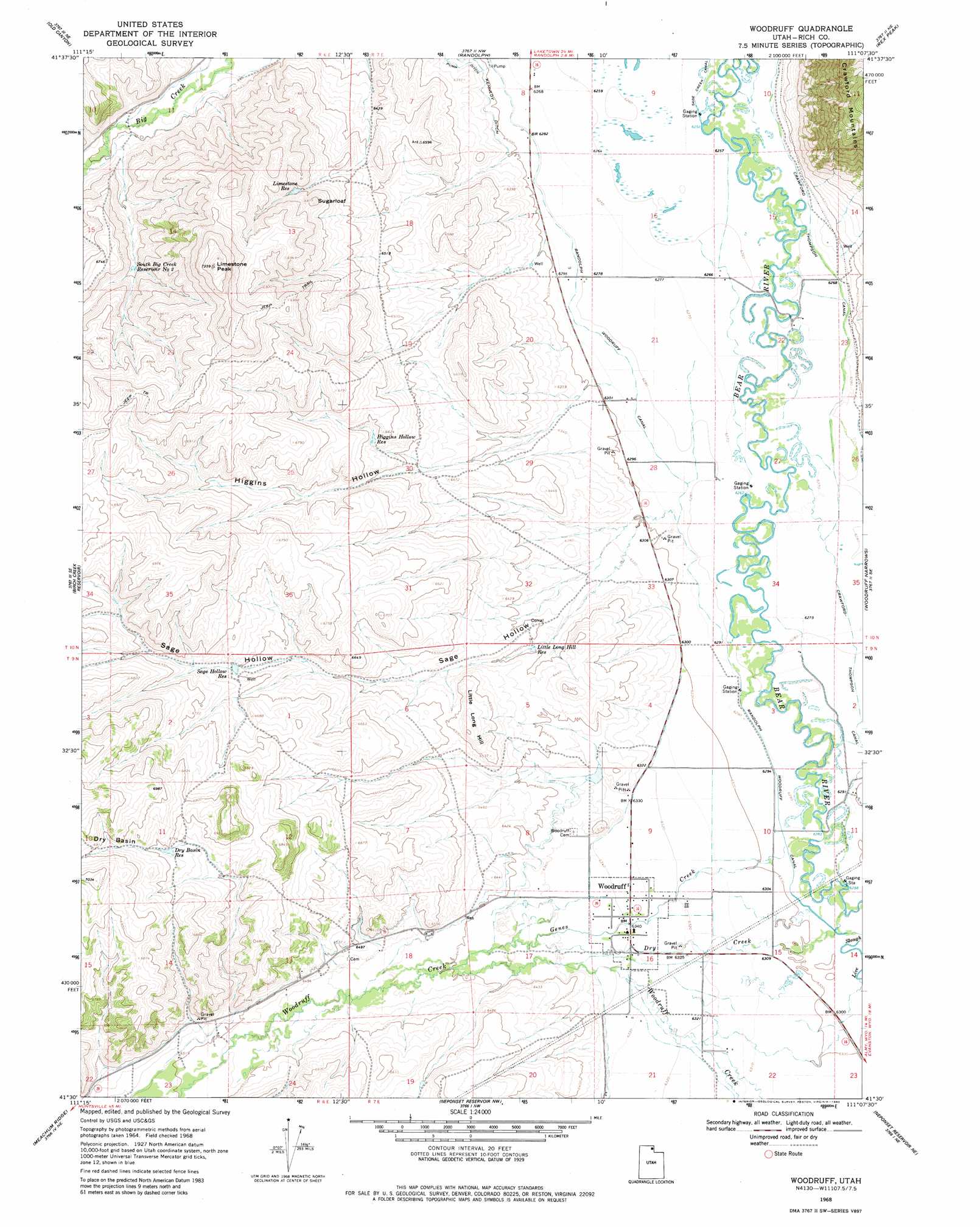
USGS Topo Quad 41111e2 - 1:24,000 scale
| Topo Map Name: | Woodruff |
| USGS Topo Quad ID: | 41111e2 |
| Print Size: | ca. 21 1/4" wide x 27" high |
| Southeast Coordinates: | 41.5° N latitude / 111.125° W longitude |
| Map Center Coordinates: | 41.5625° N latitude / 111.1875° W longitude |
| U.S. State: | UT |
| Filename: | o41111e2.jpg |
| Download Map JPG Image: | Woodruff topo map 1:24,000 scale |
| Map Type: | Topographic |
| Topo Series: | 7.5´ |
| Map Scale: | 1:24,000 |
| Source of Map Images: | United States Geological Survey (USGS) |
| Alternate Map Versions: |
Woodruff UT 1968, updated 1970 Download PDF Buy paper map Woodruff UT 1968, updated 1980 Download PDF Buy paper map Woodruff UT 2011 Download PDF Buy paper map Woodruff UT 2014 Download PDF Buy paper map |
1:24,000 Topo Quads surrounding Woodruff
Meadowville |
Laketown |
Sage Creek |
Leefe |
Sage |
Red Spur Mountain |
Old Canyon |
Randolph |
Rex Peak |
Windy Point |
Curtis Ridge |
Birch Creek Reservoirs |
Woodruff |
Woodruff Narrows |
Sawtooth Mountain |
Dairy Ridge |
Meachum Ridge |
Neponset Reservoir Nw |
Neponset Reservoir Ne |
Three Forks |
Horse Ridge |
Peck Canyon |
Mckay Hollow |
Murphy Ridge |
Evanston |
> Back to 41111e1 at 1:100,000 scale
> Back to 41110a1 at 1:250,000 scale
> Back to U.S. Topo Maps home
Woodruff topo map: Gazetteer
Woodruff: Basins
Dry Basin elevation 2097m 6879′Woodruff: Canals
Crawford Thompson Canal elevation 1912m 6272′Randolph Woodruff Canal elevation 1917m 6289′
Woodruff: Populated Places
Woodruff elevation 1932m 6338′Woodruff: Reservoirs
Dry Basin Reservoir elevation 2063m 6768′Higgins Hollow Reservoir elevation 2005m 6578′
Limestone Reservoir elevation 2034m 6673′
Little Long Hill Reservoir elevation 1946m 6384′
Sage Hollow Reservoir elevation 2013m 6604′
South Big Creek Reservoir Number 2 elevation 2008m 6587′
Woodruff: Streams
Dry Creek elevation 1919m 6295′Genes Creek elevation 1919m 6295′
Woodruff: Summits
Limestone Peak elevation 2224m 7296′Little Long Hill elevation 2006m 6581′
Sugarloaf elevation 2072m 6797′
Woodruff: Valleys
Higgins Hollow elevation 1925m 6315′Sage Hollow elevation 1930m 6332′
Woodruff digital topo map on disk
Buy this Woodruff topo map showing relief, roads, GPS coordinates and other geographical features, as a high-resolution digital map file on DVD: