Meadowville Topo Map Utah
To zoom in, hover over the map of Meadowville
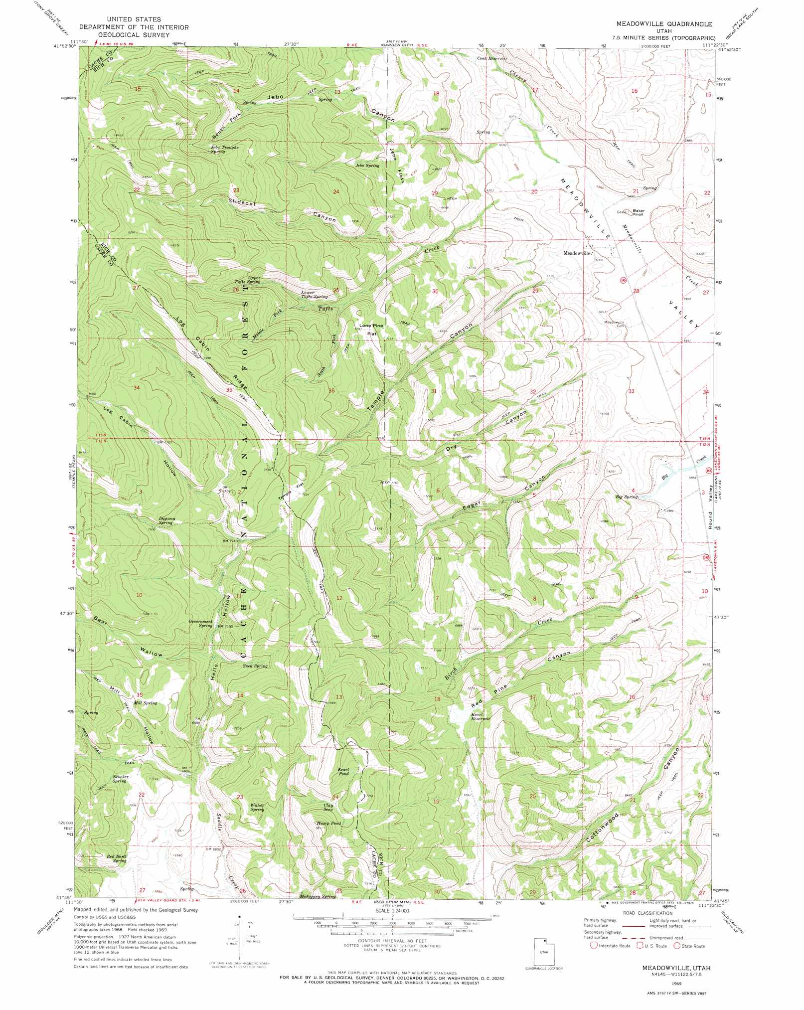
USGS Topo Quad 41111g4 - 1:24,000 scale
| Topo Map Name: | Meadowville |
| USGS Topo Quad ID: | 41111g4 |
| Print Size: | ca. 21 1/4" wide x 27" high |
| Southeast Coordinates: | 41.75° N latitude / 111.375° W longitude |
| Map Center Coordinates: | 41.8125° N latitude / 111.4375° W longitude |
| U.S. State: | UT |
| Filename: | o41111g4.jpg |
| Download Map JPG Image: | Meadowville topo map 1:24,000 scale |
| Map Type: | Topographic |
| Topo Series: | 7.5´ |
| Map Scale: | 1:24,000 |
| Source of Map Images: | United States Geological Survey (USGS) |
| Alternate Map Versions: |
Meadowville UT 1969, updated 1973 Download PDF Buy paper map Meadowville UT 1998, updated 2001 Download PDF Buy paper map Meadowville UT 2011 Download PDF Buy paper map Meadowville UT 2014 Download PDF Buy paper map |
| FStopo: | US Forest Service topo Meadowville is available: Download FStopo PDF Download FStopo TIF |
1:24,000 Topo Quads surrounding Meadowville
Mapleton |
Egan Basin |
Saint Charles |
Bear Lake North |
Pegram Creek |
Naomi Peak |
Tony Grove Creek |
Garden City |
Bear Lake South |
Sheeppen Creek |
Mount Elmer |
Temple Peak |
Meadowville |
Laketown |
Sage Creek |
Logan Peak |
Boulder Mountain |
Red Spur Mountain |
Old Canyon |
Randolph |
Porcupine Reservoir |
Hardware Ranch |
Curtis Ridge |
Birch Creek Reservoirs |
Woodruff |
> Back to 41111e1 at 1:100,000 scale
> Back to 41110a1 at 1:250,000 scale
> Back to U.S. Topo Maps home
Meadowville topo map: Gazetteer
Meadowville: Flats
Jebo Flats elevation 2046m 6712′Lone Pine Flat elevation 2198m 7211′
Temple Flat elevation 2304m 7559′
Meadowville: Populated Places
Meadowville elevation 1836m 6023′Meadowville: Reservoirs
Cook Reservoir elevation 1927m 6322′Hump Pond elevation 2312m 7585′
Kearl Pond elevation 2340m 7677′
Kearl Reservoir elevation 2150m 7053′
Meadowville: Ridges
Log Cabin Ridge elevation 2440m 8005′Meadowville: Springs
Big Spring elevation 1823m 5980′Clay Seep elevation 2295m 7529′
Dugway Spring elevation 2290m 7513′
Government Spring elevation 2184m 7165′
Jebo Spring elevation 2132m 6994′
Jebo Troughs Spring elevation 2382m 7814′
Lower Tufts Spring elevation 2179m 7148′
Mahogany Spring elevation 2123m 6965′
Mill Spring elevation 2181m 7155′
Nebeker Spring elevation 2169m 7116′
Red Bank Spring elevation 2119m 6952′
Suck Spring elevation 2210m 7250′
Upper Tufts Spring elevation 2234m 7329′
Willow Spring elevation 2185m 7168′
Meadowville: Streams
Birch Creek elevation 1837m 6026′Middle Fork Tufts Creek elevation 2153m 7063′
South Fork Tufts Creek elevation 2106m 6909′
Tufts Creek elevation 1835m 6020′
Meadowville: Summits
Baker Knoll elevation 1833m 6013′Meadowville: Valleys
Bear Wallow elevation 2162m 7093′Dry Canyon elevation 1837m 6026′
Edgar Canyon elevation 1836m 6023′
Hells Hollow elevation 2061m 6761′
Jebo Canyon elevation 1856m 6089′
Log Cabin Hollow elevation 2264m 7427′
Mill Hollow elevation 2108m 6916′
Red Pine Canyon elevation 1860m 6102′
Slideout Canyon elevation 1995m 6545′
South Fork Jebo Canyon elevation 2240m 7349′
Temple Canyon elevation 1846m 6056′
Meadowville digital topo map on disk
Buy this Meadowville topo map showing relief, roads, GPS coordinates and other geographical features, as a high-resolution digital map file on DVD: