Big Hat Mountain Topo Map Nevada
To zoom in, hover over the map of Big Hat Mountain
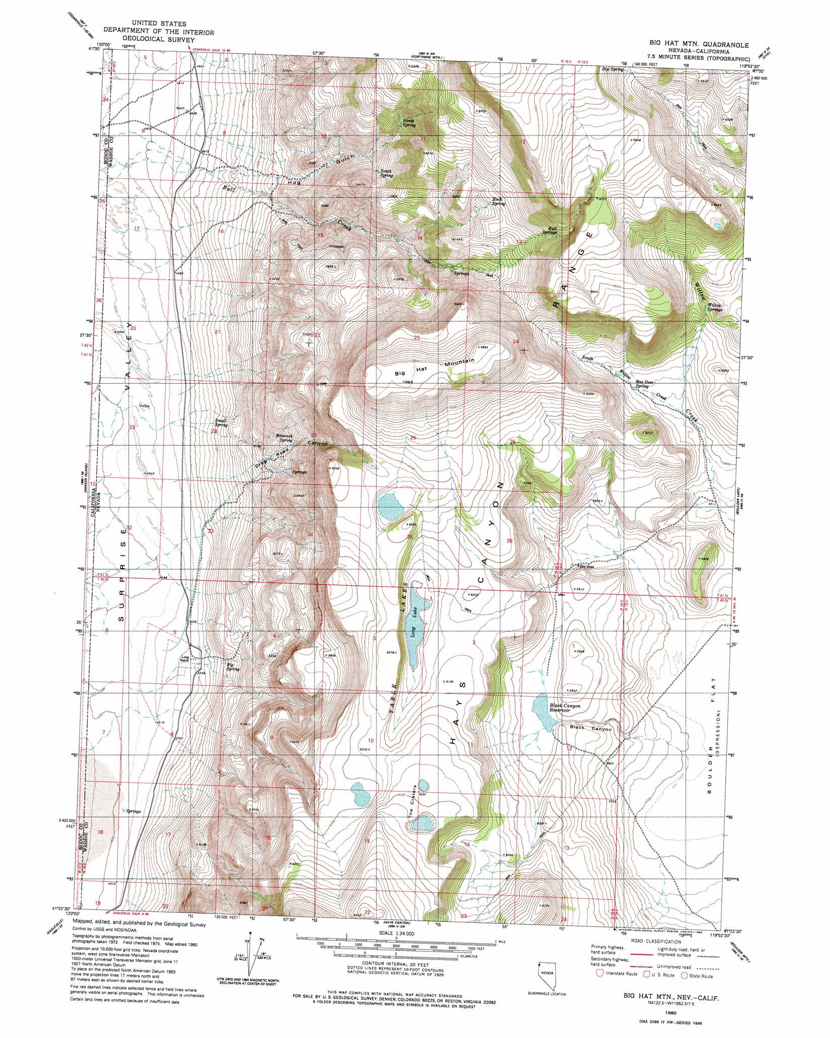
USGS Topo Quad 41119d8 - 1:24,000 scale
| Topo Map Name: | Big Hat Mountain |
| USGS Topo Quad ID: | 41119d8 |
| Print Size: | ca. 21 1/4" wide x 27" high |
| Southeast Coordinates: | 41.375° N latitude / 119.875° W longitude |
| Map Center Coordinates: | 41.4375° N latitude / 119.9375° W longitude |
| U.S. States: | NV, CA |
| Filename: | o41119d8.jpg |
| Download Map JPG Image: | Big Hat Mountain topo map 1:24,000 scale |
| Map Type: | Topographic |
| Topo Series: | 7.5´ |
| Map Scale: | 1:24,000 |
| Source of Map Images: | United States Geological Survey (USGS) |
| Alternate Map Versions: |
Big Hat Mtn. NV 1980, updated 1980 Download PDF Buy paper map Big Hat Mtn NV 1980, updated 1980 Download PDF Buy paper map Big Hat Mountain NV 2011 Download PDF Buy paper map Big Hat Mountain NV 2015 Download PDF Buy paper map |
1:24,000 Topo Quads surrounding Big Hat Mountain
Lake City |
Boyd Hot Spring |
Carter Reservoir |
Alkali Lake |
Massacre Lake Nw |
Cedarville |
Leonards Hot Springs |
Fortynine Mountain |
Vya |
Painted Point |
Warren Peak |
Hansen Island |
Big Hat Mountain |
Boulder Lake |
Powers Well |
Eagle Peak |
Eagleville |
Hays Canyon |
Boulder Mountain |
Pinto Springs |
Emerson Peak |
Snake Lake |
Pegleg Canyon |
Wall Canyon Reservoir |
Bordwell Spring |
> Back to 41119a1 at 1:100,000 scale
> Back to 41118a1 at 1:250,000 scale
> Back to U.S. Topo Maps home
Big Hat Mountain topo map: Gazetteer
Big Hat Mountain: Craters
The Craters elevation 1913m 6276′Big Hat Mountain: Lakes
Long Lake elevation 1857m 6092′Table Lakes elevation 1859m 6099′
Big Hat Mountain: Reservoirs
Black Canyon Reservoir elevation 1788m 5866′Crampton Troughs elevation 1876m 6154′
Big Hat Mountain: Springs
Big Spring elevation 1426m 4678′Bull Springs elevation 1952m 6404′
Dip Spring elevation 2032m 6666′
North Spring elevation 1799m 5902′
Rimrock Spring elevation 1607m 5272′
Rock Spring elevation 1887m 6190′
Roe Deer Spring elevation 1781m 5843′
Small Spring elevation 1424m 4671′
South Spring elevation 1709m 5606′
Willow Springs elevation 1834m 6017′
Big Hat Mountain: Streams
South Willow Creek elevation 1770m 5807′Big Hat Mountain: Summits
Big Hat Mountain elevation 2082m 6830′Big Hat Mountain: Valleys
Black Canyon elevation 1734m 5688′Drag Road Canyon elevation 1383m 4537′
Hog Gulch elevation 1491m 4891′
Big Hat Mountain: Wells
Dry Well elevation 1751m 5744′Big Hat Mountain digital topo map on disk
Buy this Big Hat Mountain topo map showing relief, roads, GPS coordinates and other geographical features, as a high-resolution digital map file on DVD: