Horseheads Topo Map New York
To zoom in, hover over the map of Horseheads
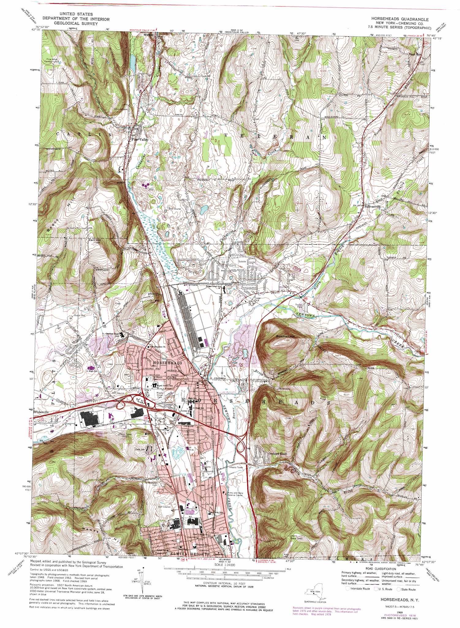
USGS Topo Quad 42076b7 - 1:24,000 scale
| Topo Map Name: | Horseheads |
| USGS Topo Quad ID: | 42076b7 |
| Print Size: | ca. 21 1/4" wide x 27" high |
| Southeast Coordinates: | 42.125° N latitude / 76.75° W longitude |
| Map Center Coordinates: | 42.1875° N latitude / 76.8125° W longitude |
| U.S. State: | NY |
| Filename: | o42076b7.jpg |
| Download Map JPG Image: | Horseheads topo map 1:24,000 scale |
| Map Type: | Topographic |
| Topo Series: | 7.5´ |
| Map Scale: | 1:24,000 |
| Source of Map Images: | United States Geological Survey (USGS) |
| Alternate Map Versions: |
Horseheads NY 1953, updated 1955 Download PDF Buy paper map Horseheads NY 1953, updated 1964 Download PDF Buy paper map Horseheads NY 1969, updated 1971 Download PDF Buy paper map Horseheads NY 1978, updated 1979 Download PDF Buy paper map Horseheads NY 1978, updated 1984 Download PDF Buy paper map Horseheads NY 2010 Download PDF Buy paper map Horseheads NY 2013 Download PDF Buy paper map Horseheads NY 2016 Download PDF Buy paper map |
1:24,000 Topo Quads surrounding Horseheads
Wayne |
Reading Center |
Burdett |
Mecklenburg |
Ithaca West |
Bradford |
Beaver Dams |
Montour Falls |
Alpine |
West Danby |
Corning |
Big Flats |
Horseheads |
Erin |
Van Etten |
Caton |
Seeley Creek |
Elmira |
Wellsburg |
Waverly |
Jackson Summit |
Millerton |
Gillett |
Bentley Creek |
Sayre |
> Back to 42076a1 at 1:100,000 scale
> Back to 42076a1 at 1:250,000 scale
> Back to U.S. Topo Maps home
Horseheads topo map: Gazetteer
Horseheads: Airports
Dodge-Coppola-Wheeler Airport elevation 316m 1036′Omni Airpark elevation 294m 964′
Horseheads: Populated Places
Elmira Heights elevation 268m 879′Fisherville elevation 282m 925′
Horseheads elevation 273m 895′
Maplehurst Park elevation 293m 961′
Orchard Knoll elevation 303m 994′
Pine Valley elevation 284m 931′
Pine Valley Mobile Home Park elevation 277m 908′
Pioneer Village elevation 277m 908′
Retirement Estates elevation 299m 980′
Rolling Acres Mobile Home Park elevation 272m 892′
Rush Run elevation 433m 1420′
Sullivanville elevation 325m 1066′
Horseheads: Streams
Beaver Brook elevation 272m 892′Bulkley Creek elevation 314m 1030′
Latta Brook elevation 263m 862′
North Branch Newtown Creek elevation 282m 925′
Horseheads: Summits
Beers Hill elevation 452m 1482′Bowman Hill elevation 454m 1489′
Carr Hill elevation 433m 1420′
Hawes Hill elevation 492m 1614′
Horseheads digital topo map on disk
Buy this Horseheads topo map showing relief, roads, GPS coordinates and other geographical features, as a high-resolution digital map file on DVD:
New York, Vermont, Connecticut & Western Massachusetts
Buy digital topo maps: New York, Vermont, Connecticut & Western Massachusetts