East Aurora Topo Map New York
To zoom in, hover over the map of East Aurora
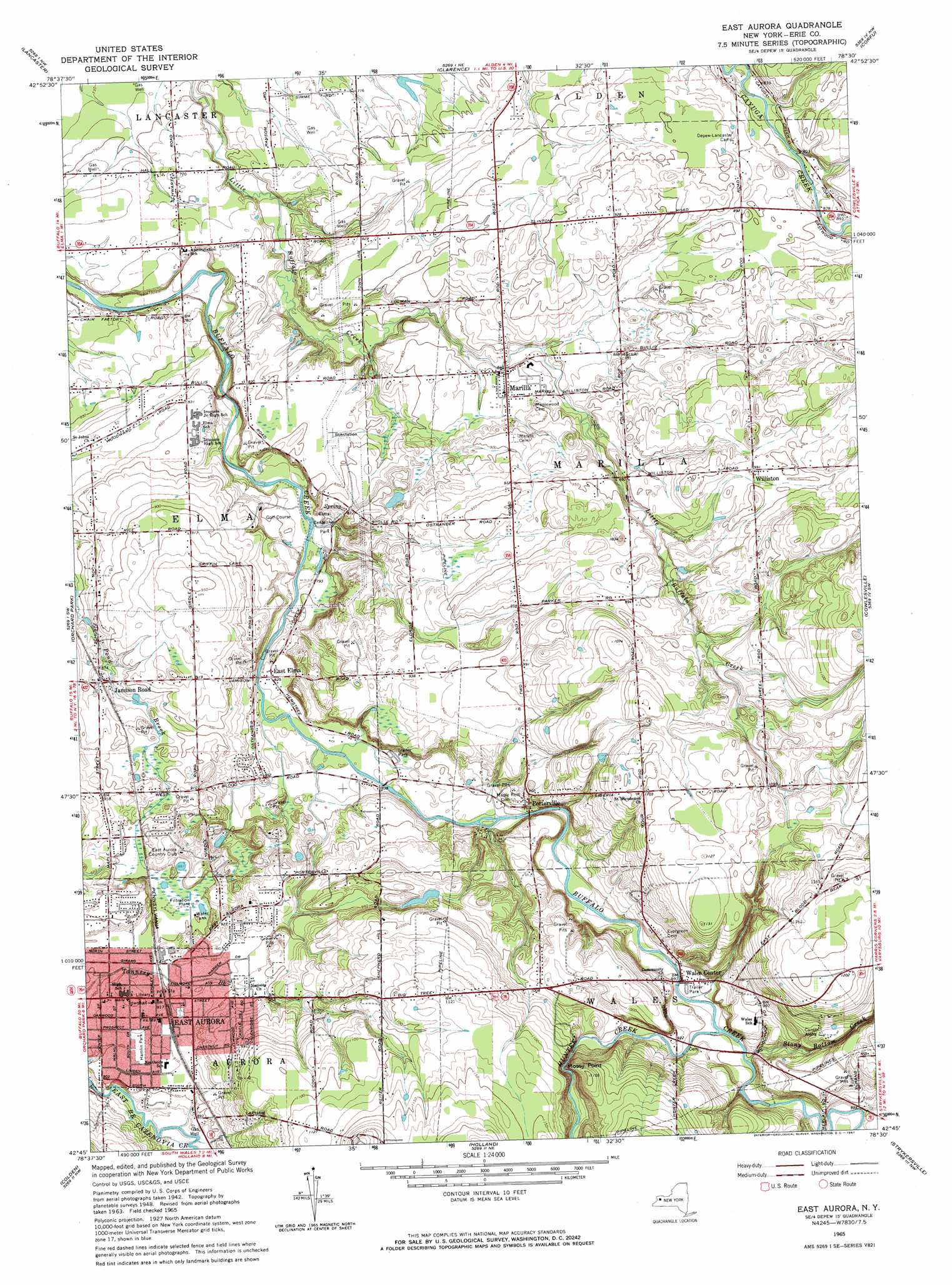
USGS Topo Quad 42078g5 - 1:24,000 scale
| Topo Map Name: | East Aurora |
| USGS Topo Quad ID: | 42078g5 |
| Print Size: | ca. 21 1/4" wide x 27" high |
| Southeast Coordinates: | 42.75° N latitude / 78.5° W longitude |
| Map Center Coordinates: | 42.8125° N latitude / 78.5625° W longitude |
| U.S. State: | NY |
| Filename: | o42078g5.jpg |
| Download Map JPG Image: | East Aurora topo map 1:24,000 scale |
| Map Type: | Topographic |
| Topo Series: | 7.5´ |
| Map Scale: | 1:24,000 |
| Source of Map Images: | United States Geological Survey (USGS) |
| Alternate Map Versions: |
East Aurora NY 1950 Download PDF Buy paper map East Aurora NY 1965, updated 1967 Download PDF Buy paper map East Aurora NY 1965, updated 1967 Download PDF Buy paper map East Aurora NY 2010 Download PDF Buy paper map East Aurora NY 2013 Download PDF Buy paper map East Aurora NY 2016 Download PDF Buy paper map |
1:24,000 Topo Quads surrounding East Aurora
Tonawanda East |
Clarence Center |
Wolcottsville |
Akron |
Oakfield |
Buffalo Ne |
Clarence |
Alexander |
||
Buffalo Se |
Orchard Park |
East Aurora |
Cowlesville |
Attica |
Hamburg |
Colden |
Holland |
Strykersville |
Johnsonburg |
Langford |
Springville |
Sardinia |
Arcade |
Bliss |
> Back to 42078e1 at 1:100,000 scale
> Back to 42078a1 at 1:250,000 scale
> Back to U.S. Topo Maps home
East Aurora topo map: Gazetteer
East Aurora: Airports
Donnellys Airport elevation 310m 1017′East Aurora: Cliffs
Mossy Point elevation 334m 1095′East Aurora: Parks
Elma Centennial Park elevation 241m 790′Hamlin Park elevation 277m 908′
East Aurora: Populated Places
East Aurora elevation 280m 918′East Elma elevation 251m 823′
Jamison Road elevation 268m 879′
Marilla elevation 258m 846′
Porterville elevation 284m 931′
Wales Center elevation 271m 889′
Williston elevation 302m 990′
East Aurora: Streams
Hunter Creek elevation 268m 879′Stony Bottom Creek elevation 272m 892′
East Aurora digital topo map on disk
Buy this East Aurora topo map showing relief, roads, GPS coordinates and other geographical features, as a high-resolution digital map file on DVD:
 map DVD")