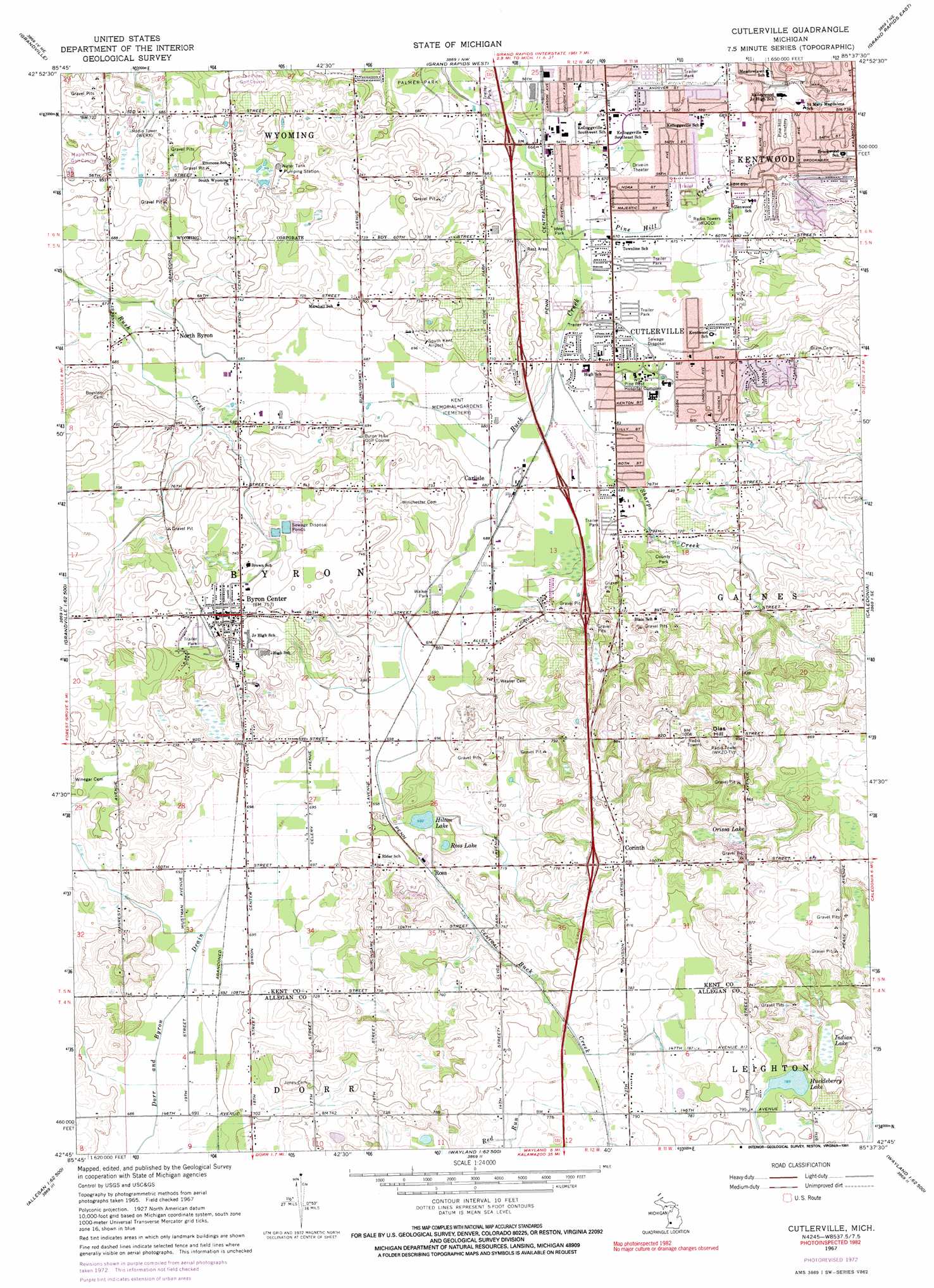
Cutlerville Topo Map Michigan
To zoom in, hover over the map of Cutlerville
USGS Topo Quad 42085g6 - 1:24,000 scale
| Topo Map Name: | Cutlerville |
| USGS Topo Quad ID: | 42085g6 |
| Print Size: | ca. 21 1/4" wide x 27" high |
| Southeast Coordinates: | 42.75° N latitude / 85.625° W longitude |
| Map Center Coordinates: | 42.8125° N latitude / 85.6875° W longitude |
| U.S. State: | MI |
| Filename: | o42085g6.jpg |
| Download Map JPG Image: | Cutlerville topo map 1:24,000 scale |
| Map Type: | Topographic |
| Topo Series: | 7.5´ |
| Map Scale: | 1:24,000 |
| Source of Map Images: | United States Geological Survey (USGS) |
| Alternate Map Versions: |
Cutlerville MI 1967, updated 1969 Download PDF Buy paper map Cutlerville MI 1967, updated 1973 Download PDF Buy paper map Cutlerville MI 1967, updated 1991 Download PDF Buy paper map Cutlerville MI 2011 Download PDF Buy paper map Cutlerville MI 2014 Download PDF Buy paper map Cutlerville MI 2016 Download PDF Buy paper map |
1:24,000 Topo Quads surrounding Cutlerville
Coopersville |
Marne |
Cedar Springs Sw |
Rockford |
Cannonsburg |
Allendale |
Grandville |
Grand Rapids West |
Grand Rapids East |
Cascade |
Hudsonville West |
Hudsonville East |
Cutlerville |
Caledonia |
Alto |
Hamilton East |
Burnips |
Wayland |
Bowens Mill |
Middleville |
Millgrove |
Allegan |
Martin |
Orangeville |
Cloverdale |
> Back to 42085e1 at 1:100,000 scale
> Back to 42084a1 at 1:250,000 scale
> Back to U.S. Topo Maps home
Cutlerville topo map: Gazetteer
Cutlerville: Crossings
Interchange 5 elevation 224m 734′Interchange 72 elevation 244m 800′
Interchange 74 elevation 230m 754′
Interchange 75 elevation 210m 688′
Interchange 76 elevation 216m 708′
Interchange 77 elevation 222m 728′
Interchange 78 elevation 208m 682′
Cutlerville: Lakes
Hilton Lake elevation 211m 692′Huckleberry Lake elevation 240m 787′
Ross Lake elevation 211m 692′
Cutlerville: Parks
Byron Township Hall Historical Marker elevation 228m 748′Creekside Park elevation 219m 718′
Gezon Park elevation 209m 685′
Ideal Park elevation 202m 662′
Jaycee Park elevation 215m 705′
John Isaac Cutler House Historical Marker elevation 205m 672′
Kellogg Woods Park elevation 204m 669′
Kelloggsville Park elevation 204m 669′
Walker Park elevation 208m 682′
Cutlerville: Populated Places
Brentwood Mobile Village elevation 205m 672′Byron Center elevation 228m 748′
Byron Center Mobile Village elevation 224m 734′
Carlisle elevation 208m 682′
Corinth elevation 245m 803′
Creekside Estates Mobile Home Park elevation 201m 659′
Cutlerville elevation 206m 675′
Green Meadow Village Mobile Home Park elevation 205m 672′
Kentwood elevation 210m 688′
Maplewood Mobile Home Park elevation 204m 669′
North Byron elevation 211m 692′
Pinebrook Village Mobile Home Park elevation 207m 679′
Ross elevation 216m 708′
Southwood Village Mobile Home Park elevation 211m 692′
Cutlerville: Post Offices
Byron Center Post Office elevation 226m 741′Corinth Post Office (historical) elevation 245m 803′
Fishers Station Post Office (historical) elevation 204m 669′
North Byron Post Office (historical) elevation 211m 692′
Ross Post Office (historical) elevation 215m 705′
West Carlisle Post Office (historical) elevation 207m 679′
Cutlerville: Streams
Pine Hill Creek elevation 201m 659′Sharps Creek elevation 204m 669′
Cutlerville: Summits
Dias Hill elevation 318m 1043′Cutlerville: Swamps
Indian Lake elevation 243m 797′Orissa Lake elevation 248m 813′
Cutlerville digital topo map on disk
Buy this Cutlerville topo map showing relief, roads, GPS coordinates and other geographical features, as a high-resolution digital map file on DVD:
Northern Illinois, Northern Indiana & Southwestern Michigan
Buy digital topo maps: Northern Illinois, Northern Indiana & Southwestern Michigan