The Q Ranch Topo Map Wyoming
To zoom in, hover over the map of The Q Ranch
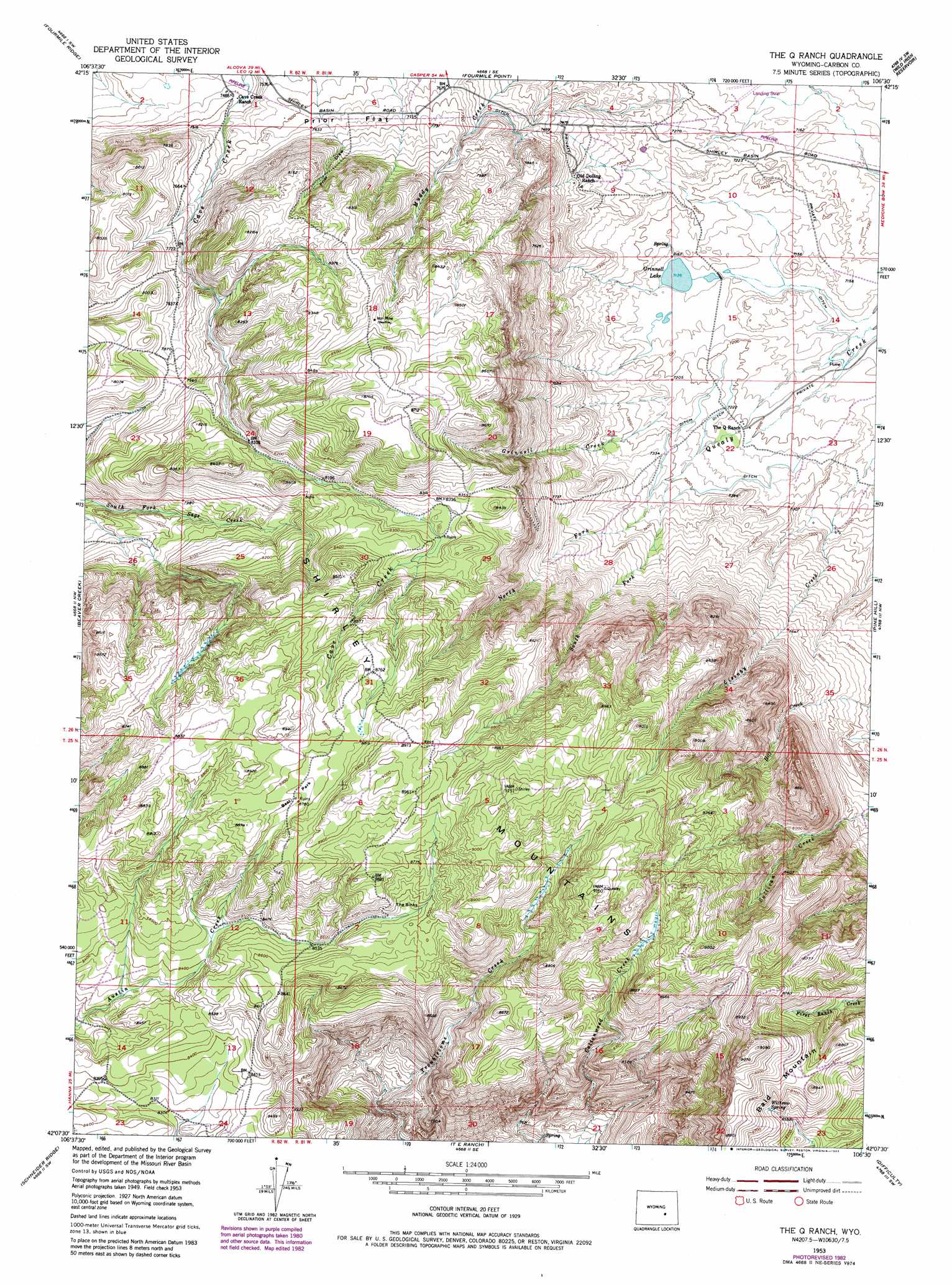
USGS Topo Quad 42106b5 - 1:24,000 scale
| Topo Map Name: | The Q Ranch |
| USGS Topo Quad ID: | 42106b5 |
| Print Size: | ca. 21 1/4" wide x 27" high |
| Southeast Coordinates: | 42.125° N latitude / 106.5° W longitude |
| Map Center Coordinates: | 42.1875° N latitude / 106.5625° W longitude |
| U.S. State: | WY |
| Filename: | o42106b5.jpg |
| Download Map JPG Image: | The Q Ranch topo map 1:24,000 scale |
| Map Type: | Topographic |
| Topo Series: | 7.5´ |
| Map Scale: | 1:24,000 |
| Source of Map Images: | United States Geological Survey (USGS) |
| Alternate Map Versions: |
The Q Ranch WY 1953, updated 1955 Download PDF Buy paper map The Q Ranch WY 1953, updated 1971 Download PDF Buy paper map The Q Ranch WY 1953, updated 1980 Download PDF Buy paper map The Q Ranch WY 1953, updated 1983 Download PDF Buy paper map The Q Ranch WY 2012 Download PDF Buy paper map The Q Ranch WY 2015 Download PDF Buy paper map |
1:24,000 Topo Quads surrounding The Q Ranch
Pathfinder Dam |
Bear Spring |
Bear Mountain |
Horse Peak |
Mud Springs |
Leo |
Fourmile Ridge |
Fourmile Point |
Wild Irish Reservoir |
Measel Spring Reservoir |
Seminoe Dam Ne |
Beaver Creek |
The Q Ranch |
Pine Hill |
Cameron Creek |
Seminoe Dam Se |
Schneider Ridge |
T E Ranch |
Difficulty |
Windy Hill |
Pats Bottom |
Tenmile Spring |
Elmo |
Como West |
Como East |
> Back to 42106a1 at 1:100,000 scale
> Back to 42106a1 at 1:250,000 scale
> Back to U.S. Topo Maps home
The Q Ranch topo map: Gazetteer
The Q Ranch: Basins
Shirley Basin elevation 2184m 7165′The Sinks elevation 2639m 8658′
The Q Ranch: Flats
Prior Flat elevation 2330m 7644′The Q Ranch: Lakes
Grinnell Lake elevation 2177m 7142′The Q Ranch: Mines
Jim Claims Mine elevation 2657m 8717′The Q Ranch: Parks
Bear Park elevation 2677m 8782′The Q Ranch: Springs
Withrow Spring elevation 2637m 8651′The Q Ranch: Streams
Grinnell Creek elevation 2208m 7244′North Fork Quealy Creek elevation 2225m 7299′
South Fork Quealy Creek elevation 2225m 7299′
The Q Ranch: Valleys
Prior Draw elevation 2323m 7621′The Q Ranch digital topo map on disk
Buy this The Q Ranch topo map showing relief, roads, GPS coordinates and other geographical features, as a high-resolution digital map file on DVD:
Eastern Wyoming & Western South Dakota
Buy digital topo maps: Eastern Wyoming & Western South Dakota