Big Butte Springs Topo Map Oregon
To zoom in, hover over the map of Big Butte Springs
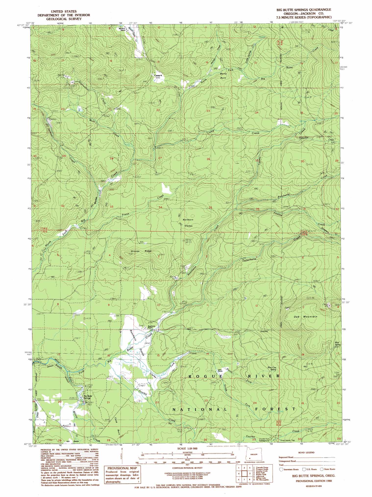
USGS Topo Quad 42122e4 - 1:24,000 scale
| Topo Map Name: | Big Butte Springs |
| USGS Topo Quad ID: | 42122e4 |
| Print Size: | ca. 21 1/4" wide x 27" high |
| Southeast Coordinates: | 42.5° N latitude / 122.375° W longitude |
| Map Center Coordinates: | 42.5625° N latitude / 122.4375° W longitude |
| U.S. State: | OR |
| Filename: | o42122e4.jpg |
| Download Map JPG Image: | Big Butte Springs topo map 1:24,000 scale |
| Map Type: | Topographic |
| Topo Series: | 7.5´ |
| Map Scale: | 1:24,000 |
| Source of Map Images: | United States Geological Survey (USGS) |
| Alternate Map Versions: |
Big Butte Springs OR 1988, updated 1988 Download PDF Buy paper map Big Butte Springs OR 1997, updated 2000 Download PDF Buy paper map Big Butte Springs OR 2011 Download PDF Buy paper map Big Butte Springs OR 2014 Download PDF Buy paper map |
| FStopo: | US Forest Service topo Big Butte Springs is available: Download FStopo PDF Download FStopo TIF |
1:24,000 Topo Quads surrounding Big Butte Springs
Sugarpine Creek |
Whetstone Point |
Prospect North |
Red Blanket Mountain |
Union Peak |
Mcleod |
Cascade Gorge |
Prospect South |
Imnaha Creek |
Devils Peak |
Obenchain Mountain |
Butte Falls |
Big Butte Springs |
Rustler Peak |
Pelican Butte |
Brownsboro |
Lakecreek |
Willow Lake |
Mount Mcloughlin |
Lake Of The Woods North |
Rio Canyon |
Grizzly Peak |
Robinson Butte |
Brown Mountain |
Lake Of The Woods South |
> Back to 42122e1 at 1:100,000 scale
> Back to 42122a1 at 1:250,000 scale
> Back to U.S. Topo Maps home
Big Butte Springs topo map: Gazetteer
Big Butte Springs: Areas
Merle Burn elevation 1006m 3300′Rancheria Prairie elevation 827m 2713′
Big Butte Springs: Flats
Northern Glades elevation 944m 3097′Big Butte Springs: Post Offices
Lemont Post Office (historical) elevation 965m 3166′Big Butte Springs: Ridges
Grouse Ridge elevation 949m 3113′Big Butte Springs: Springs
Big Butte Springs elevation 824m 2703′Blue Cow Spring elevation 998m 3274′
Mud Spring elevation 828m 2716′
Big Butte Springs: Streams
Ash Creek elevation 821m 2693′Camp Creek elevation 893m 2929′
Cedar Springs Creek elevation 1002m 3287′
Clarks Fork Creek elevation 825m 2706′
Deception Creek elevation 1058m 3471′
East Fork Ash Creek elevation 831m 2726′
Fireline Creek elevation 915m 3001′
Fourbit Creek elevation 820m 2690′
Friese Creek elevation 841m 2759′
Horseshoe Creek elevation 910m 2985′
Jackass Creek elevation 853m 2798′
Mule Creek elevation 875m 2870′
North Fork Clarks Fork Creek elevation 895m 2936′
Phillips Creek elevation 956m 3136′
Rancheria Creek elevation 846m 2775′
South Fork Clarks Fork Creek elevation 895m 2936′
Timberline Creek elevation 1077m 3533′
Titanic Creek elevation 913m 2995′
Twincheria Creek elevation 846m 2775′
West Fork Ash Creek elevation 831m 2726′
Willow Creek elevation 802m 2631′
Big Butte Springs: Summits
Oak Mountain elevation 1210m 3969′Big Butte Springs digital topo map on disk
Buy this Big Butte Springs topo map showing relief, roads, GPS coordinates and other geographical features, as a high-resolution digital map file on DVD: