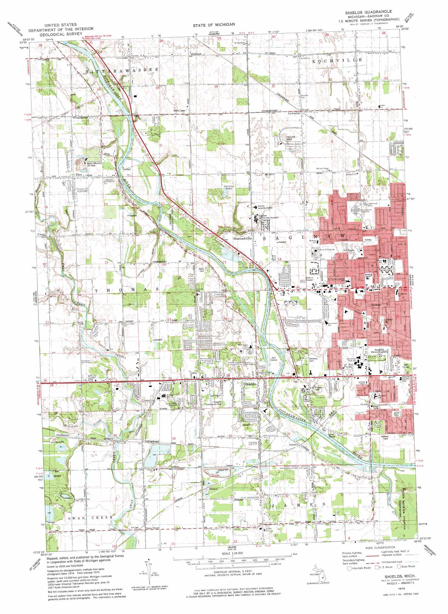
Shields Topo Map Michigan
To zoom in, hover over the map of Shields
USGS Topo Quad 43084d1 - 1:24,000 scale
| Topo Map Name: | Shields |
| USGS Topo Quad ID: | 43084d1 |
| Print Size: | ca. 21 1/4" wide x 27" high |
| Southeast Coordinates: | 43.375° N latitude / 84° W longitude |
| Map Center Coordinates: | 43.4375° N latitude / 84.0625° W longitude |
| U.S. State: | MI |
| Filename: | o43084d1.jpg |
| Download Map JPG Image: | Shields topo map 1:24,000 scale |
| Map Type: | Topographic |
| Topo Series: | 7.5´ |
| Map Scale: | 1:24,000 |
| Source of Map Images: | United States Geological Survey (USGS) |
| Alternate Map Versions: |
Shields MI 1975, updated 1978 Download PDF Buy paper map Shields MI 2011 Download PDF Buy paper map Shields MI 2014 Download PDF Buy paper map Shields MI 2016 Download PDF Buy paper map |
1:24,000 Topo Quads surrounding Shields
Averill |
Midland North |
Willard |
Kawkawlin |
Bay City Ne |
Gordonville |
Midland South |
Auburn |
Bay City |
Essexville |
Merrill |
Hemlock |
Shields |
Saginaw |
Saginaw Ne |
Lakefield |
Saint Charles |
Alicia |
Bridgeport |
Birch Run North |
Chapin |
Chesaning West |
Chesaning East |
Montrose |
Birch Run South |
> Back to 43084a1 at 1:100,000 scale
> Back to 43084a1 at 1:250,000 scale
> Back to U.S. Topo Maps home
Shields topo map: Gazetteer
Shields: Canals
Dice Drain elevation 185m 606′Huffman Drain elevation 184m 603′
Shields: Guts
Bullhead Creek elevation 178m 583′Shields: Parks
Berberovich Park elevation 190m 623′Burkhaven Park elevation 187m 613′
Day Park elevation 181m 593′
George Olson Recreation Complex elevation 190m 623′
Harvey Randall Wickes Recreation Area elevation 187m 613′
Imerman Memorial Park elevation 180m 590′
Leonard Boers III Riverfront Park elevation 180m 590′
North Little League Park elevation 191m 626′
Roberts Community Park elevation 182m 597′
Roethke Park elevation 184m 603′
Saginaw Township Playscape elevation 184m 603′
Shields Men's Club Park elevation 184m 603′
West Michigan Park elevation 179m 587′
Zauel Park elevation 183m 600′
Shields: Populated Places
Dice elevation 187m 613′Frost elevation 183m 600′
Lawndale elevation 193m 633′
Lawndale Estates Mobile Home Park elevation 192m 629′
Paines elevation 181m 593′
Shattuckville elevation 183m 600′
Shields elevation 182m 597′
Swan Creek elevation 181m 593′
Shields: Post Offices
Disc Post Office (historical) elevation 187m 613′Frost Post Office (historical) elevation 183m 600′
Lawndale Post Office (historical) elevation 194m 636′
Paines Post Office (historical) elevation 181m 593′
Shattuckville Post Office (historical) elevation 183m 600′
Shields Post Office (historical) elevation 182m 597′
Swan Creek Post Office (historical) elevation -1m -4′
Shields: Streams
Hatch Run elevation 182m 597′McClellan Run elevation 178m 583′
Williams Creek elevation 178m 583′
Shields digital topo map on disk
Buy this Shields topo map showing relief, roads, GPS coordinates and other geographical features, as a high-resolution digital map file on DVD: