Saginaw Topo Map Michigan
To zoom in, hover over the map of Saginaw
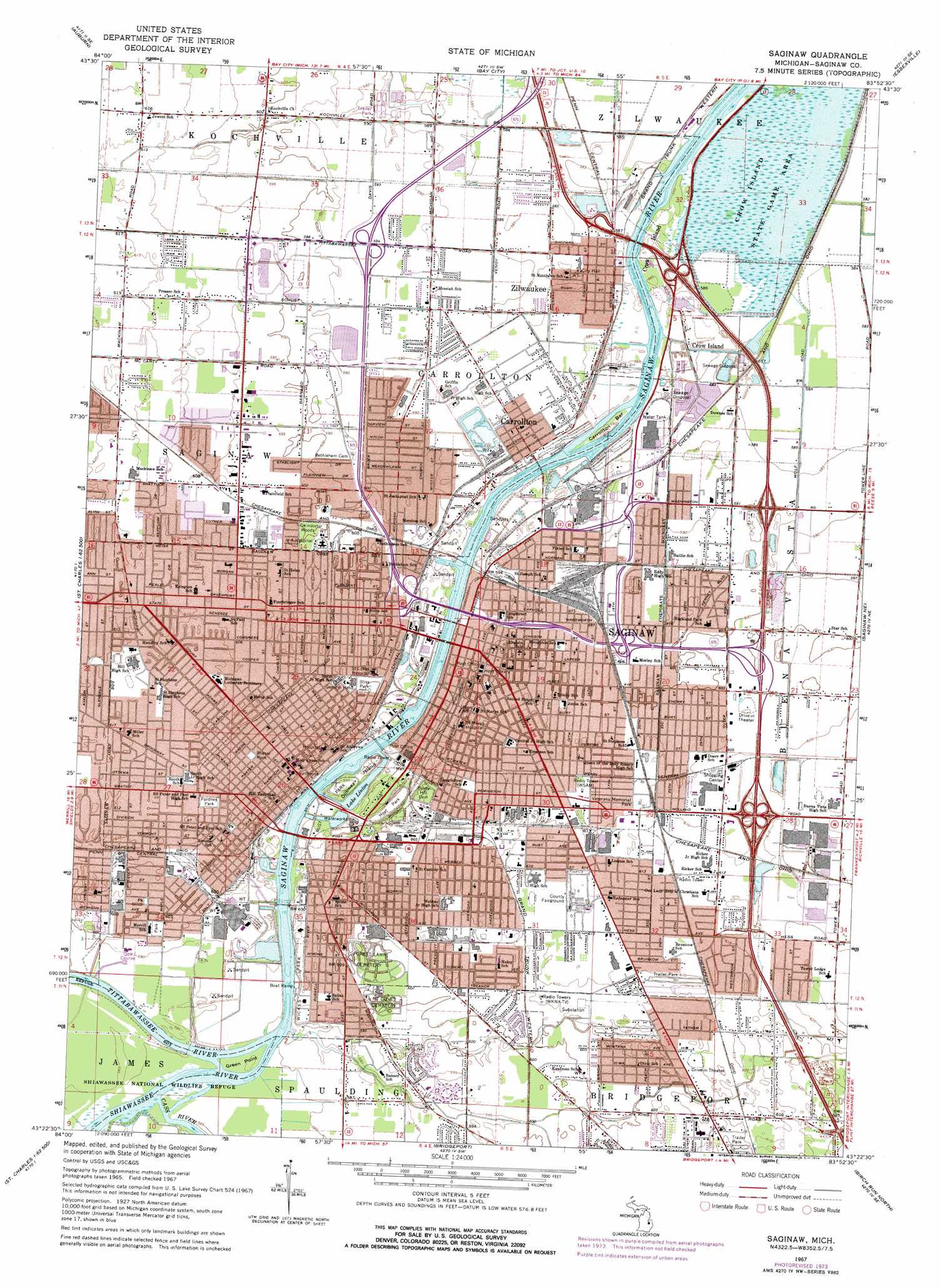
USGS Topo Quad 43083d8 - 1:24,000 scale
| Topo Map Name: | Saginaw |
| USGS Topo Quad ID: | 43083d8 |
| Print Size: | ca. 21 1/4" wide x 27" high |
| Southeast Coordinates: | 43.375° N latitude / 83.875° W longitude |
| Map Center Coordinates: | 43.4375° N latitude / 83.9375° W longitude |
| U.S. State: | MI |
| Filename: | o43083d8.jpg |
| Download Map JPG Image: | Saginaw topo map 1:24,000 scale |
| Map Type: | Topographic |
| Topo Series: | 7.5´ |
| Map Scale: | 1:24,000 |
| Source of Map Images: | United States Geological Survey (USGS) |
| Alternate Map Versions: |
Saginaw MI 1967, updated 1969 Download PDF Buy paper map Saginaw MI 1967, updated 1974 Download PDF Buy paper map Saginaw MI 2011 Download PDF Buy paper map Saginaw MI 2014 Download PDF Buy paper map Saginaw MI 2017 Download PDF Buy paper map |
1:24,000 Topo Quads surrounding Saginaw
Midland North |
Willard |
Kawkawlin |
Bay City Ne |
|
Midland South |
Auburn |
Bay City |
Essexville |
Quanicassee |
Hemlock |
Shields |
Saginaw |
Saginaw Ne |
Reese |
Saint Charles |
Alicia |
Bridgeport |
Birch Run North |
Frankenmuth |
Chesaning West |
Chesaning East |
Montrose |
Birch Run South |
Clio |
> Back to 43083a1 at 1:100,000 scale
> Back to 43082a1 at 1:250,000 scale
> Back to U.S. Topo Maps home
Saginaw topo map: Gazetteer
Saginaw: Airports
Saint Marys Hospital Heliport elevation 182m 597′Saginaw: Crossings
Interchance 2A elevation 182m 597′Interchange 1 elevation 0m 0′
Interchange 149 elevation 0m 0′
Interchange 150 elevation 0m 0′
Interchange 151 elevation 0m 0′
Interchange 153 elevation 0m 0′
Interchange 154 elevation 0m 0′
Interchange 2B elevation 181m 593′
Interchange 3 elevation 0m 0′
Interchange 6 elevation 180m 590′
Saginaw: Islands
Carrollton Bar elevation 180m 590′Green Point elevation 178m 583′
Ojibway Island elevation 180m 590′
Saginaw: Lakes
Haithco Lake elevation 180m 590′Lake Linton elevation 177m 580′
Saginaw: Parks
Arthur Eddy Park elevation 181m 593′Benjamin and Adelaide Cushway Historical Marker elevation 0m 0′
Bethune Park elevation 180m 590′
Bitmore Park elevation 184m 603′
Bliss Park elevation 183m 600′
Bliss Park Historical Marker elevation 0m 0′
Borchard Park elevation 183m 600′
Briarwood Park elevation 189m 620′
Can-Amera Park elevation 188m 616′
Clayton Park elevation 181m 593′
Coulter School Park elevation 181m 593′
Crow Island State Game Area elevation 177m 580′
Cushway House Historical Marker elevation 0m 0′
Derby Downs Park elevation 181m 593′
First Congregational Church Historical Marker elevation 0m 0′
Fordney Park elevation 186m 610′
Garber Tennis Courts elevation 180m 590′
Germaine Park elevation 180m 590′
Green Point Nature Center elevation 178m 583′
Haljean Park elevation 183m 600′
Hanchett Park elevation 0m 0′
Herig Park elevation 184m 603′
Hoyt Library Historical Marker elevation 0m 0′
Hoyt Park elevation 178m 583′
Jeffers Park elevation 181m 593′
Linton Park elevation 181m 593′
Merrill Park Center elevation 182m 597′
Moody Park elevation 182m 597′
Morley School Park elevation 182m 597′
Ojibway Island Park elevation 180m 590′
Park Place elevation 184m 603′
Peach/Iowa Park elevation 184m 603′
Pool Park elevation 178m 583′
Presbyterian Church of South Saginaw Historical Marker elevation 0m 0′
Roeser Park elevation 185m 606′
Rust Park elevation 180m 590′
Saginaw Club Historical Marker elevation 0m 0′
Saginaw Oil Industry Historical Marker elevation 0m 0′
Saginaw Post Office Historical Marker elevation 0m 0′
Saginaw Township Soccer Complex elevation 186m 610′
Saginaw Valley Lumbering Era Historical Marker elevation 0m 0′
Saint Mary's Hospital Historical Marker elevation 0m 0′
Saint Vincents Park elevation 184m 603′
Sandhill Park elevation 186m 610′
Schroeder Park elevation 185m 606′
Second Street Park elevation 182m 597′
Sherman Park elevation 0m 0′
Skivington Park elevation 183m 600′
Stoker Park elevation 0m 0′
Theodore H Roethke Childhood Home Historical Marker elevation 0m 0′
Theodore H Roethke Historical Marker elevation 0m 0′
Unity Park elevation 180m 590′
Veterans Memorial Park elevation 185m 606′
Watson Park elevation 183m 600′
Webber Park elevation 178m 583′
Wickes Park elevation 181m 593′
William H Haithco Recreation Area elevation 180m 590′
Zilwaukee Park elevation 177m 580′
Saginaw: Populated Places
Bel-Air Mobile Home Park elevation 186m 610′Buena Vista elevation 185m 606′
Carrollton elevation 179m 587′
Crow Island elevation 177m 580′
Saginaw elevation 177m 580′
Saginaw Valley Mobile Home Park elevation 178m 583′
Saginaw Village Mobile Home Park elevation 186m 610′
Windmill Estates Mobile Home Park elevation 186m 610′
Zilwaukee elevation 178m 583′
Saginaw: Post Offices
Buena Vista Post Office (historical) elevation 184m 603′Carrollton Post Office elevation 0m 0′
Crow Island Post Office (historical) elevation 177m 580′
Saginaw Post Office elevation 182m 597′
South Saginaw Post Office (historical) elevation 179m 587′
Zilwaukee Post Office (historical) elevation 178m 583′
Saginaw: Streams
Cass River elevation 178m 583′Shiawassee River elevation 177m 580′
Tittabawassee River elevation 177m 580′
Saginaw: Woods
Deindorfer Woods elevation 183m 600′Saginaw digital topo map on disk
Buy this Saginaw topo map showing relief, roads, GPS coordinates and other geographical features, as a high-resolution digital map file on DVD:
 map DVD")