Hilight Topo Map Wyoming
To zoom in, hover over the map of Hilight
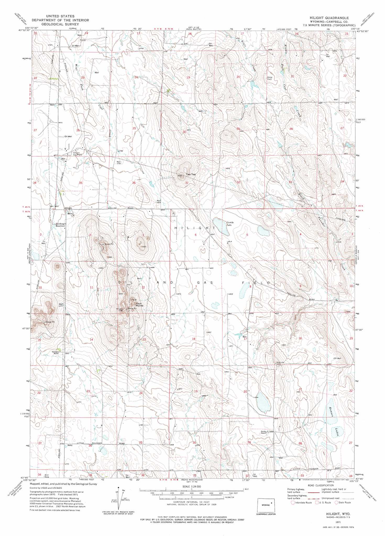
USGS Topo Quad 43105g3 - 1:24,000 scale
| Topo Map Name: | Hilight |
| USGS Topo Quad ID: | 43105g3 |
| Print Size: | ca. 21 1/4" wide x 27" high |
| Southeast Coordinates: | 43.75° N latitude / 105.25° W longitude |
| Map Center Coordinates: | 43.8125° N latitude / 105.3125° W longitude |
| U.S. State: | WY |
| Filename: | o43105g3.jpg |
| Download Map JPG Image: | Hilight topo map 1:24,000 scale |
| Map Type: | Topographic |
| Topo Series: | 7.5´ |
| Map Scale: | 1:24,000 |
| Source of Map Images: | United States Geological Survey (USGS) |
| Alternate Map Versions: |
Hilight WY 1971, updated 1975 Download PDF Buy paper map Hilight WY 1971, updated 1983 Download PDF Buy paper map Hilight WY 2012 Download PDF Buy paper map Hilight WY 2015 Download PDF Buy paper map |
| FStopo: | US Forest Service topo Hilight is available: Download FStopo PDF Download FStopo TIF |
1:24,000 Topo Quads surrounding Hilight
Scaper Reservoir |
The Gap Sw |
Saddle Horse Butte |
Whitetail Creek |
Whitetail Creek Se |
Threemile Creek Reservoir |
Eagle Rock |
Neil Butte |
Rough Creek |
Jim Creek |
Rocky Butte Gulch |
Reno Junction |
Hilight |
Open A Ranch |
Buck Creek |
Rattlesnake Draw |
Little Thunder Reservoir |
Reno Reservoir |
Piney Canyon Nw |
Piney Canyon Ne |
Reno Flats |
Teckla Sw |
Teckla |
Piney Canyon Sw |
Piney Canyon Se |
> Back to 43105e1 at 1:100,000 scale
> Back to 43104a1 at 1:250,000 scale
> Back to U.S. Topo Maps home
Hilight topo map: Gazetteer
Hilight: Airports
Reynolds Airport elevation 1498m 4914′Hilight: Lakes
Gumbo Lake elevation 1463m 4799′Hansen Lakes elevation 1465m 4806′
Hilight: Mines
Ostlund Pit elevation 1454m 4770′Hilight: Oilfields
Hilight Gas Plant elevation 1466m 4809′Hilight Oil and Gas Field elevation 1476m 4842′
Hilight: Reservoirs
Isenberger Reservoir elevation 1480m 4855′Hilight: Summits
Four Points elevation 1558m 5111′Two Top elevation 1511m 4957′
Hilight digital topo map on disk
Buy this Hilight topo map showing relief, roads, GPS coordinates and other geographical features, as a high-resolution digital map file on DVD:
Eastern Wyoming & Western South Dakota
Buy digital topo maps: Eastern Wyoming & Western South Dakota