Morrow Reservoir Topo Map Idaho
To zoom in, hover over the map of Morrow Reservoir
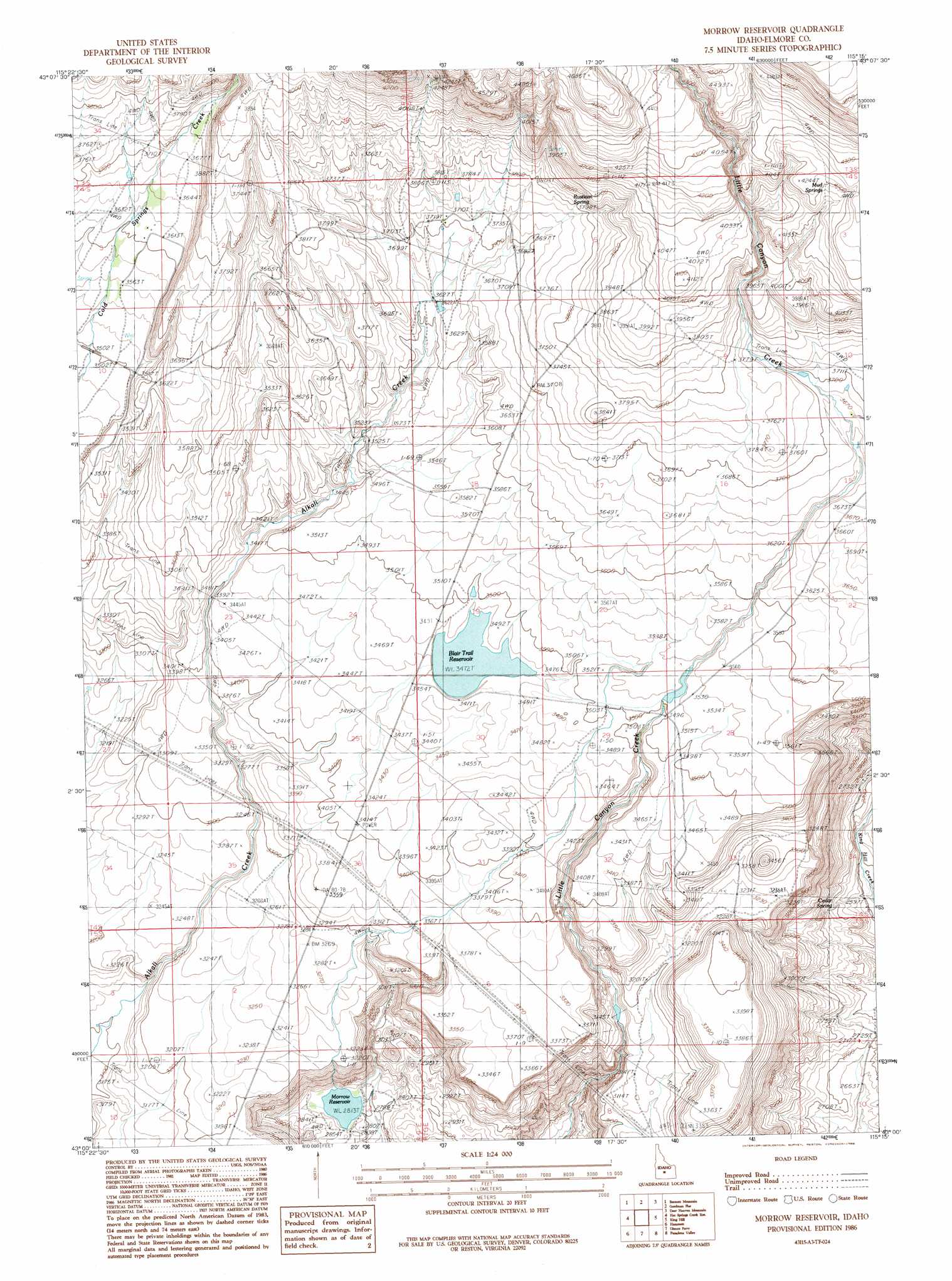
USGS Topo Quad 43115a3 - 1:24,000 scale
| Topo Map Name: | Morrow Reservoir |
| USGS Topo Quad ID: | 43115a3 |
| Print Size: | ca. 21 1/4" wide x 27" high |
| Southeast Coordinates: | 43° N latitude / 115.25° W longitude |
| Map Center Coordinates: | 43.0625° N latitude / 115.3125° W longitude |
| U.S. State: | ID |
| Filename: | o43115a3.jpg |
| Download Map JPG Image: | Morrow Reservoir topo map 1:24,000 scale |
| Map Type: | Topographic |
| Topo Series: | 7.5´ |
| Map Scale: | 1:24,000 |
| Source of Map Images: | United States Geological Survey (USGS) |
| Alternate Map Versions: |
Morrow Reservoir ID 1986, updated 1986 Download PDF Buy paper map Morrow Reservoir ID 2010 Download PDF Buy paper map Morrow Reservoir ID 2013 Download PDF Buy paper map |
1:24,000 Topo Quads surrounding Morrow Reservoir
Long Tom Reservoir |
Anderson Ranch Dam |
Cat Creek Summit |
High Prairie |
Hill City |
Teapot Dome |
Bennett Mountain |
Goodman Flat |
Deer Haven Mountain |
Dempsey Meadows |
Reverse |
Hot Springs Creek Reservoir |
Morrow Reservoir |
King Hill |
Hog Creek |
Indian Cove |
Hammett |
Glenns Ferry |
Pasadena Valley |
Ticeska |
Pence Butte |
Pot Hole Canyon |
Grindstone Butte |
Twentymile Butte |
Indian Butte |
> Back to 43115a1 at 1:100,000 scale
> Back to 43114a1 at 1:250,000 scale
> Back to U.S. Topo Maps home
Morrow Reservoir topo map: Gazetteer
Morrow Reservoir: Areas
The Cottonwoods elevation 1054m 3458′Morrow Reservoir: Dams
Little Canyon Dam elevation 858m 2814′Trail Dam elevation 1055m 3461′
Trail Diversion Dam elevation 1069m 3507′
Morrow Reservoir: Populated Places
Emigrant Crossing elevation 1055m 3461′Morrow Reservoir: Reservoirs
Blair Trail Reservoir elevation 1061m 3480′Morrow Reservoir elevation 858m 2814′
Morrow Reservoir: Springs
Cedar Spring elevation 816m 2677′Latty Hot Spring elevation 1172m 3845′
Mud Springs elevation 1258m 4127′
Rustican Spring elevation 1158m 3799′
Morrow Reservoir digital topo map on disk
Buy this Morrow Reservoir topo map showing relief, roads, GPS coordinates and other geographical features, as a high-resolution digital map file on DVD: