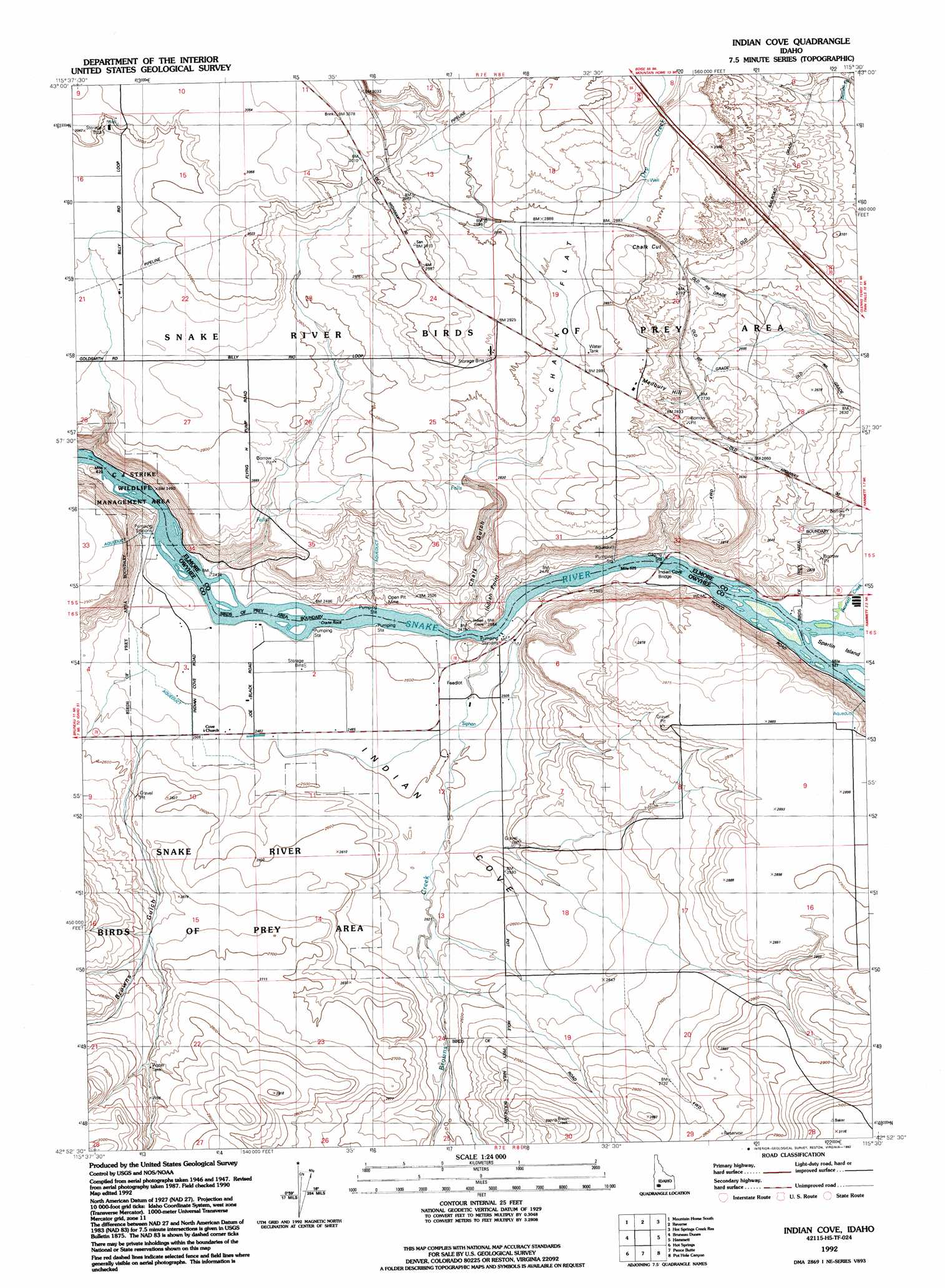
Indian Cove Topo Map Idaho
To zoom in, hover over the map of Indian Cove
USGS Topo Quad 42115h5 - 1:24,000 scale
| Topo Map Name: | Indian Cove |
| USGS Topo Quad ID: | 42115h5 |
| Print Size: | ca. 21 1/4" wide x 27" high |
| Southeast Coordinates: | 42.875° N latitude / 115.5° W longitude |
| Map Center Coordinates: | 42.9375° N latitude / 115.5625° W longitude |
| U.S. State: | ID |
| Filename: | o42115h5.jpg |
| Download Map JPG Image: | Indian Cove topo map 1:24,000 scale |
| Map Type: | Topographic |
| Topo Series: | 7.5´ |
| Map Scale: | 1:24,000 |
| Source of Map Images: | United States Geological Survey (USGS) |
| Alternate Map Versions: |
Indian Cove ID 1947, updated 1963 Download PDF Buy paper map Indian Cove ID 1947, updated 1975 Download PDF Buy paper map Indian Cove ID 1947, updated 1978 Download PDF Buy paper map Indian Cove ID 1947, updated 1986 Download PDF Buy paper map Indian Cove ID 1948 Download PDF Buy paper map Indian Cove ID 1992, updated 1992 Download PDF Buy paper map Indian Cove ID 2010 Download PDF Buy paper map Indian Cove ID 2013 Download PDF Buy paper map |
1:24,000 Topo Quads surrounding Indian Cove
Crater Rings |
Mountain Home North |
Teapot Dome |
Bennett Mountain |
Goodman Flat |
Crater Rings Se |
Mountain Home South |
Reverse |
Hot Springs Creek Reservoir |
Morrow Reservoir |
Bruneau |
Bruneau Dunes |
Indian Cove |
Hammett |
Glenns Ferry |
Sugar Valley |
Hot Spring |
Pence Butte |
Pot Hole Canyon |
Grindstone Butte |
Broken Wagon Flat |
Crowbar Gulch |
Pot Hole Butte |
Black Butte West |
Black Butte East |
> Back to 42115e1 at 1:100,000 scale
> Back to 42114a1 at 1:250,000 scale
> Back to U.S. Topo Maps home
Indian Cove topo map: Gazetteer
Indian Cove: Bridges
Indian Cove Bridge elevation 752m 2467′Indian Cove: Capes
Indian Point elevation 800m 2624′Indian Cove: Flats
Chalk Flat elevation 876m 2874′Indian Cove: Pillars
Crane Rock elevation 752m 2467′Indian Cove: Populated Places
Chalk Cut elevation 868m 2847′Indian Cove: Springs
Commerford Springs elevation 798m 2618′Indian Cove: Streams
Bennett Creek elevation 753m 2470′Browns Creek elevation 785m 2575′
Browns Creek elevation 754m 2473′
Dry Creek elevation 870m 2854′
Indian Cove: Summits
Medbury Hill elevation 870m 2854′Indian Cove: Valleys
Browns Gulch elevation 777m 2549′Chalk Gulch elevation 754m 2473′
Indian Cove elevation 756m 2480′
Indian Cove digital topo map on disk
Buy this Indian Cove topo map showing relief, roads, GPS coordinates and other geographical features, as a high-resolution digital map file on DVD: