North Fork Topo Map Oregon
To zoom in, hover over the map of North Fork
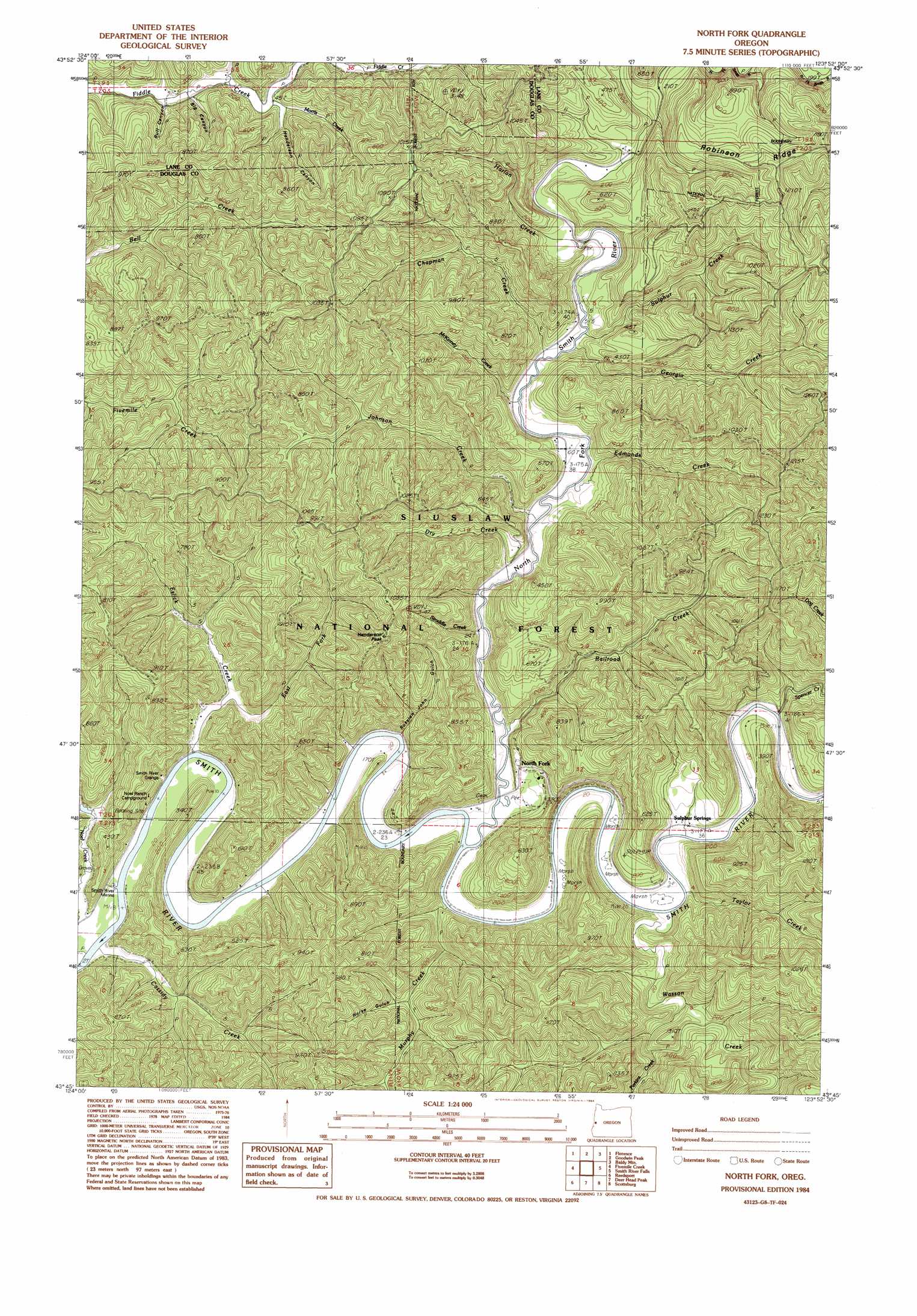
USGS Topo Quad 43123g8 - 1:24,000 scale
| Topo Map Name: | North Fork |
| USGS Topo Quad ID: | 43123g8 |
| Print Size: | ca. 21 1/4" wide x 27" high |
| Southeast Coordinates: | 43.75° N latitude / 123.875° W longitude |
| Map Center Coordinates: | 43.8125° N latitude / 123.9375° W longitude |
| U.S. State: | OR |
| Filename: | o43123g8.jpg |
| Download Map JPG Image: | North Fork topo map 1:24,000 scale |
| Map Type: | Topographic |
| Topo Series: | 7.5´ |
| Map Scale: | 1:24,000 |
| Source of Map Images: | United States Geological Survey (USGS) |
| Alternate Map Versions: |
North Fork OR 1984, updated 1984 Download PDF Buy paper map North Fork OR 2011 Download PDF Buy paper map North Fork OR 2014 Download PDF Buy paper map |
| FStopo: | US Forest Service topo North Fork is available: Download FStopo PDF Download FStopo TIF |
1:24,000 Topo Quads surrounding North Fork
Mercer Lake |
Tiernan |
Mapleton |
Greenleaf |
|
Goose Pasture |
Florence |
Goodwin Peak |
Baldy Mountain |
Roman Nose Mountain |
Tahkenitch Creek |
Fivemile Creek |
North Fork |
Smith River Falls |
Twin Sisters |
Winchester Bay |
Reedsport |
Deer Head Point |
Scottsburg |
Devils Graveyard |
Lakeside |
Trail Butte |
Eck Peak |
Loon Lake |
Old Blue |
> Back to 43123e1 at 1:100,000 scale
> Back to 43122a1 at 1:250,000 scale
> Back to U.S. Topo Maps home
North Fork topo map: Gazetteer
North Fork: Populated Places
North Fork elevation 53m 173′North Fork: Post Offices
Norfolk Post Office (historical) elevation 27m 88′Sulphur Springs Post Office (historical) elevation 12m 39′
Wroe Post Office (historical) elevation 13m 42′
North Fork: Ridges
Robinson Ridge elevation 297m 974′Sulphur Ridge elevation 213m 698′
North Fork: Streams
Billy Moore Creek elevation 13m 42′Cassidy Creek elevation 4m 13′
Chapman Creek elevation 5m 16′
Dry Creek elevation 5m 16′
East Fork Eslick Creek elevation 5m 16′
Edmonds Creek elevation 6m 19′
Eslick Creek elevation 4m 13′
Georgia Creek elevation 6m 19′
Harlan Creek elevation 14m 45′
Johnson Creek elevation 8m 26′
McKinney Creek elevation 7m 22′
Morris Creek elevation 17m 55′
Morris Creek elevation 16m 52′
Murphy Creek elevation 16m 52′
Noel Creek elevation 4m 13′
North Fork Smith River elevation 9m 29′
Perkins Creek elevation 30m 98′
Railroad Creek elevation 4m 13′
Spencer Creek elevation 9m 29′
Straddle Creek elevation 6m 19′
Sulphur Creek elevation 219m 718′
Taylor Creek elevation 83m 272′
Wasson Creek elevation 5m 16′
North Fork: Summits
Buzzards Butte elevation 220m 721′Henderson Peak elevation 342m 1122′
North Fork: Valleys
Big Canyon elevation 19m 62′Bull Canyon elevation 13m 42′
Henderson Canyon elevation 34m 111′
Horse Gulch elevation 82m 269′
Russian John Gulch elevation 8m 26′
North Fork digital topo map on disk
Buy this North Fork topo map showing relief, roads, GPS coordinates and other geographical features, as a high-resolution digital map file on DVD: