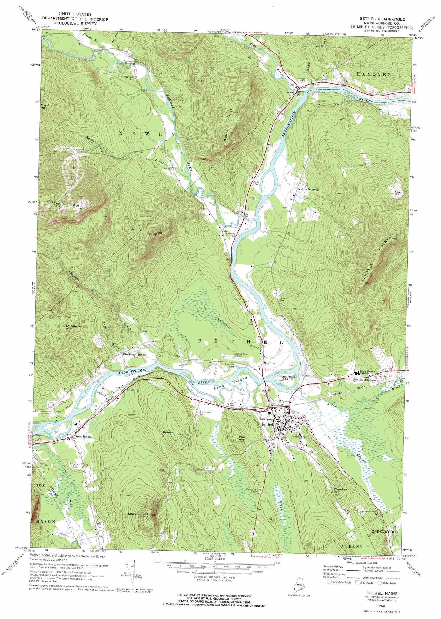
Bethel Topo Map Maine
To zoom in, hover over the map of Bethel
USGS Topo Quad 44070d7 - 1:24,000 scale
| Topo Map Name: | Bethel |
| USGS Topo Quad ID: | 44070d7 |
| Print Size: | ca. 21 1/4" wide x 27" high |
| Southeast Coordinates: | 44.375° N latitude / 70.75° W longitude |
| Map Center Coordinates: | 44.4375° N latitude / 70.8125° W longitude |
| U.S. State: | ME |
| Filename: | o44070d7.jpg |
| Download Map JPG Image: | Bethel topo map 1:24,000 scale |
| Map Type: | Topographic |
| Topo Series: | 7.5´ |
| Map Scale: | 1:24,000 |
| Source of Map Images: | United States Geological Survey (USGS) |
| Alternate Map Versions: |
Bethel ME 1970, updated 1972 Download PDF Buy paper map Bethel ME 1970, updated 1987 Download PDF Buy paper map Bethel ME 1995, updated 2000 Download PDF Buy paper map Bethel ME 2012 Download PDF Buy paper map Bethel ME 2014 Download PDF Buy paper map |
| FStopo: | US Forest Service topo Bethel is available: Download FStopo PDF Download FStopo TIF |
1:24,000 Topo Quads surrounding Bethel
Umbagog Lake South |
B Pond |
Andover |
Ellis Pond |
Roxbury |
Success Pond |
Old Speck Mountain |
Puzzle Mountain |
East Andover |
Rumford |
Shelburne |
Gilead |
Bethel |
Bryant Pond |
Mount Zircon |
Wild River |
Speckled Mountain |
East Stoneham |
Greenwood |
West Paris |
Chatham |
Center Lovell |
North Waterford |
Ralph |
Norway |
> Back to 44070a1 at 1:100,000 scale
> Back to 44070a1 at 1:250,000 scale
> Back to U.S. Topo Maps home
Bethel topo map: Gazetteer
Bethel: Airports
Bethel Regional Airport elevation 201m 659′Bethel: Bridges
Sunday River Bridge elevation 207m 679′Bethel: Islands
Bond Island elevation 194m 636′Hastings Island elevation 195m 639′
Bethel: Parks
Broad Street Historic District elevation 222m 728′Bethel: Populated Places
Bethel elevation 221m 725′Mayville elevation 196m 643′
Middle Intervale elevation 203m 666′
Newry elevation 195m 639′
North Bethel elevation 375m 1230′
Northwest Bethel elevation 221m 725′
West Bethel elevation 207m 679′
Bethel: Streams
Alder River elevation 195m 639′Barkers Brook elevation 195m 639′
Bear River elevation 189m 620′
Chandler Brook elevation 195m 639′
Chapman Brook elevation 189m 620′
Kendall Brook elevation 194m 636′
Lanes Brook elevation 195m 639′
Mill Brook elevation 189m 620′
Simons Brook elevation 213m 698′
Stony Brook elevation 192m 629′
Sunday River elevation 189m 620′
Twitchell Brook elevation 190m 623′
Bethel: Summits
Barker Mountain elevation 786m 2578′Ellingwood Mountain elevation 477m 1564′
Farwell Mountain elevation 575m 1886′
Locke Mountain elevation 580m 1902′
Merrill Hill elevation 572m 1876′
Mount Will elevation 526m 1725′
Paradise Hill elevation 298m 977′
Pine Hill elevation 265m 869′
Robinson Hill elevation 282m 925′
Sparrowhawk Mountain elevation 440m 1443′
Swan Hill elevation 403m 1322′
Bethel digital topo map on disk
Buy this Bethel topo map showing relief, roads, GPS coordinates and other geographical features, as a high-resolution digital map file on DVD:
Maine, New Hampshire, Rhode Island & Eastern Massachusetts
Buy digital topo maps: Maine, New Hampshire, Rhode Island & Eastern Massachusetts