New Vineyard Topo Map Maine
To zoom in, hover over the map of New Vineyard
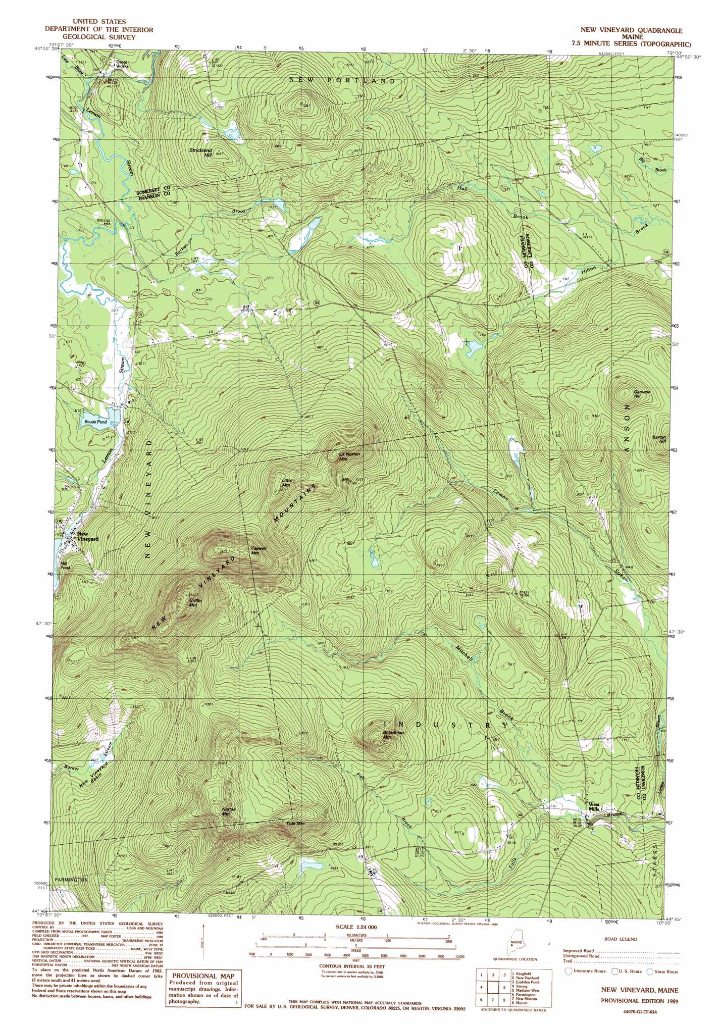
USGS Topo Quad 44070g1 - 1:24,000 scale
| Topo Map Name: | New Vineyard |
| USGS Topo Quad ID: | 44070g1 |
| Print Size: | ca. 21 1/4" wide x 27" high |
| Southeast Coordinates: | 44.75° N latitude / 70° W longitude |
| Map Center Coordinates: | 44.8125° N latitude / 70.0625° W longitude |
| U.S. State: | ME |
| Filename: | o44070g1.jpg |
| Download Map JPG Image: | New Vineyard topo map 1:24,000 scale |
| Map Type: | Topographic |
| Topo Series: | 7.5´ |
| Map Scale: | 1:24,000 |
| Source of Map Images: | United States Geological Survey (USGS) |
| Alternate Map Versions: |
New Vineyard ME 1979, updated 1983 Download PDF Buy paper map New Vineyard ME 1989, updated 1989 Download PDF Buy paper map New Vineyard ME 2011 Download PDF Buy paper map New Vineyard ME 2014 Download PDF Buy paper map |
1:24,000 Topo Quads surrounding New Vineyard
Sugarloaf Mountain |
Poplar Mountain |
Witham Mountain |
Bingham |
Mahoney Hill |
Mount Abraham |
Kingfield |
New Portland |
Embden Pond |
Solon |
Phillips |
Strong |
New Vineyard |
Madison West |
Madison East |
Mount Blue |
Farmington |
New Sharon |
Mercer |
Norridgewock |
East Dixfield |
Wilton |
Farmington Falls |
Belgrade Lakes |
Rome |
> Back to 44070e1 at 1:100,000 scale
> Back to 44070a1 at 1:250,000 scale
> Back to U.S. Topo Maps home
New Vineyard topo map: Gazetteer
New Vineyard: Basins
New Vineyard Basin elevation 215m 705′New Vineyard: Dams
Bauds Pond Dam elevation 169m 554′New Vineyard: Populated Places
New Vineyard elevation 187m 613′West Mills elevation 158m 518′
New Vineyard: Post Offices
New Vineyard Post Office elevation 189m 620′New Vineyard: Reservoirs
Bauds Pond elevation 169m 554′Mill Pond elevation 187m 613′
New Vineyard: Streams
Barker Brook elevation 166m 544′Fish Brook elevation 218m 715′
Greenwood Brook elevation 128m 419′
Greenwood Stream elevation 127m 416′
Hall Brook elevation 127m 416′
Luce Brook elevation 163m 534′
Mitchell Brook elevation 157m 515′
New Vineyard: Summits
Boardman Mountain elevation 442m 1450′Caswell Mountain elevation 611m 2004′
Gamape Hill elevation 388m 1272′
Griffin Mountain elevation 639m 2096′
Ick Norton Mountain elevation 511m 1676′
Little Mountain elevation 523m 1715′
New Vineyard Mountains elevation 492m 1614′
Norton Mountain elevation 558m 1830′
Strickland Hill elevation 305m 1000′
True Mountain elevation 480m 1574′
New Vineyard digital topo map on disk
Buy this New Vineyard topo map showing relief, roads, GPS coordinates and other geographical features, as a high-resolution digital map file on DVD:
Maine, New Hampshire, Rhode Island & Eastern Massachusetts
Buy digital topo maps: Maine, New Hampshire, Rhode Island & Eastern Massachusetts