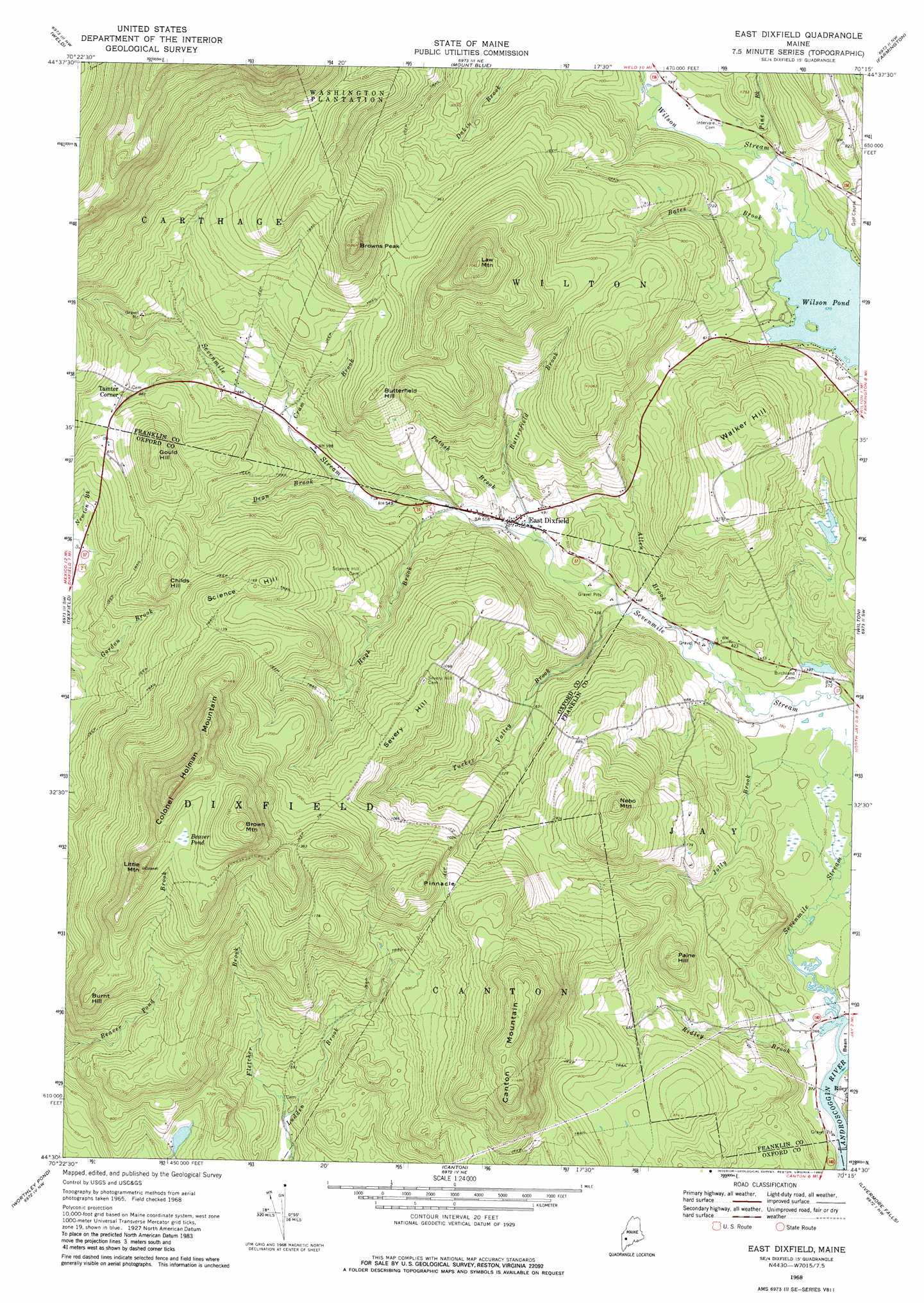
East Dixfield Topo Map Maine
To zoom in, hover over the map of East Dixfield
USGS Topo Quad 44070e3 - 1:24,000 scale
| Topo Map Name: | East Dixfield |
| USGS Topo Quad ID: | 44070e3 |
| Print Size: | ca. 21 1/4" wide x 27" high |
| Southeast Coordinates: | 44.5° N latitude / 70.25° W longitude |
| Map Center Coordinates: | 44.5625° N latitude / 70.3125° W longitude |
| U.S. State: | ME |
| Filename: | o44070e3.jpg |
| Download Map JPG Image: | East Dixfield topo map 1:24,000 scale |
| Map Type: | Topographic |
| Topo Series: | 7.5´ |
| Map Scale: | 1:24,000 |
| Source of Map Images: | United States Geological Survey (USGS) |
| Alternate Map Versions: |
East Dixfield ME 1968, updated 1970 Download PDF Buy paper map East Dixfield ME 1968, updated 1980 Download PDF Buy paper map East Dixfield ME 2011 Download PDF Buy paper map East Dixfield ME 2014 Download PDF Buy paper map |
1:24,000 Topo Quads surrounding East Dixfield
Jackson Mountain |
Madrid |
Phillips |
Strong |
New Vineyard |
Roxbury |
Weld |
Mount Blue |
Farmington |
New Sharon |
Rumford |
Dixfield |
East Dixfield |
Wilton |
Farmington Falls |
Mount Zircon |
Worthley Pond |
Canton |
Livermore Falls |
Fayette |
West Paris |
West Sumner |
Buckfield |
Turner Center |
Wayne |
> Back to 44070e1 at 1:100,000 scale
> Back to 44070a1 at 1:250,000 scale
> Back to U.S. Topo Maps home
East Dixfield topo map: Gazetteer
East Dixfield: Lakes
Wilson Pond elevation 174m 570′East Dixfield: Populated Places
East Dixfield elevation 147m 482′Tainter Corner elevation 267m 875′
East Dixfield: Streams
Allen Brook elevation 121m 396′Bates Brook elevation 174m 570′
Butterfield Brook elevation 145m 475′
Cram Brook elevation 184m 603′
Dean Brook elevation 169m 554′
Fletcher Brook elevation 146m 479′
Hugh Brook elevation 162m 531′
Jolly Brook elevation 108m 354′
Pine Brook elevation 176m 577′
Potash Brook elevation 142m 465′
Ridley Brook elevation 107m 351′
Sevenmile Stream elevation 107m 351′
Tucker Valley Brook elevation 126m 413′
Wilson Stream elevation 174m 570′
East Dixfield: Summits
Brown Mountain elevation 555m 1820′Browns Peak elevation 454m 1489′
Burnt Hill elevation 402m 1318′
Butterfield Hill elevation 332m 1089′
Canton Mountain elevation 472m 1548′
Childs Hill elevation 357m 1171′
Colonel Holman Mountain elevation 561m 1840′
Gould Hill elevation 378m 1240′
Law Mountain elevation 502m 1646′
Little Mountain elevation 500m 1640′
Nebo Mountain elevation 375m 1230′
Paine Hill elevation 293m 961′
Pinnacle elevation 410m 1345′
Science Hill elevation 365m 1197′
Severy Hill elevation 358m 1174′
Walker Hill elevation 310m 1017′
East Dixfield: Swamps
Beaver Pond elevation 442m 1450′East Dixfield digital topo map on disk
Buy this East Dixfield topo map showing relief, roads, GPS coordinates and other geographical features, as a high-resolution digital map file on DVD:
Maine, New Hampshire, Rhode Island & Eastern Massachusetts
Buy digital topo maps: Maine, New Hampshire, Rhode Island & Eastern Massachusetts