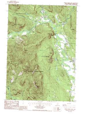
North Conway West Topo Map New Hampshire
To zoom in, hover over the map of North Conway West
USGS Topo Quad 44071a2 - 1:24,000 scale
| Topo Map Name: | North Conway West |
| USGS Topo Quad ID: | 44071a2 |
| Print Size: | ca. 21 1/4" wide x 27" high |
| Southeast Coordinates: | 44° N latitude / 71.125° W longitude |
| Map Center Coordinates: | 44.0625° N latitude / 71.1875° W longitude |
| U.S. State: | NH |
| Filename: | o44071a2.jpg |
| Download Map JPG Image: | North Conway West topo map 1:24,000 scale |
| Map Type: | Topographic |
| Topo Series: | 7.5´ |
| Map Scale: | 1:24,000 |
| Source of Map Images: | United States Geological Survey (USGS) |
| Alternate Map Versions: |
North Conway West NH 1987, updated 1987 Download PDF Buy paper map North Conway West NH 1987, updated 1987 Download PDF Buy paper map North Conway West NH 1995, updated 2000 Download PDF Buy paper map North Conway West NH 2012 Download PDF Buy paper map North Conway West NH 2015 Download PDF Buy paper map |
| FStopo: | US Forest Service topo North Conway West is available: Download FStopo PDF Download FStopo TIF |
1:24,000 Topo Quads surrounding North Conway West
> Back to 44071a1 at 1:100,000 scale
> Back to 44070a1 at 1:250,000 scale
> Back to U.S. Topo Maps home
North Conway West topo map: Gazetteer
North Conway West: Airports
Forbes Heliport elevation 153m 501′North Conway West: Benches
Cathedra Ledge elevation 337m 1105′Humphreys Ledge elevation 221m 725′
White Horse Ledge elevation 412m 1351′
Whites Ledge elevation 322m 1056′
North Conway West: Bridges
Albany Bridge elevation 266m 872′Bartlett Bridge elevation 170m 557′
North Conway West: Dams
Meadow Pond Dam elevation 230m 754′North Conway West: Falls
Thompson Falls elevation 246m 807′North Conway West: Lakes
Echo Lake elevation 145m 475′Kittredge Pond elevation 198m 649′
North Conway West: Parks
Echo Lake-Cathedral Ledge State Park elevation 267m 875′North Conway West: Pillars
Haystack elevation 595m 1952′North Conway West: Populated Places
Cooks Crossing elevation 189m 620′Glen elevation 167m 547′
Intervale elevation 169m 554′
Jericho elevation 181m 593′
Lower Bartlett elevation 173m 567′
North Conway elevation 160m 524′
Rogers Crossing elevation 195m 639′
North Conway West: Post Offices
Intervale Post Office elevation 167m 547′North Conway West: Reservoirs
Meadow Pond elevation 230m 754′North Conway West: Ridges
Red Ridge elevation 660m 2165′North Conway West: Springs
Dianas Baths elevation 271m 889′North Conway West: Streams
Cow Brook elevation 175m 574′Deer Brook elevation 291m 954′
East Branch Saco River elevation 155m 508′
Ellis River elevation 158m 518′
Elm Brook elevation 140m 459′
Gardiner Brook elevation 242m 793′
Kearsarge Brook elevation 139m 456′
Lucy Brook elevation 146m 479′
Mountain Brook elevation 169m 554′
Rocky Branch elevation 168m 551′
Stony Brook elevation 181m 593′
Whitten Brook elevation 231m 757′
North Conway West: Summits
Big Attitash Mountain elevation 885m 2903′Birch Hill elevation 231m 757′
Little Attitash Mountain elevation 760m 2493′
Middle Moat Mountain elevation 840m 2755′
Mount Pickering elevation 583m 1912′
Mount Stanton elevation 510m 1673′
Mount Surprise elevation 271m 889′
North Moat Mountain elevation 956m 3136′
South Moat Mountain elevation 828m 2716′
Spruce Hill elevation 334m 1095′
Thorn Hill elevation 425m 1394′
North Conway West: Trails
Attitash Trail elevation 834m 2736′Bruce Path elevation 267m 875′
Cow Brook Trail elevation 418m 1371′
Humphreys Ledge Trail elevation 481m 1578′
Lucy Brook Trail elevation 746m 2447′
Moat Mountain Trail elevation 330m 1082′
Red Ridge Trail elevation 265m 869′
White Horse Trail elevation 229m 751′
North Conway West digital topo map on disk
Buy this North Conway West topo map showing relief, roads, GPS coordinates and other geographical features, as a high-resolution digital map file on DVD:
Maine, New Hampshire, Rhode Island & Eastern Massachusetts
Buy digital topo maps: Maine, New Hampshire, Rhode Island & Eastern Massachusetts


