Kezar Falls Topo Map Maine
To zoom in, hover over the map of Kezar Falls
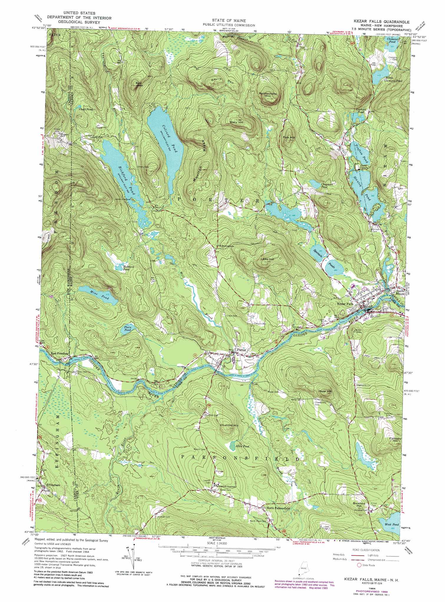
USGS Topo Quad 43070g8 - 1:24,000 scale
| Topo Map Name: | Kezar Falls |
| USGS Topo Quad ID: | 43070g8 |
| Print Size: | ca. 21 1/4" wide x 27" high |
| Southeast Coordinates: | 43.75° N latitude / 70.875° W longitude |
| Map Center Coordinates: | 43.8125° N latitude / 70.9375° W longitude |
| U.S. States: | ME, NH |
| Filename: | o43070g8.jpg |
| Download Map JPG Image: | Kezar Falls topo map 1:24,000 scale |
| Map Type: | Topographic |
| Topo Series: | 7.5´ |
| Map Scale: | 1:24,000 |
| Source of Map Images: | United States Geological Survey (USGS) |
| Alternate Map Versions: |
Kezar Falls ME 1964, updated 1966 Download PDF Buy paper map Kezar Falls ME 1964, updated 1975 Download PDF Buy paper map Kezar Falls ME 1964, updated 1989 Download PDF Buy paper map Kezar Falls ME 1964, updated 1989 Download PDF Buy paper map Kezar Falls ME 2011 Download PDF Buy paper map Kezar Falls ME 2014 Download PDF Buy paper map |
1:24,000 Topo Quads surrounding Kezar Falls
North Conway West |
North Conway East |
Fryeburg |
Pleasant Mountain |
Bridgton |
Silver Lake |
Conway |
Brownfield |
Hiram |
North Sebago |
Ossipee Lake |
Freedom |
Kezar Falls |
Cornish |
Steep Falls |
Tuftonboro |
Ossipee |
West Newfield |
Limerick |
Limington |
Wolfeboro |
Sanbornville |
Great East Lake |
Mousam Lake |
Waterboro |
> Back to 43070e1 at 1:100,000 scale
> Back to 43070a1 at 1:250,000 scale
> Back to U.S. Topo Maps home
Kezar Falls topo map: Gazetteer
Kezar Falls: Bridges
Porter-Parsonfield Bridge elevation 111m 364′Kezar Falls: Dams
Bickford Pond Dam elevation 141m 462′Black Lake Dam elevation 119m 390′
Colcord Pond Dam elevation 162m 531′
Kezar Falls Dam elevation 105m 344′
Kezar Falls Upper Dam elevation 109m 357′
Mill Pond Dam elevation 117m 383′
Stanley Pond Dam elevation 117m 383′
Kezar Falls: Islands
John J Island elevation 141m 462′Kezar Falls: Lakes
Allen Pond elevation 153m 501′Chalk Pond elevation 188m 616′
Chapman Pond elevation 157m 515′
Hubbard Pond elevation 185m 606′
Jaybird Pond elevation 124m 406′
Little Clemons Pond elevation 125m 410′
Mine Pond elevation 155m 508′
Plain Pond elevation 121m 396′
Spectacle Ponds elevation 116m 380′
Trafton Pond elevation 117m 383′
Kezar Falls: Populated Places
East Freedom elevation 125m 410′Effingham elevation 183m 600′
Kezar Falls elevation 116m 380′
North Parsonsfield elevation 167m 547′
Porter elevation 125m 410′
South Hiram elevation 116m 380′
Kezar Falls: Reservoirs
Bickford Pond elevation 141m 462′Black Lake elevation 119m 390′
Colcord Pond elevation 162m 531′
Ossipee River Reservoir elevation 105m 344′
Ossipee River Reservoir elevation 109m 357′
Ridlon Brook elevation 117m 383′
Stanley Pond elevation 117m 383′
Kezar Falls: Ridges
Moulton Ridge elevation 302m 990′Kezar Falls: Streams
Great Brook elevation 111m 364′Mill Brook elevation 111m 364′
Mill Brook elevation 111m 364′
Ridlon Brook elevation 105m 344′
South River elevation 113m 370′
Thurston Brook elevation 141m 462′
Kezar Falls: Summits
Bald Ledge elevation 362m 1187′Bickford Hill elevation 220m 721′
Churchill Hill elevation 209m 685′
Collomy Hill elevation 258m 846′
Devils Den elevation 362m 1187′
Fork Hill elevation 281m 921′
Kezar Hill elevation 272m 892′
Libby Hill elevation 320m 1049′
Rattlesnake Mountain elevation 358m 1174′
Stacy Hill elevation 329m 1079′
Kezar Falls digital topo map on disk
Buy this Kezar Falls topo map showing relief, roads, GPS coordinates and other geographical features, as a high-resolution digital map file on DVD:
Maine, New Hampshire, Rhode Island & Eastern Massachusetts
Buy digital topo maps: Maine, New Hampshire, Rhode Island & Eastern Massachusetts