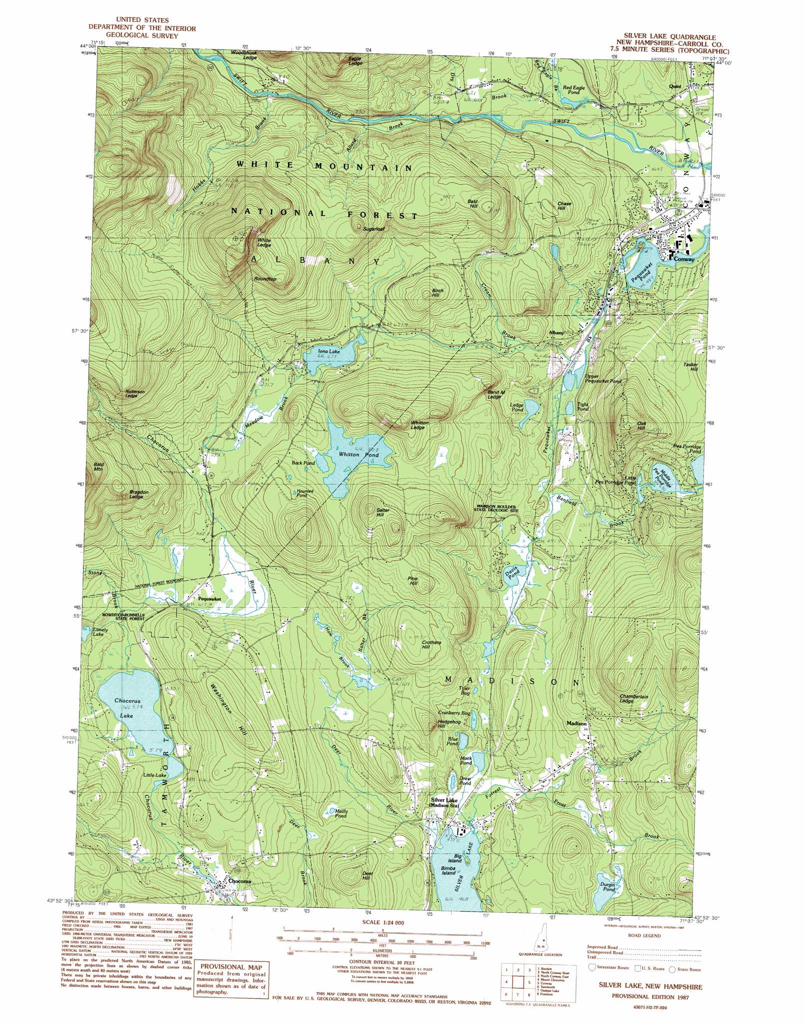
Silver Lake Topo Map New Hampshire
To zoom in, hover over the map of Silver Lake
USGS Topo Quad 43071h2 - 1:24,000 scale
| Topo Map Name: | Silver Lake |
| USGS Topo Quad ID: | 43071h2 |
| Print Size: | ca. 21 1/4" wide x 27" high |
| Southeast Coordinates: | 43.875° N latitude / 71.125° W longitude |
| Map Center Coordinates: | 43.9375° N latitude / 71.1875° W longitude |
| U.S. State: | NH |
| Filename: | o43071h2.jpg |
| Download Map JPG Image: | Silver Lake topo map 1:24,000 scale |
| Map Type: | Topographic |
| Topo Series: | 7.5´ |
| Map Scale: | 1:24,000 |
| Source of Map Images: | United States Geological Survey (USGS) |
| Alternate Map Versions: |
Silver Lake NH 1987, updated 1987 Download PDF Buy paper map Silver Lake NH 1995, updated 2000 Download PDF Buy paper map Silver Lake NH 2012 Download PDF Buy paper map Silver Lake NH 2015 Download PDF Buy paper map |
| FStopo: | US Forest Service topo Silver Lake is available: Download FStopo PDF Download FStopo TIF |
1:24,000 Topo Quads surrounding Silver Lake
Crawford Notch |
Stairs Mountain |
Jackson |
Chatham |
Center Lovell |
Mount Carrigan |
Bartlett |
North Conway West |
North Conway East |
Fryeburg |
Mount Tripyramid |
Mount Chocorua |
Silver Lake |
Conway |
Brownfield |
Center Sandwich |
Tamworth |
Ossipee Lake |
Freedom |
Kezar Falls |
Center Harbor |
Melvin Village |
Tuftonboro |
Ossipee |
West Newfield |
> Back to 43071e1 at 1:100,000 scale
> Back to 43070a1 at 1:250,000 scale
> Back to U.S. Topo Maps home
Silver Lake topo map: Gazetteer
Silver Lake: Airports
Leavitt Airport elevation 243m 797′Silver Lake: Benches
Band M Ledge elevation 285m 935′Bragdon Ledge elevation 429m 1407′
Chamberlain Ledge elevation 294m 964′
Eagle Ledge elevation 450m 1476′
Nickerson Ledge elevation 466m 1528′
White Ledge elevation 596m 1955′
Whitton Ledge elevation 359m 1177′
Woodchuck Ledge elevation 307m 1007′
Silver Lake: Dams
Chocorua River Dam elevation 159m 521′Little Pea Porridge Pond Dam elevation 199m 652′
Silver Lake: Islands
Big Island elevation 142m 465′Bimba Island elevation 142m 465′
Silver Lake: Lakes
Back Pond elevation 246m 807′Blue Pond elevation 152m 498′
Chocorua Lake elevation 175m 574′
Cranberry Bog elevation 180m 590′
Davis Pond elevation 154m 505′
Drew Pond elevation 149m 488′
Durgin Pond elevation 167m 547′
Haunted Pond elevation 273m 895′
Iona Lake elevation 206m 675′
Ledge Pond elevation 164m 538′
Little Lake elevation 174m 570′
Lonely Lake elevation 192m 629′
Mack Pond elevation 145m 475′
Mailly Pond elevation 170m 557′
Middle Pea Porridge Pond elevation 207m 679′
Red Eagle Pond elevation 164m 538′
Tight Pond elevation 142m 465′
Tyler Bog elevation 171m 561′
Upper Pequawket Pond elevation 144m 472′
Whitton Pond elevation 246m 807′
Silver Lake: Parks
Bowditch-Runnells State Forest elevation 215m 705′Silver Lake: Pillars
Madison Boulder elevation 173m 567′Silver Lake: Populated Places
Albany elevation 190m 623′Chocorua elevation 160m 524′
Madison elevation 175m 574′
Pequawket elevation 189m 620′
Quint elevation 178m 583′
Silver Lake elevation 148m 485′
Silver Lake: Post Offices
Silver Lake Post Office elevation 147m 482′Silver Lake: Reservoirs
Chocorua River Reservoir elevation 159m 521′Little Pea Porridge Pond elevation 199m 652′
Mirror Lake elevation 204m 669′
Silver Lake: Ridges
Washington Hill elevation 281m 921′Silver Lake: Streams
Allard Brook elevation 189m 620′Banfield Brook elevation 152m 498′
Big Brook elevation 247m 810′
Cream Brook elevation 153m 501′
Deer River elevation 144m 472′
Dry Brook elevation 166m 544′
Forrest Brook elevation 143m 469′
Frost Brook elevation 149m 488′
Ham Brook elevation 175m 574′
Hobbs Brook elevation 238m 780′
Meadow Brook elevation 206m 675′
Pequawket Brook elevation 139m 456′
Red Eagle Brook elevation 143m 469′
Salter Brook elevation 188m 616′
Stony Brook elevation 181m 593′
Swift Brook elevation 176m 577′
Silver Lake: Summits
Bald Hill elevation 357m 1171′Birch Hill elevation 289m 948′
Chase Hill elevation 264m 866′
Crothers Hill elevation 258m 846′
Deer Hill elevation 263m 862′
Hedgehog Hill elevation 227m 744′
Oak Hill elevation 354m 1161′
Pine Hill elevation 283m 928′
Roundtop elevation 446m 1463′
Salter Hill elevation 338m 1108′
Sugarloaf elevation 375m 1230′
Tasker Hill elevation 229m 751′
Silver Lake: Swamps
Lovejoy Marsh elevation 218m 715′Silver Lake: Trails
Carter Ledge Trail elevation 469m 1538′Piper Trail elevation 367m 1204′
Weetamoo Trail elevation 346m 1135′
White Ledge Trail elevation 367m 1204′
Silver Lake digital topo map on disk
Buy this Silver Lake topo map showing relief, roads, GPS coordinates and other geographical features, as a high-resolution digital map file on DVD:
Maine, New Hampshire, Rhode Island & Eastern Massachusetts
Buy digital topo maps: Maine, New Hampshire, Rhode Island & Eastern Massachusetts