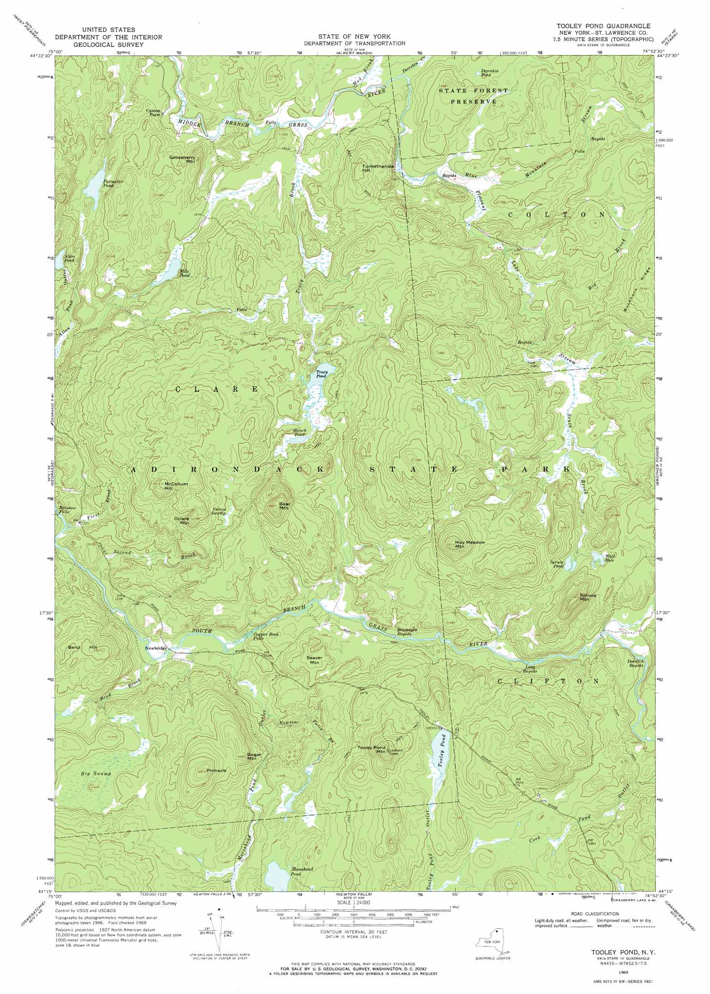
Tooley Pond Topo Map New York
To zoom in, hover over the map of Tooley Pond
USGS Topo Quad 44074c8 - 1:24,000 scale
| Topo Map Name: | Tooley Pond |
| USGS Topo Quad ID: | 44074c8 |
| Print Size: | ca. 21 1/4" wide x 27" high |
| Southeast Coordinates: | 44.25° N latitude / 74.875° W longitude |
| Map Center Coordinates: | 44.3125° N latitude / 74.9375° W longitude |
| U.S. State: | NY |
| Filename: | o44074c8.jpg |
| Download Map JPG Image: | Tooley Pond topo map 1:24,000 scale |
| Map Type: | Topographic |
| Topo Series: | 7.5´ |
| Map Scale: | 1:24,000 |
| Source of Map Images: | United States Geological Survey (USGS) |
| Alternate Map Versions: |
Tooley Pond NY 1969, updated 1971 Download PDF Buy paper map Tooley Pond NY 2010 Download PDF Buy paper map Tooley Pond NY 2013 Download PDF Buy paper map Tooley Pond NY 2016 Download PDF Buy paper map |
1:24,000 Topo Quads surrounding Tooley Pond
Canton |
Pierrepont |
Colton |
Rainbow Falls |
Sylvan Falls |
Hermon |
West Pierrepont |
Albert Marsh |
Stark |
Carry Falls Reservoir |
South Edwards |
Degrasse |
Tooley Pond |
Brother Ponds |
Childwold |
Fine |
Oswegatchie |
Newton Falls |
Cranberry Lake |
|
Oswegatchie Sw |
Oswegatchie Se |
Five Ponds |
Wolf Mountain |
> Back to 44074a1 at 1:100,000 scale
> Back to 44074a1 at 1:250,000 scale
> Back to U.S. Topo Maps home
Tooley Pond topo map: Gazetteer
Tooley Pond: Bays
Wolf Hole elevation 444m 1456′Tooley Pond: Falls
Copper Rock Falls elevation 378m 1240′Rainbow Falls elevation 356m 1167′
Tooley Pond: Lakes
Allen Pond elevation 364m 1194′Deerskin Pond elevation 394m 1292′
Mile Pond elevation 363m 1190′
Moosehead Pond elevation 436m 1430′
Parmeter Pond elevation 350m 1148′
Slouch Pond elevation 419m 1374′
Spruce Pond elevation 448m 1469′
Tooley Pond elevation 459m 1505′
Tracy Pond elevation 417m 1368′
Tooley Pond: Populated Places
Newbridge elevation 372m 1220′Tooley Pond: Rapids
Brumagin Rapids elevation 404m 1325′Deerlick Rapids elevation 415m 1361′
Long Rapids elevation 414m 1358′
Tooley Pond: Streams
Bend Brook elevation 372m 1220′Big Brook elevation 389m 1276′
Blue Mountain Stream elevation 373m 1223′
Deerskin Creek elevation 367m 1204′
First Brook elevation 365m 1197′
Moosehead Pond Outlet elevation 372m 1220′
Mud Brook elevation 360m 1181′
Newton Falls Brook elevation 383m 1256′
Pleasant Lake Stream elevation 373m 1223′
Second Brook elevation 367m 1204′
South Brook elevation 412m 1351′
Tracy Brook elevation 360m 1181′
Tooley Pond: Summits
Bear Mountain elevation 514m 1686′Bend Hill elevation 465m 1525′
Gooseberry Mountain elevation 396m 1299′
Hay Meadow Mountain elevation 533m 1748′
McCollum Hill elevation 491m 1610′
Oclare Mountain elevation 483m 1584′
Pinnacle elevation 513m 1683′
Seaver Mountain elevation 435m 1427′
Spruce Mountain elevation 521m 1709′
Sugar Mountain elevation 483m 1584′
Tooley Pond Mountain elevation 543m 1781′
Tunkethandle Hill elevation 429m 1407′
Tooley Pond: Swamps
Big Swamp elevation 417m 1368′Oclare Swamp elevation 425m 1394′
Tooley Pond digital topo map on disk
Buy this Tooley Pond topo map showing relief, roads, GPS coordinates and other geographical features, as a high-resolution digital map file on DVD:
New York, Vermont, Connecticut & Western Massachusetts
Buy digital topo maps: New York, Vermont, Connecticut & Western Massachusetts