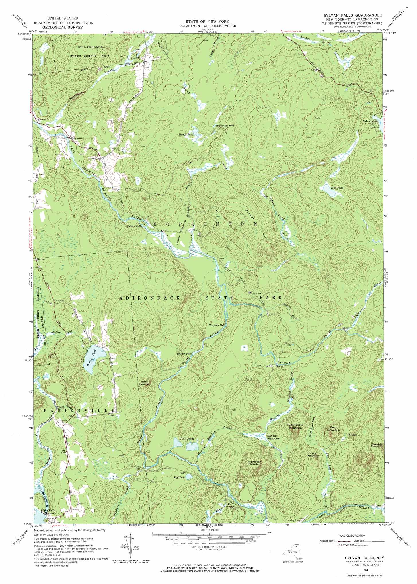
Sylvan Falls Topo Map New York
To zoom in, hover over the map of Sylvan Falls
USGS Topo Quad 44074e6 - 1:24,000 scale
| Topo Map Name: | Sylvan Falls |
| USGS Topo Quad ID: | 44074e6 |
| Print Size: | ca. 21 1/4" wide x 27" high |
| Southeast Coordinates: | 44.5° N latitude / 74.625° W longitude |
| Map Center Coordinates: | 44.5625° N latitude / 74.6875° W longitude |
| U.S. State: | NY |
| Filename: | o44074e6.jpg |
| Download Map JPG Image: | Sylvan Falls topo map 1:24,000 scale |
| Map Type: | Topographic |
| Topo Series: | 7.5´ |
| Map Scale: | 1:24,000 |
| Source of Map Images: | United States Geological Survey (USGS) |
| Alternate Map Versions: |
Sylvan Falls NY 1964, updated 1966 Download PDF Buy paper map Sylvan Falls NY 2010 Download PDF Buy paper map Sylvan Falls NY 2013 Download PDF Buy paper map Sylvan Falls NY 2016 Download PDF Buy paper map |
1:24,000 Topo Quads surrounding Sylvan Falls
Norfolk |
Brasher Falls |
North Lawrence |
Brushton |
Bangor |
Potsdam |
Parishville |
Nicholville |
Saint Regis Falls |
Santa Clara |
Colton |
Rainbow Falls |
Sylvan Falls |
Lake Ozonia |
Meno |
Albert Marsh |
Stark |
Carry Falls Reservoir |
Augerhole Falls |
|
Tooley Pond |
Brother Ponds |
Childwold |
Mount Matumbla |
> Back to 44074e1 at 1:100,000 scale
> Back to 44074a1 at 1:250,000 scale
> Back to U.S. Topo Maps home
Sylvan Falls topo map: Gazetteer
Sylvan Falls: Falls
Bruner Falls elevation 355m 1164′Kingsley Falls elevation 353m 1158′
Sylvan Falls elevation 342m 1122′
Sylvan Falls: Flats
Fenner Meadows elevation 352m 1154′Randle Meadows elevation 407m 1335′
Sylvan Falls: Forests
Saint Lawrence State Forest Number 8 elevation 372m 1220′Sylvan Falls: Gaps
Sugar Grove Pass elevation 425m 1394′Sylvan Falls: Lakes
Hopkinton Pond elevation 387m 1269′Mud Pond elevation 424m 1391′
Slough Pond elevation 381m 1250′
Sterling Pond elevation 385m 1263′
Twin Ponds elevation 403m 1322′
Sylvan Falls: Reservoirs
Blake Falls Reservoir elevation 379m 1243′Sylvan Falls: Streams
Balsam Brook elevation 390m 1279′Dead Creek elevation 360m 1181′
Fenner Meadow Brook elevation 343m 1125′
Hogback Brook elevation 375m 1230′
Mud Pond Outlet elevation 348m 1141′
Randle Meadow Brook elevation 387m 1269′
Randle Meadow Brook elevation 390m 1279′
Santimaw Brook elevation 286m 938′
Sterling Pond Outlet elevation 370m 1213′
Stony Brook elevation 348m 1141′
The Bog Outlet elevation 408m 1338′
Thomas Brook elevation 367m 1204′
Welch Brook elevation 365m 1197′
Willis Brook elevation 403m 1322′
Sylvan Falls: Summits
Bear Mountain elevation 520m 1706′Coffee Mountain elevation 448m 1469′
Flower Hill elevation 457m 1499′
Hamilton Mountain elevation 524m 1719′
Loon Mountain elevation 479m 1571′
Sugar Grove Mountain elevation 510m 1673′
Sylvan Falls: Swamps
The Bog elevation 450m 1476′Sylvan Falls digital topo map on disk
Buy this Sylvan Falls topo map showing relief, roads, GPS coordinates and other geographical features, as a high-resolution digital map file on DVD:
New York, Vermont, Connecticut & Western Massachusetts
Buy digital topo maps: New York, Vermont, Connecticut & Western Massachusetts