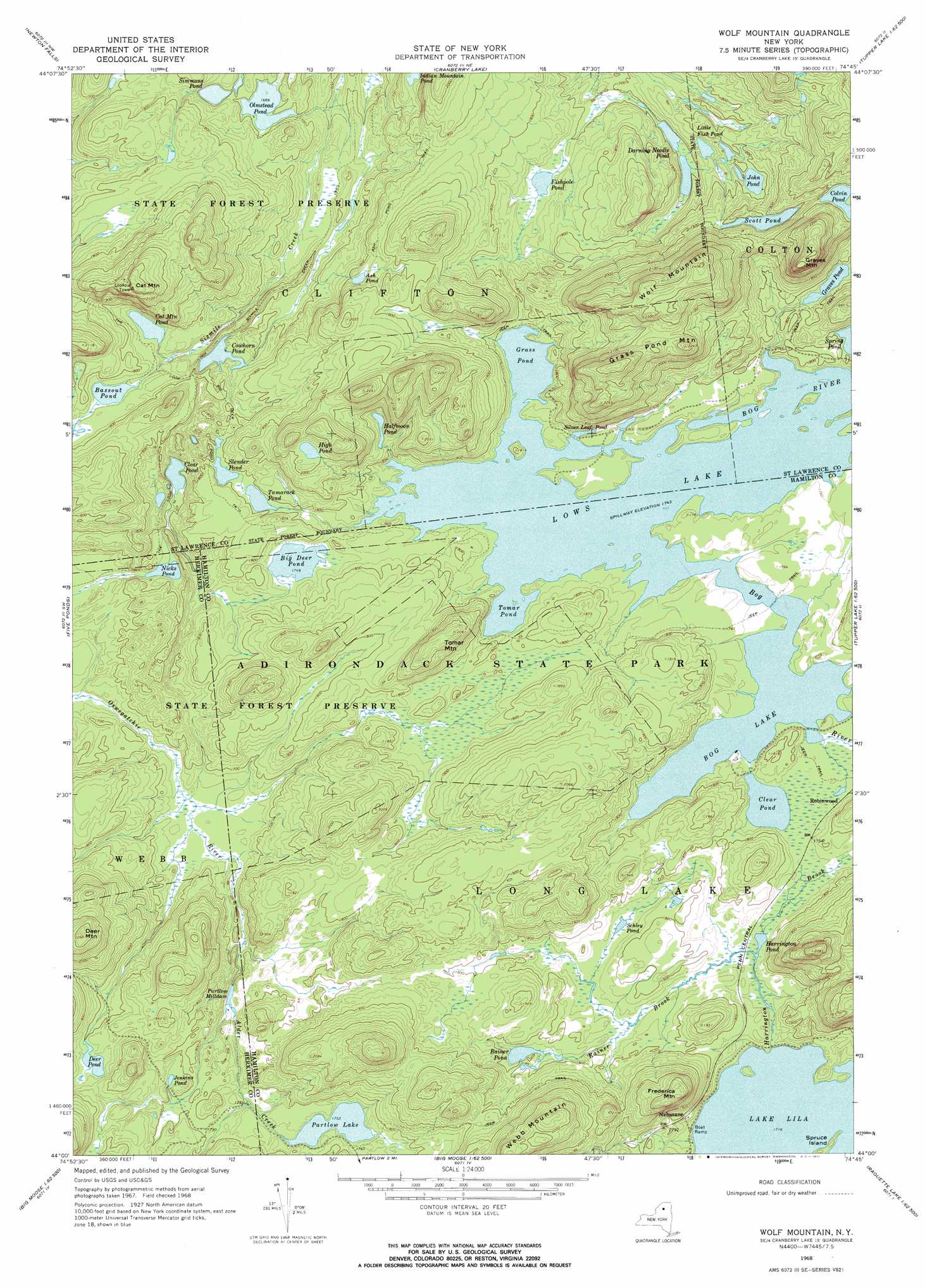
Wolf Mountain Topo Map New York
To zoom in, hover over the map of Wolf Mountain
USGS Topo Quad 44074a7 - 1:24,000 scale
| Topo Map Name: | Wolf Mountain |
| USGS Topo Quad ID: | 44074a7 |
| Print Size: | ca. 21 1/4" wide x 27" high |
| Southeast Coordinates: | 44° N latitude / 74.75° W longitude |
| Map Center Coordinates: | 44.0625° N latitude / 74.8125° W longitude |
| U.S. State: | NY |
| Filename: | o44074a7.jpg |
| Download Map JPG Image: | Wolf Mountain topo map 1:24,000 scale |
| Map Type: | Topographic |
| Topo Series: | 7.5´ |
| Map Scale: | 1:24,000 |
| Source of Map Images: | United States Geological Survey (USGS) |
| Alternate Map Versions: |
Wolf Mountain NY 1968, updated 1971 Download PDF Buy paper map Wolf Mountain NY 1968, updated 1971 Download PDF Buy paper map Wolf Mountain NY 1999, updated 2001 Download PDF Buy paper map Wolf Mountain NY 2010 Download PDF Buy paper map Wolf Mountain NY 2013 Download PDF Buy paper map Wolf Mountain NY 2016 Download PDF Buy paper map |
1:24,000 Topo Quads surrounding Wolf Mountain
Degrasse |
Tooley Pond |
Brother Ponds |
Childwold |
Mount Matumbla |
Oswegatchie |
Newton Falls |
Cranberry Lake |
Pierce Field |
|
Oswegatchie Se |
Five Ponds |
Wolf Mountain |
Slim Pond |
|
Stillwater Reservoir West |
Nehasane Lake |
Forked Lake |
||
Stillwater Mountain |
Eagle Bay |
Sargent Ponds |
> Back to 44074a1 at 1:100,000 scale
> Back to 44074a1 at 1:250,000 scale
> Back to U.S. Topo Maps home
Wolf Mountain topo map: Gazetteer
Wolf Mountain: Islands
Spruce Island elevation 526m 1725′Wolf Mountain: Lakes
Ash Pond elevation 551m 1807′Bassout Pond elevation 535m 1755′
Big Deer Pond elevation 533m 1748′
Bog Lake elevation 531m 1742′
Cat Mountain Pond elevation 527m 1729′
Clear Pond elevation 533m 1748′
Clear Pond elevation 516m 1692′
Colvin Pond elevation 607m 1991′
Cowhorn Pond elevation 529m 1735′
Darning Needle Pond elevation 514m 1686′
Deer Pond elevation 552m 1811′
Fishpole Pond elevation 521m 1709′
Grass Pond elevation 531m 1742′
Graves Pond elevation 541m 1774′
Halfmoon Pond elevation 559m 1833′
Harrington Pond elevation 530m 1738′
High Pond elevation 612m 2007′
Jenkins Pond elevation 554m 1817′
John Pond elevation 544m 1784′
Lake Lila elevation 523m 1715′
Little Fish Pond elevation 533m 1748′
Nicks Pond elevation 503m 1650′
Olmstead Pond elevation 515m 1689′
Partlow Lake elevation 534m 1751′
Partlow Milldam elevation 521m 1709′
Rainer Pond elevation 541m 1774′
Schley Pond elevation 534m 1751′
Scott Pond elevation 578m 1896′
Silver Leaf Pond elevation 535m 1755′
Simmons Pond elevation 517m 1696′
Slender Pond elevation 546m 1791′
Tamarack Pond elevation 545m 1788′
Tomar Pond elevation 531m 1742′
Wolf Mountain: Populated Places
Nehasane elevation 543m 1781′Wolf Mountain: Streams
Harrington Brook elevation 524m 1719′Rainer Brook elevation 531m 1742′
Wolf Mountain: Summits
Cat Mountain elevation 691m 2267′Deer Mountain elevation 689m 2260′
Frederica Mountain elevation 666m 2185′
Grass Pond Mountain elevation 684m 2244′
Graves Mountain elevation 705m 2312′
Tomar Mountain elevation 633m 2076′
Webb Mountain elevation 691m 2267′
Wolf Mountain elevation 732m 2401′
Wolf Mountain: Trails
Ash Pond Trail elevation 550m 1804′Big Deer Pond Trail elevation 557m 1827′
Sixmile Creek Trail elevation 525m 1722′
The Loop elevation 535m 1755′
Wolf Mountain digital topo map on disk
Buy this Wolf Mountain topo map showing relief, roads, GPS coordinates and other geographical features, as a high-resolution digital map file on DVD:
New York, Vermont, Connecticut & Western Massachusetts
Buy digital topo maps: New York, Vermont, Connecticut & Western Massachusetts