Luther Ne Topo Map Michigan
To zoom in, hover over the map of Luther Ne
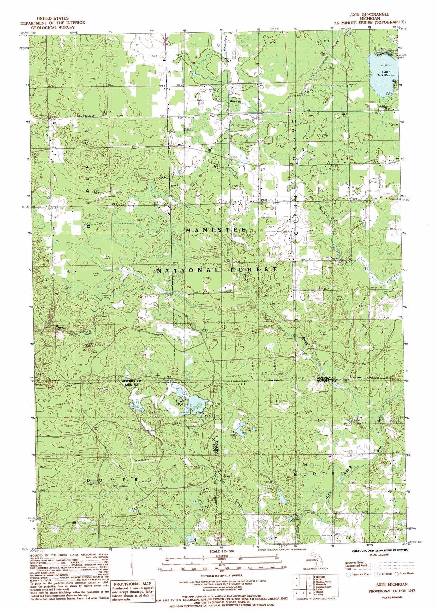
USGS Topo Quad 44085b5 - 1:24,000 scale
| Topo Map Name: | Luther Ne |
| USGS Topo Quad ID: | 44085b5 |
| Print Size: | ca. 21 1/4" wide x 27" high |
| Southeast Coordinates: | 44.125° N latitude / 85.5° W longitude |
| Map Center Coordinates: | 44.1875° N latitude / 85.5625° W longitude |
| U.S. State: | MI |
| Filename: | o44085b5.jpg |
| Download Map JPG Image: | Luther Ne topo map 1:24,000 scale |
| Map Type: | Topographic |
| Topo Series: | 7.5´ |
| Map Scale: | 1:24,000 |
| Source of Map Images: | United States Geological Survey (USGS) |
| Alternate Map Versions: |
Axin MI 1987, updated 1988 Download PDF Buy paper map Axin MI 2012 Download PDF Buy paper map Axin MI 2014 Download PDF Buy paper map Axin MI 2017 Download PDF Buy paper map |
| FStopo: | US Forest Service topo Axin is available: Download FStopo PDF Download FStopo TIF |
1:24,000 Topo Quads surrounding Luther Ne
Harlan |
Mesick |
Mesick Ne |
Manton |
Arlene |
Yuma |
Harrieta |
Boon |
Cadillac North |
Jennings |
Peacock Ne |
Luther Nw |
Luther Ne |
Cadillac South |
Lucas |
Peacock Se |
Luther Sw |
Luther Se |
Le Roy |
Dighton |
Baldwin |
Chase |
Reed City North |
Slaybaugh Corner |
Evart |
> Back to 44085a1 at 1:100,000 scale
> Back to 44084a1 at 1:250,000 scale
> Back to U.S. Topo Maps home
Luther Ne topo map: Gazetteer
Luther Ne: Lakes
Hay Lake elevation 378m 1240′Lake Olga elevation 372m 1220′
Luther Ne: Parks
Mitchell Creek Waterfowl Area elevation 395m 1295′Luther Ne: Populated Places
Axin elevation 406m 1332′Luther Ne: Post Offices
Axin Post Office (historical) elevation 406m 1332′Luther Ne: Streams
Fairchild Creek elevation 357m 1171′Mitchell Creek elevation 393m 1289′
Luther Ne digital topo map on disk
Buy this Luther Ne topo map showing relief, roads, GPS coordinates and other geographical features, as a high-resolution digital map file on DVD: