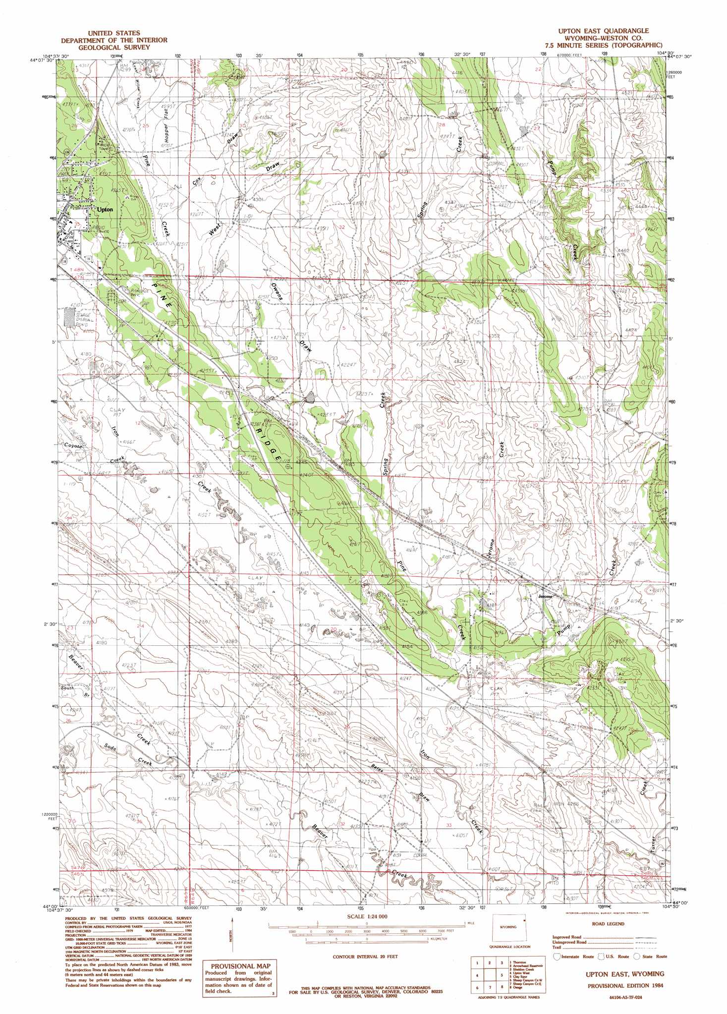
Upton East Topo Map Wyoming
To zoom in, hover over the map of Upton East
USGS Topo Quad 44104a5 - 1:24,000 scale
| Topo Map Name: | Upton East |
| USGS Topo Quad ID: | 44104a5 |
| Print Size: | ca. 21 1/4" wide x 27" high |
| Southeast Coordinates: | 44° N latitude / 104.5° W longitude |
| Map Center Coordinates: | 44.0625° N latitude / 104.5625° W longitude |
| U.S. State: | WY |
| Filename: | o44104a5.jpg |
| Download Map JPG Image: | Upton East topo map 1:24,000 scale |
| Map Type: | Topographic |
| Topo Series: | 7.5´ |
| Map Scale: | 1:24,000 |
| Source of Map Images: | United States Geological Survey (USGS) |
| Alternate Map Versions: |
Upton East WY 1984, updated 1984 Download PDF Buy paper map Upton East WY 2012 Download PDF Buy paper map Upton East WY 2015 Download PDF Buy paper map |
| FStopo: | US Forest Service topo Upton East is available: Download FStopo PDF Download FStopo TIF |
1:24,000 Topo Quads surrounding Upton East
Grasshopper Butte |
Iron Mountain |
Linden |
Pfeiffer Hill |
Duling Hill |
Freda Creek |
Thornton |
Arrowhead Reservoir |
Sheldon Creek |
Inyan Kara Mountain |
Soda Butte |
Upton West |
Upton East |
Clay Spur |
Skull Creek |
West Fork Buffalo Creek |
Sheep Canyon Creek West |
Sheep Canyon Creek East |
Osage |
Pedro |
Wildlife Draw East |
Fairview |
Lassen Creek |
Klodt Reservoir |
Osage Se |
> Back to 44104a1 at 1:100,000 scale
> Back to 44104a1 at 1:250,000 scale
> Back to U.S. Topo Maps home
Upton East topo map: Gazetteer
Upton East: Dams
Bowl Dam elevation 1311m 4301′Upton East: Mines
Beaver Creek Mine elevation 1257m 4124′Jerome Area Mine elevation 1354m 4442′
Owens Draw Mine elevation 1294m 4245′
Pine Ridge Mine elevation 1293m 4242′
Turner Creek Mine elevation 1267m 4156′
Upton Number One elevation 1293m 4242′
Upton East: Populated Places
Jerome elevation 1282m 4206′Upton East: Reservoirs
Bowl Reservoir elevation 1311m 4301′Upton East: Streams
Coyote Creek elevation 1269m 4163′Jerome Creek elevation 1264m 4146′
Lower Willow Creek elevation 1309m 4294′
Pine Creek elevation 1253m 4110′
Pump Creek elevation 1258m 4127′
Soda Creek elevation 1263m 4143′
South Branch Beaver Creek elevation 1270m 4166′
Spring Creek elevation 1269m 4163′
Upton East: Valleys
Bates Draw elevation 1253m 4110′Cox Draw elevation 1301m 4268′
Owens Draw elevation 1279m 4196′
West Draw elevation 1296m 4251′
Upton East digital topo map on disk
Buy this Upton East topo map showing relief, roads, GPS coordinates and other geographical features, as a high-resolution digital map file on DVD:
Eastern Wyoming & Western South Dakota
Buy digital topo maps: Eastern Wyoming & Western South Dakota