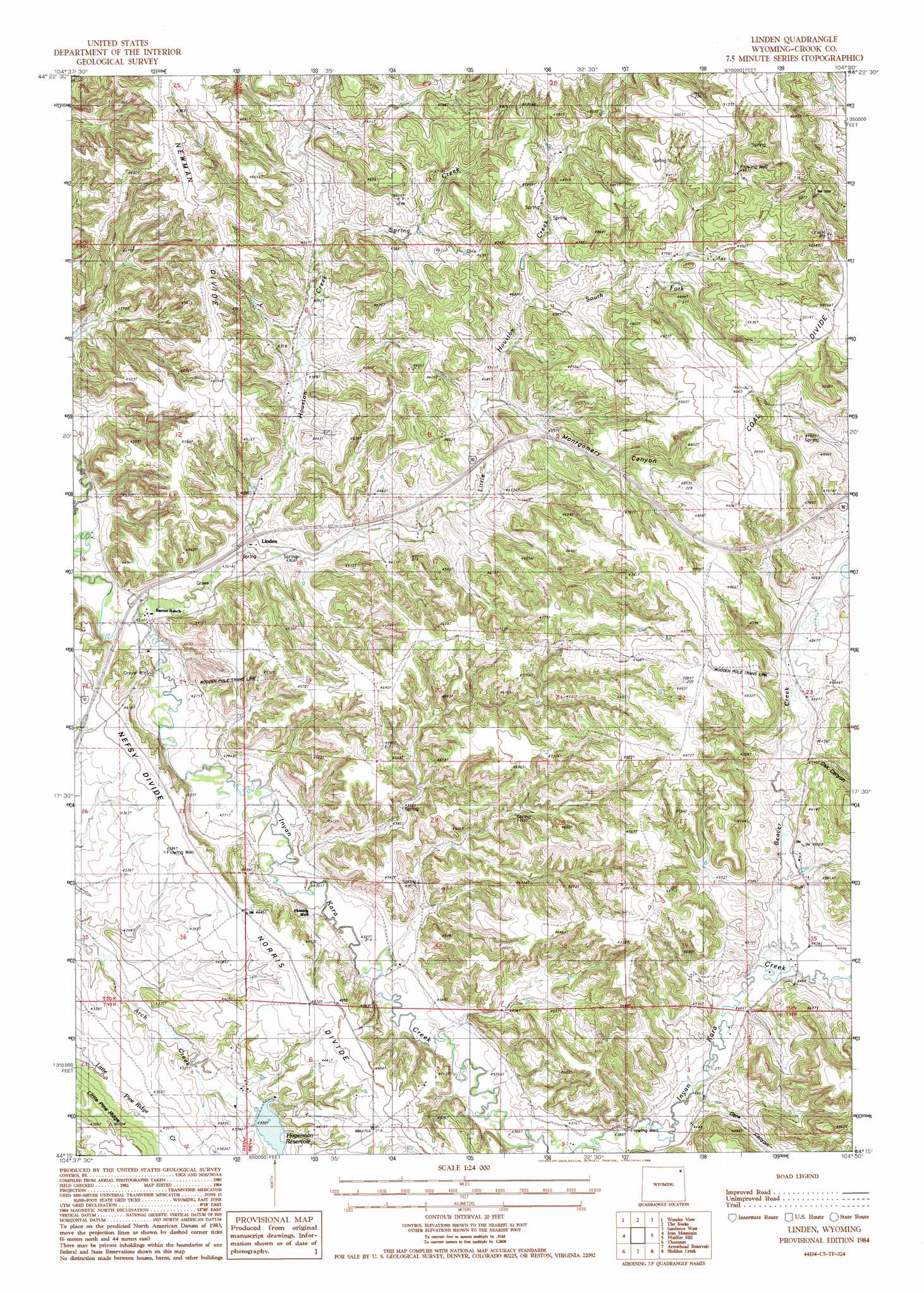
Linden Topo Map Wyoming
To zoom in, hover over the map of Linden
USGS Topo Quad 44104c5 - 1:24,000 scale
| Topo Map Name: | Linden |
| USGS Topo Quad ID: | 44104c5 |
| Print Size: | ca. 21 1/4" wide x 27" high |
| Southeast Coordinates: | 44.25° N latitude / 104.5° W longitude |
| Map Center Coordinates: | 44.3125° N latitude / 104.5625° W longitude |
| U.S. State: | WY |
| Filename: | o44104c5.jpg |
| Download Map JPG Image: | Linden topo map 1:24,000 scale |
| Map Type: | Topographic |
| Topo Series: | 7.5´ |
| Map Scale: | 1:24,000 |
| Source of Map Images: | United States Geological Survey (USGS) |
| Alternate Map Versions: |
Linden WY 1984, updated 1985 Download PDF Buy paper map Linden WY 2012 Download PDF Buy paper map Linden WY 2015 Download PDF Buy paper map |
1:24,000 Topo Quads surrounding Linden
Missouri Buttes |
Devils Tower |
Sherrard Hill |
Black Hills |
Sugarloaf Mountain |
Carlile |
Wonder View |
The Rocks |
Sundance West |
Sundance East |
Grasshopper Butte |
Iron Mountain |
Linden |
Pfeiffer Hill |
Duling Hill |
Freda Creek |
Thornton |
Arrowhead Reservoir |
Sheldon Creek |
Inyan Kara Mountain |
Soda Butte |
Upton West |
Upton East |
Clay Spur |
Skull Creek |
> Back to 44104a1 at 1:100,000 scale
> Back to 44104a1 at 1:250,000 scale
> Back to U.S. Topo Maps home
Linden topo map: Gazetteer
Linden: Dams
Enlargement Little Pine Ridge Dam elevation 1319m 4327′Fred Dam elevation 1382m 4534′
Hagerman Dam elevation 1331m 4366′
Richard Dam elevation 1388m 4553′
Steven Dam elevation 1410m 4625′
Linden: Mines
Gose Ranch Property Mine elevation 1322m 4337′Pyles and Olson Mine elevation 1474m 4835′
Linden: Populated Places
Linden elevation 1312m 4304′Linden: Reservoirs
Enlargement Little Pine Ridge Reservoir elevation 1319m 4327′Fred Reservoir elevation 1382m 4534′
Hagerman Reservoir elevation 1320m 4330′
Richard Reservoir elevation 1388m 4553′
Steven Reservoir elevation 1410m 4625′
Linden: Ridges
Coal Divide elevation 1525m 5003′Little Pine Ridge elevation 1335m 4379′
Newman Divide elevation 1431m 4694′
Norris Divide elevation 1358m 4455′
Linden: Streams
Beaver Creek elevation 1358m 4455′Fescue Creek elevation 1384m 4540′
Houston Creek elevation 1292m 4238′
Little Houston Creek elevation 1306m 4284′
Oak Canyon elevation 1379m 4524′
South Fork Little Houston Creek elevation 1391m 4563′
Spring Creek elevation 1348m 4422′
Linden: Valleys
Dark Canyon elevation 1349m 4425′Montgomery Canyon elevation 1375m 4511′
Linden digital topo map on disk
Buy this Linden topo map showing relief, roads, GPS coordinates and other geographical features, as a high-resolution digital map file on DVD:
Eastern Wyoming & Western South Dakota
Buy digital topo maps: Eastern Wyoming & Western South Dakota