Cottonwood Creek Topo Map Idaho
To zoom in, hover over the map of Cottonwood Creek
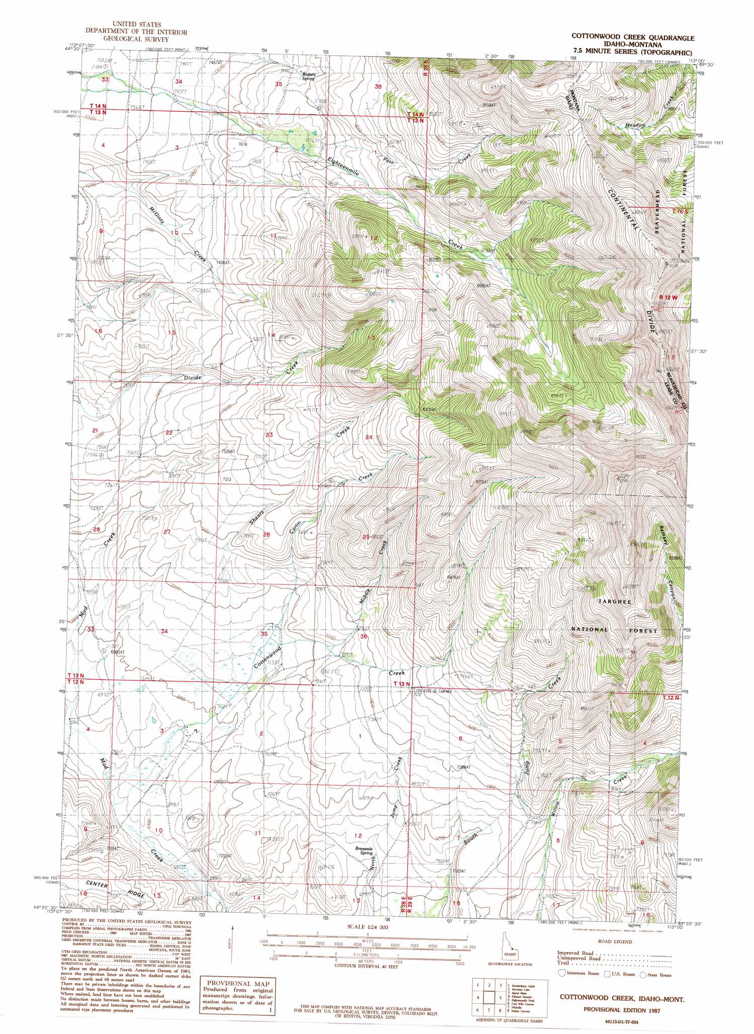
USGS Topo Quad 44113d1 - 1:24,000 scale
| Topo Map Name: | Cottonwood Creek |
| USGS Topo Quad ID: | 44113d1 |
| Print Size: | ca. 21 1/4" wide x 27" high |
| Southeast Coordinates: | 44.375° N latitude / 113° W longitude |
| Map Center Coordinates: | 44.4375° N latitude / 113.0625° W longitude |
| U.S. States: | ID, MT |
| Filename: | o44113d1.jpg |
| Download Map JPG Image: | Cottonwood Creek topo map 1:24,000 scale |
| Map Type: | Topographic |
| Topo Series: | 7.5´ |
| Map Scale: | 1:24,000 |
| Source of Map Images: | United States Geological Survey (USGS) |
| Alternate Map Versions: |
Cottonwood Creek ID 1987, updated 1987 Download PDF Buy paper map Cottonwood Creek ID 1997, updated 2002 Download PDF Buy paper map Cottonwood Creek ID 2011 Download PDF Buy paper map Cottonwood Creek ID 2013 Download PDF Buy paper map |
| FStopo: | US Forest Service topo Cottonwood Creek is available: Download FStopo PDF Download FStopo TIF |
1:24,000 Topo Quads surrounding Cottonwood Creek
Leadore |
Reservoir Creek |
Tepee Mountain |
Graphite Mountain |
Dixon Mountain |
Purcell Spring |
Powderhorn Gulch |
Morrison Lake |
Island Butte |
Caboose Canyon |
Gilmore |
Gilmore Summit |
Cottonwood Creek |
Eighteenmile Peak |
Deadman Lake |
Big Windy Peak |
Coal Kiln Canyon |
Nicholia |
Italian Canyon |
Scott Peak |
Mulkey Bar |
Bell Mountain |
Diamond Peak |
Blue Dome |
Copper Mountain |
> Back to 44113a1 at 1:100,000 scale
> Back to 44112a1 at 1:250,000 scale
> Back to U.S. Topo Maps home
Cottonwood Creek topo map: Gazetteer
Cottonwood Creek: Springs
Breazeale Spring elevation 2149m 7050′Walters Spring elevation 2340m 7677′
Cottonwood Creek: Streams
Carlin Creek elevation 2168m 7112′Cottonwood Creek elevation 2089m 6853′
Middle Creek elevation 2210m 7250′
Pass Creek elevation 2328m 7637′
Shears Creek elevation 2133m 6998′
Cottonwood Creek digital topo map on disk
Buy this Cottonwood Creek topo map showing relief, roads, GPS coordinates and other geographical features, as a high-resolution digital map file on DVD: