Casto Topo Map Idaho
To zoom in, hover over the map of Casto
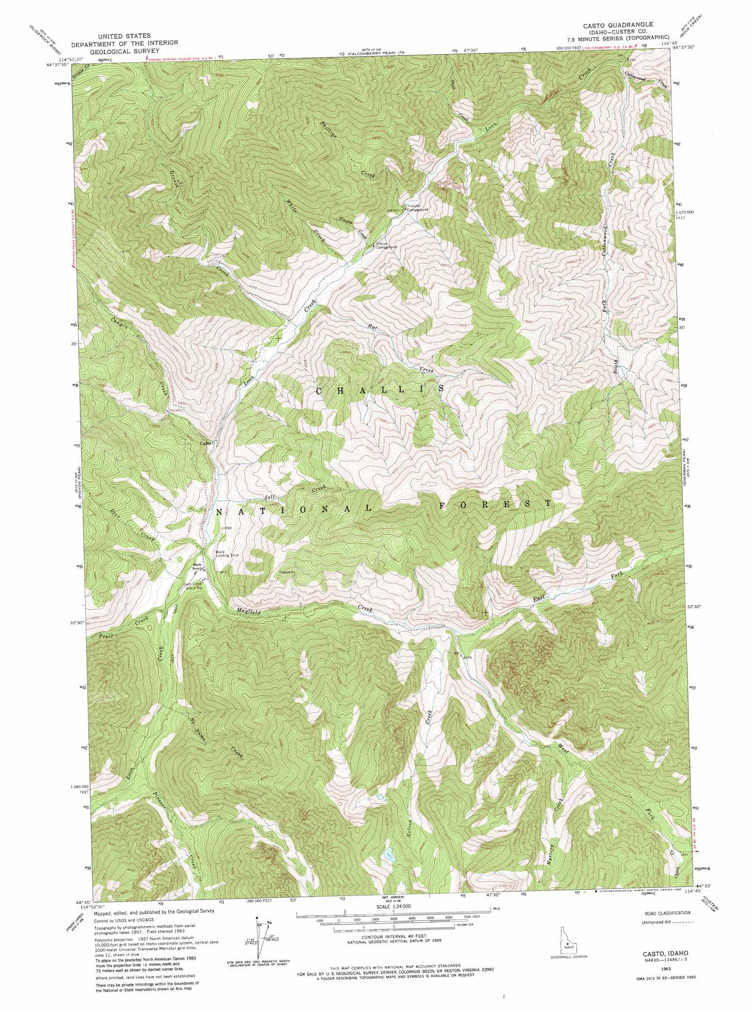
USGS Topo Quad 44114e7 - 1:24,000 scale
| Topo Map Name: | Casto |
| USGS Topo Quad ID: | 44114e7 |
| Print Size: | ca. 21 1/4" wide x 27" high |
| Southeast Coordinates: | 44.5° N latitude / 114.75° W longitude |
| Map Center Coordinates: | 44.5625° N latitude / 114.8125° W longitude |
| U.S. State: | ID |
| Filename: | o44114e7.jpg |
| Download Map JPG Image: | Casto topo map 1:24,000 scale |
| Map Type: | Topographic |
| Topo Series: | 7.5´ |
| Map Scale: | 1:24,000 |
| Source of Map Images: | United States Geological Survey (USGS) |
| Alternate Map Versions: |
Casto ID 1963, updated 1964 Download PDF Buy paper map Casto ID 1963, updated 1982 Download PDF Buy paper map Casto ID 1963, updated 1982 Download PDF Buy paper map Casto ID 2011 Download PDF Buy paper map Casto ID 2013 Download PDF Buy paper map |
| FStopo: | US Forest Service topo Casto is available: Download FStopo PDF Download FStopo TIF |
1:24,000 Topo Quads surrounding Casto
Pungo Mountain |
Norton Ridge |
Ramey Hill |
Sleeping Deer Mountain |
Meyers Cove |
Little Soldier Mountain |
Sliderock Ridge |
Falconberry Peak |
Rock Creek |
Sheldon Peak |
Greyhound Mountain |
Pinyon Peak |
Casto |
Sherman Peak |
Challis Creek Lakes |
Langer Peak |
Knapp Lakes |
Mount Jordan |
Custer |
Elevenmile Creek |
Elk Meadow |
Basin Butte |
East Basin Creek |
Sunbeam |
Thompson Creek |
> Back to 44114e1 at 1:100,000 scale
> Back to 44114a1 at 1:250,000 scale
> Back to U.S. Topo Maps home
Casto topo map: Gazetteer
Casto: Airports
Loon Creek Landing Strip elevation 1656m 5433′Upper Loon Creek-US Forest Service Airport elevation 1764m 5787′
Casto: Populated Places
Casto elevation 1721m 5646′Casto: Streams
Canyon Creek elevation 1706m 5597′China Creek elevation 2108m 6916′
Cottonwood Creek elevation 1570m 5150′
Deer Creek elevation 1755m 5757′
East Fork Mayfield Creek elevation 1919m 6295′
Grouse Creek elevation 1672m 5485′
Mayfield Creek elevation 1742m 5715′
Mystery Creek elevation 2023m 6637′
Nelson Creek elevation 1897m 6223′
No Name Creek elevation 1805m 5921′
Phillips Creek elevation 1635m 5364′
Pioneer Creek elevation 1825m 5987′
Rat Creek elevation 1660m 5446′
Salt Creek elevation 1724m 5656′
Shell Creek elevation 1617m 5305′
South Fork Cottonwood Creek elevation 1584m 5196′
Tincup Creek elevation 1645m 5396′
Trail Creek elevation 1766m 5793′
West Fork Mayfield Creek elevation 1908m 6259′
White Creek elevation 1652m 5419′
Casto digital topo map on disk
Buy this Casto topo map showing relief, roads, GPS coordinates and other geographical features, as a high-resolution digital map file on DVD: