Greyhound Mountain Topo Map Idaho
To zoom in, hover over the map of Greyhound Mountain
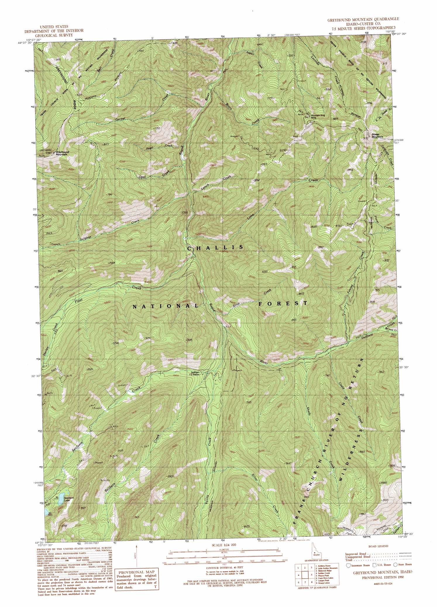
USGS Topo Quad 44115e1 - 1:24,000 scale
| Topo Map Name: | Greyhound Mountain |
| USGS Topo Quad ID: | 44115e1 |
| Print Size: | ca. 21 1/4" wide x 27" high |
| Southeast Coordinates: | 44.5° N latitude / 115° W longitude |
| Map Center Coordinates: | 44.5625° N latitude / 115.0625° W longitude |
| U.S. State: | ID |
| Filename: | o44115e1.jpg |
| Download Map JPG Image: | Greyhound Mountain topo map 1:24,000 scale |
| Map Type: | Topographic |
| Topo Series: | 7.5´ |
| Map Scale: | 1:24,000 |
| Source of Map Images: | United States Geological Survey (USGS) |
| Alternate Map Versions: |
Greyhound Mountain ID 1990, updated 1991 Download PDF Buy paper map Greyhound Mountain ID 2011 Download PDF Buy paper map Greyhound Mountain ID 2013 Download PDF Buy paper map |
| FStopo: | US Forest Service topo Greyhound Mountain is available: Download FStopo PDF Download FStopo TIF |
1:24,000 Topo Quads surrounding Greyhound Mountain
Big Chief Creek |
Big Baldy |
Pungo Mountain |
Norton Ridge |
Ramey Hill |
Chinook Mountain |
Artillery Dome |
Little Soldier Mountain |
Sliderock Ridge |
Falconberry Peak |
Big Soldier Mountain |
Soldier Creek |
Greyhound Mountain |
Pinyon Peak |
Casto |
Blue Bunch Mountain |
Cape Horn Lakes |
Langer Peak |
Knapp Lakes |
Mount Jordan |
Bull Trout Point |
Banner Summit |
Elk Meadow |
Basin Butte |
East Basin Creek |
> Back to 44115e1 at 1:100,000 scale
> Back to 44114a1 at 1:250,000 scale
> Back to U.S. Topo Maps home
Greyhound Mountain topo map: Gazetteer
Greyhound Mountain: Lakes
Seafoam Lake elevation 2371m 7778′Greyhound Mountain: Mines
Mountain King Mine elevation 2551m 8369′Greyhound Mountain: Streams
Aspen Creek elevation 1699m 5574′Baldwin Creek elevation 1886m 6187′
Bernard Creek elevation 1949m 6394′
Bruin Creek elevation 1717m 5633′
Casto Creek elevation 1912m 6272′
Drop Creek elevation 1829m 6000′
Duffield Creek elevation 1920m 6299′
Float Creek elevation 1801m 5908′
Fontez Creek elevation 1924m 6312′
Garnet Creek elevation 1730m 5675′
Harlan Creek elevation 2002m 6568′
Lime Creek elevation 1797m 5895′
Lunch Creek elevation 1766m 5793′
Opal Creek elevation 1768m 5800′
Pearl Creek elevation 1754m 5754′
Seafoam Creek elevation 1834m 6017′
Shady Creek elevation 1905m 6250′
Silver Creek elevation 1994m 6541′
Sulphur Creek elevation 1771m 5810′
Vanity Creek elevation 1873m 6145′
Greyhound Mountain: Summits
Greyhound Mountain elevation 2716m 8910′Greyhound Mountain digital topo map on disk
Buy this Greyhound Mountain topo map showing relief, roads, GPS coordinates and other geographical features, as a high-resolution digital map file on DVD: