Bear Creek Point Topo Map Idaho
To zoom in, hover over the map of Bear Creek Point
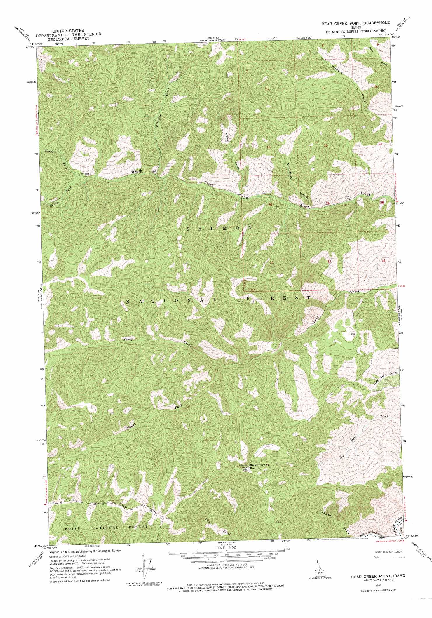
USGS Topo Quad 44114h7 - 1:24,000 scale
| Topo Map Name: | Bear Creek Point |
| USGS Topo Quad ID: | 44114h7 |
| Print Size: | ca. 21 1/4" wide x 27" high |
| Southeast Coordinates: | 44.875° N latitude / 114.75° W longitude |
| Map Center Coordinates: | 44.9375° N latitude / 114.8125° W longitude |
| U.S. State: | ID |
| Filename: | o44114h7.jpg |
| Download Map JPG Image: | Bear Creek Point topo map 1:24,000 scale |
| Map Type: | Topographic |
| Topo Series: | 7.5´ |
| Map Scale: | 1:24,000 |
| Source of Map Images: | United States Geological Survey (USGS) |
| Alternate Map Versions: |
Bear Creek Point ID 1962, updated 1963 Download PDF Buy paper map Bear Creek Point ID 1962, updated 1975 Download PDF Buy paper map Bear Creek Point ID 2011 Download PDF Buy paper map Bear Creek Point ID 2013 Download PDF Buy paper map |
| FStopo: | US Forest Service topo Bear Creek Point is available: Download FStopo PDF Download FStopo TIF |
1:24,000 Topo Quads surrounding Bear Creek Point
Acorn Butte |
Vinegar Hill |
Papoose Peak |
Aggipah Mountain |
Mount Mcguire |
Monument |
Mormon Mountain |
Dave Lewis Peak |
Puddin Mountain |
Hoodoo Meadows |
Safety Creek |
Shellrock Peak |
Bear Creek Point |
Aparejo Point |
Yellowjacket |
Pungo Mountain |
Norton Ridge |
Ramey Hill |
Sleeping Deer Mountain |
Meyers Cove |
Little Soldier Mountain |
Sliderock Ridge |
Falconberry Peak |
Rock Creek |
Sheldon Peak |
> Back to 44114e1 at 1:100,000 scale
> Back to 44114a1 at 1:250,000 scale
> Back to U.S. Topo Maps home
Bear Creek Point topo map: Gazetteer
Bear Creek Point: Flats
Cow Basin elevation 1645m 5396′Bear Creek Point: Streams
Horn Creek elevation 1425m 4675′North Fork Brush Creek elevation 1691m 5547′
Paradise Creek elevation 1556m 5104′
South Fork Brush Creek elevation 1691m 5547′
South Fork Sheep Creek elevation 1548m 5078′
Bear Creek Point: Summits
Bear Creek Point elevation 2623m 8605′Bear Creek Point: Valleys
Countess Gulch elevation 1357m 4452′Bear Creek Point digital topo map on disk
Buy this Bear Creek Point topo map showing relief, roads, GPS coordinates and other geographical features, as a high-resolution digital map file on DVD: