Puddin Mountain Topo Map Idaho
To zoom in, hover over the map of Puddin Mountain
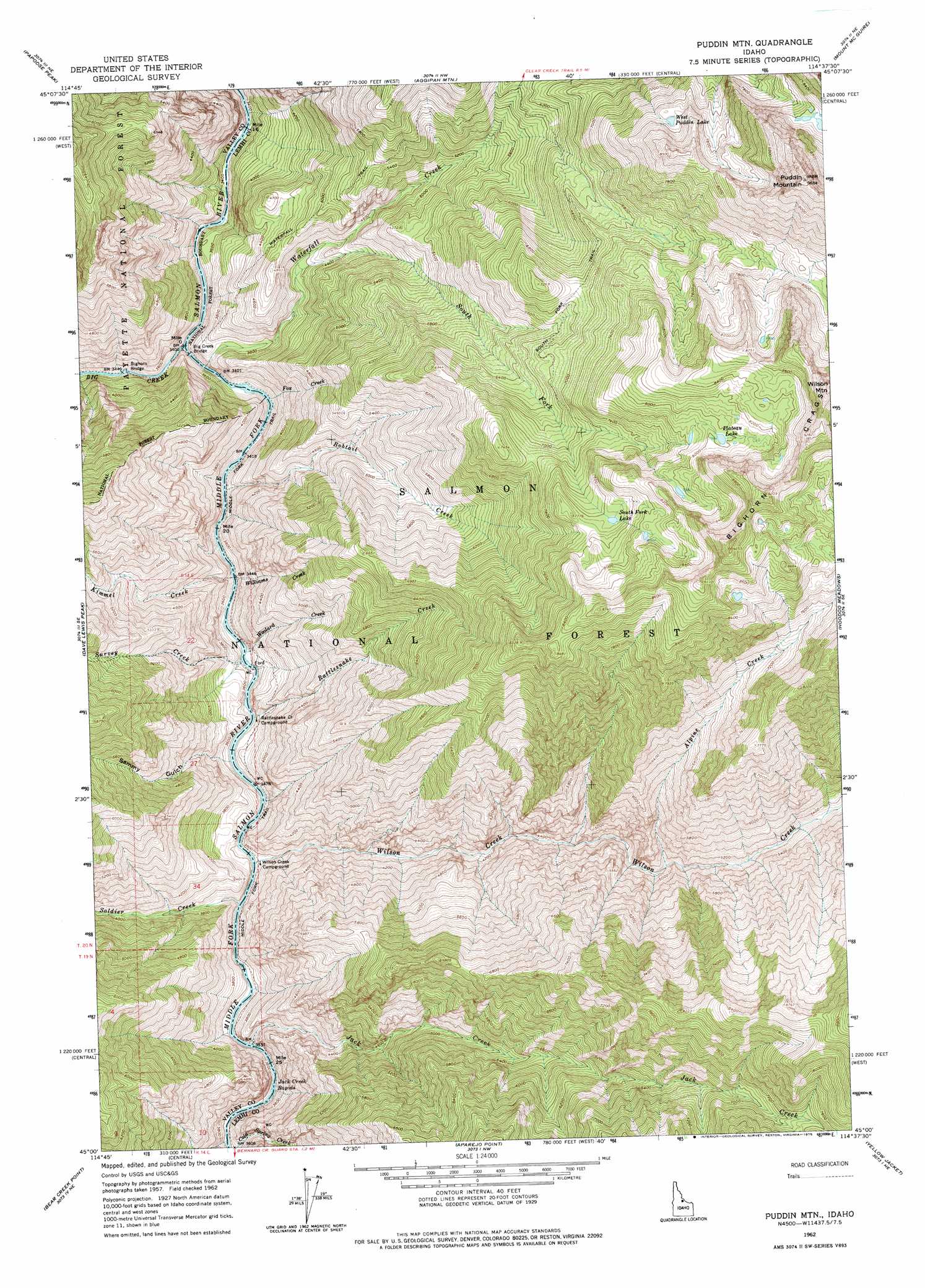
USGS Topo Quad 45114a6 - 1:24,000 scale
| Topo Map Name: | Puddin Mountain |
| USGS Topo Quad ID: | 45114a6 |
| Print Size: | ca. 21 1/4" wide x 27" high |
| Southeast Coordinates: | 45° N latitude / 114.625° W longitude |
| Map Center Coordinates: | 45.0625° N latitude / 114.6875° W longitude |
| U.S. State: | ID |
| Filename: | o45114a6.jpg |
| Download Map JPG Image: | Puddin Mountain topo map 1:24,000 scale |
| Map Type: | Topographic |
| Topo Series: | 7.5´ |
| Map Scale: | 1:24,000 |
| Source of Map Images: | United States Geological Survey (USGS) |
| Alternate Map Versions: |
Puddin Mtn ID 1962, updated 1964 Download PDF Buy paper map Puddin Mtn ID 1962, updated 1975 Download PDF Buy paper map Puddin Mountain ID 2011 Download PDF Buy paper map Puddin Mountain ID 2013 Download PDF Buy paper map |
| FStopo: | US Forest Service topo Puddin Mountain is available: Download FStopo PDF Download FStopo TIF |
1:24,000 Topo Quads surrounding Puddin Mountain
Cold Meadows |
Cottonwood Butte |
Butts Creek Point |
Long Tom Mountain |
Bighorn Crags |
Vinegar Hill |
Papoose Peak |
Aggipah Mountain |
Mount Mcguire |
Gant Ridge |
Mormon Mountain |
Dave Lewis Peak |
Puddin Mountain |
Hoodoo Meadows |
Blackbird Mountain |
Shellrock Peak |
Bear Creek Point |
Aparejo Point |
Yellowjacket |
Duck Creek Point |
Norton Ridge |
Ramey Hill |
Sleeping Deer Mountain |
Meyers Cove |
Meyers Cove Point |
> Back to 45114a1 at 1:100,000 scale
> Back to 45114a1 at 1:250,000 scale
> Back to U.S. Topo Maps home
Puddin Mountain topo map: Gazetteer
Puddin Mountain: Bridges
Big Creek Bridge elevation 1321m 4333′Bighorn Bridge elevation 1067m 3500′
Waterfall Creek Bridge elevation 1069m 3507′
Puddin Mountain: Lakes
Plateau Lake elevation 2544m 8346′South Fork Lake elevation 2717m 8914′
West Puddin Lake elevation 2669m 8756′
Puddin Mountain: Parks
Idaho Primitive Area elevation 2343m 7687′Puddin Mountain: Rapids
Jack Creek Rapids elevation 1722m 5649′Puddin Mountain: Streams
Alpine Creek elevation 1493m 4898′Big Creek elevation 1243m 4078′
Bobtail Creek elevation 1664m 5459′
Fox Creek elevation 1967m 6453′
Jack Creek elevation 1435m 4708′
Kimmel Creek elevation 1828m 5997′
Rattlesnake Creek elevation 1718m 5636′
Soldier Creek elevation 1755m 5757′
South Fork Waterfall Creek elevation 2058m 6751′
Survey Creek elevation 1517m 4977′
Waterfall Creek elevation 1033m 3389′
Williams Creek elevation 1849m 6066′
Wilson Creek elevation 1070m 3510′
Woolard Creek elevation 1570m 5150′
Puddin Mountain: Summits
Wilson Mountain elevation 2914m 9560′Puddin Mountain: Trails
South Fork Trail elevation 2216m 7270′Puddin Mountain: Valleys
Sammy Gulch elevation 1443m 4734′Puddin Mountain digital topo map on disk
Buy this Puddin Mountain topo map showing relief, roads, GPS coordinates and other geographical features, as a high-resolution digital map file on DVD: