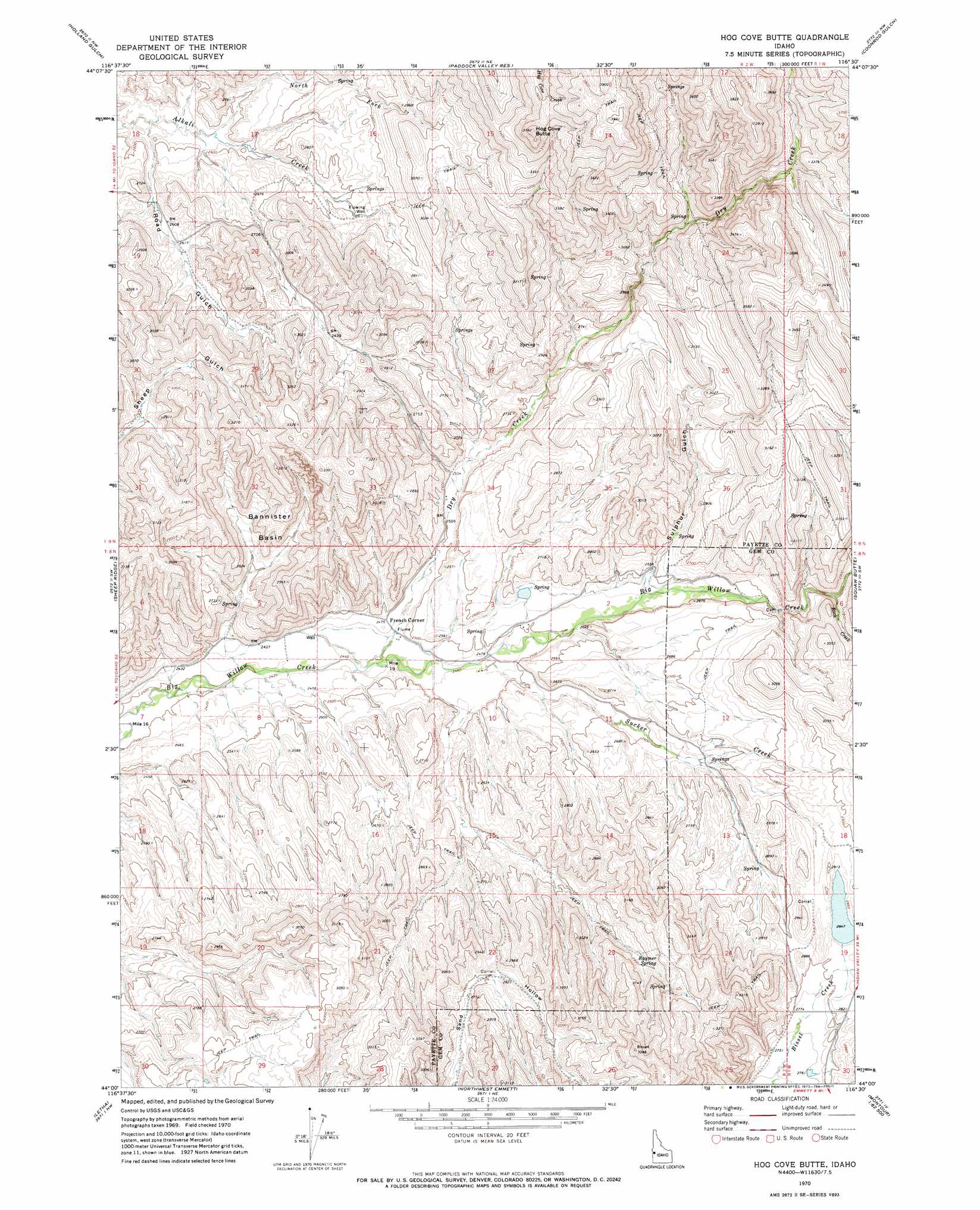
Hog Cove Butte Topo Map Idaho
To zoom in, hover over the map of Hog Cove Butte
USGS Topo Quad 44116a5 - 1:24,000 scale
| Topo Map Name: | Hog Cove Butte |
| USGS Topo Quad ID: | 44116a5 |
| Print Size: | ca. 21 1/4" wide x 27" high |
| Southeast Coordinates: | 44° N latitude / 116.5° W longitude |
| Map Center Coordinates: | 44.0625° N latitude / 116.5625° W longitude |
| U.S. State: | ID |
| Filename: | o44116a5.jpg |
| Download Map JPG Image: | Hog Cove Butte topo map 1:24,000 scale |
| Map Type: | Topographic |
| Topo Series: | 7.5´ |
| Map Scale: | 1:24,000 |
| Source of Map Images: | United States Geological Survey (USGS) |
| Alternate Map Versions: |
Hog Cove Butte ID 1970, updated 1973 Download PDF Buy paper map Hog Cove Butte ID 2010 Download PDF Buy paper map Hog Cove Butte ID 2013 Download PDF Buy paper map |
1:24,000 Topo Quads surrounding Hog Cove Butte
Mann Creek Se |
Nutmeg Flat |
Crane Creek Reservoir |
Riley Butte |
Dodson Pass |
Weiser Cove |
Holland Gulch |
Paddock Valley Reservoir |
Coonrod Gulch |
Ola |
Birding Island |
Sheep Ridge |
Hog Cove Butte |
Squaw Butte |
Webb Creek |
New Plymouth |
Letha |
Northwest Emmett |
Northeast Emmett |
Montour |
Parma Se |
Sand Hollow |
Southwest Emmett |
Southeast Emmett |
Pearl |
> Back to 44116a1 at 1:100,000 scale
> Back to 44116a1 at 1:250,000 scale
> Back to U.S. Topo Maps home
Hog Cove Butte topo map: Gazetteer
Hog Cove Butte: Basins
Bannister Basin elevation 873m 2864′Hog Cove Butte: Dams
Bettis Dam elevation 787m 2582′Bettis Number Three Dam elevation 777m 2549′
Bettis Number Two Dam elevation 778m 2552′
Little Dam elevation 869m 2851′
Hog Cove Butte: Populated Places
French Corner elevation 755m 2477′Hog Cove Butte: Reservoirs
Bettis Reservoir elevation 787m 2582′Hog Cove Butte: Springs
Raymer Spring elevation 919m 3015′Hog Cove Butte: Streams
Dry Creek elevation 746m 2447′North Fork Alkali Creek elevation 785m 2575′
Rock Creek elevation 816m 2677′
Sucker Creek elevation 751m 2463′
Hog Cove Butte: Summits
Hog Cove Butte elevation 1142m 3746′Hog Cove Butte: Valleys
Road Gulch elevation 774m 2539′Sulphur Gulch elevation 775m 2542′
Hog Cove Butte digital topo map on disk
Buy this Hog Cove Butte topo map showing relief, roads, GPS coordinates and other geographical features, as a high-resolution digital map file on DVD: