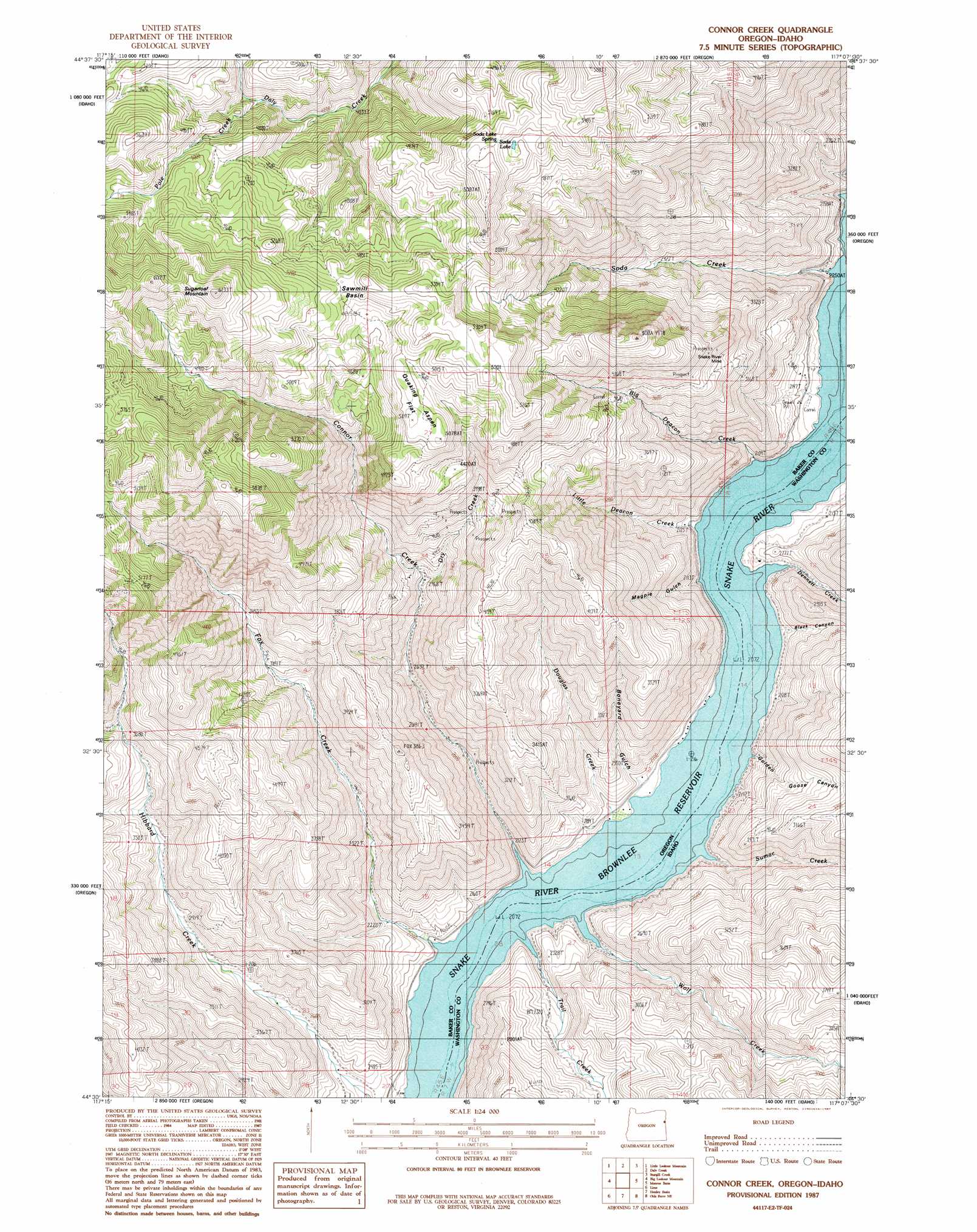
Connor Creek Topo Map Oregon
To zoom in, hover over the map of Connor Creek
USGS Topo Quad 44117e2 - 1:24,000 scale
| Topo Map Name: | Connor Creek |
| USGS Topo Quad ID: | 44117e2 |
| Print Size: | ca. 21 1/4" wide x 27" high |
| Southeast Coordinates: | 44.5° N latitude / 117.125° W longitude |
| Map Center Coordinates: | 44.5625° N latitude / 117.1875° W longitude |
| U.S. States: | OR, ID |
| Filename: | o44117e2.jpg |
| Download Map JPG Image: | Connor Creek topo map 1:24,000 scale |
| Map Type: | Topographic |
| Topo Series: | 7.5´ |
| Map Scale: | 1:24,000 |
| Source of Map Images: | United States Geological Survey (USGS) |
| Alternate Map Versions: |
Connor Creek OR 1987, updated 1987 Download PDF Buy paper map Connor Creek OR 2011 Download PDF Buy paper map Connor Creek OR 2014 Download PDF Buy paper map |
1:24,000 Topo Quads surrounding Connor Creek
Glasgow Butte |
Sparta |
Richland |
Posy Valley |
Brownlee Dam |
Lawrence Creek |
Little Lookout Mountain |
Daly Creek |
Sturgill Creek |
Neil Gulch |
Durkee |
Big Lookout Mountain |
Connor Creek |
Monroe Butte |
Sturgill Peak |
Rye Valley |
Lime |
Henley Basin |
Olds Ferry Ne |
Mann Creek Nw |
Birch Creek Meadow |
Huntington |
Olds Ferry |
Porters Flat |
Weiser North |
> Back to 44117e1 at 1:100,000 scale
> Back to 44116a1 at 1:250,000 scale
> Back to U.S. Topo Maps home
Connor Creek topo map: Gazetteer
Connor Creek: Basins
Sawmill Basin elevation 1521m 4990′Connor Creek: Flats
Quaking Aspen Flat elevation 1479m 4852′Connor Creek: Gaps
Dean Pass elevation 1286m 4219′Connor Creek: Mines
Connor Creek Mine elevation 1266m 4153′Snake River Mine elevation 1131m 3710′
Connor Creek: Populated Places
Conner Creek (historical) elevation 1299m 4261′Connor Creek: Post Offices
Connor Creek Post Office (historical) elevation 1299m 4261′Home Post Office (historical) elevation 629m 2063′
Connor Creek: Springs
Soda Lake Spring elevation 1615m 5298′Soda Spring elevation 669m 2194′
Tucker Spring elevation 1124m 3687′
Connor Creek: Streams
Big Deacon Creek elevation 690m 2263′Connor Creek elevation 629m 2063′
Dennett Creek elevation 629m 2063′
Douglas Creek elevation 631m 2070′
Dry Creek elevation 898m 2946′
Fox Creek elevation 651m 2135′
Little Deacon Creek elevation 665m 2181′
Pole Creek elevation 1338m 4389′
Soda Creek elevation 629m 2063′
Sumac Creek elevation 629m 2063′
Trail Creek elevation 629m 2063′
Wolf Creek elevation 629m 2063′
Connor Creek: Summits
Sugarloaf Mountain elevation 1845m 6053′Connor Creek: Valleys
Black Canyon elevation 629m 2063′Boneyard Gulch elevation 637m 2089′
Golden Goose Canyon elevation 629m 2063′
Magpie Gulch elevation 629m 2063′
Connor Creek digital topo map on disk
Buy this Connor Creek topo map showing relief, roads, GPS coordinates and other geographical features, as a high-resolution digital map file on DVD: