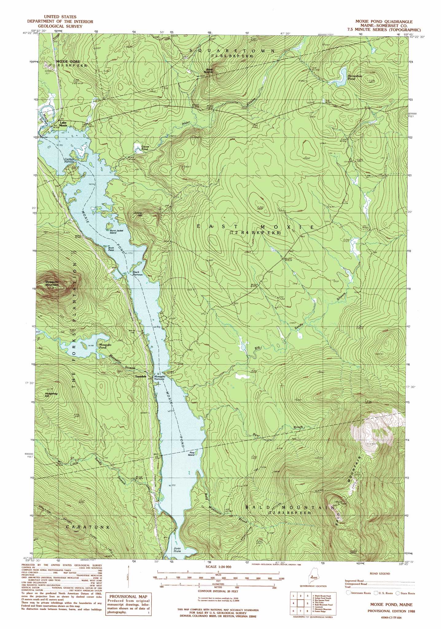
Moxie Pond Topo Map Maine
To zoom in, hover over the map of Moxie Pond
USGS Topo Quad 45069c7 - 1:24,000 scale
| Topo Map Name: | Moxie Pond |
| USGS Topo Quad ID: | 45069c7 |
| Print Size: | ca. 21 1/4" wide x 27" high |
| Southeast Coordinates: | 45.25° N latitude / 69.75° W longitude |
| Map Center Coordinates: | 45.3125° N latitude / 69.8125° W longitude |
| U.S. State: | ME |
| Filename: | o45069c7.jpg |
| Download Map JPG Image: | Moxie Pond topo map 1:24,000 scale |
| Map Type: | Topographic |
| Topo Series: | 7.5´ |
| Map Scale: | 1:24,000 |
| Source of Map Images: | United States Geological Survey (USGS) |
| Alternate Map Versions: |
Moxie Pond ME 1977, updated 1981 Download PDF Buy paper map Moxie Pond ME 1988, updated 1988 Download PDF Buy paper map Moxie Pond ME 2011 Download PDF Buy paper map Moxie Pond ME 2014 Download PDF Buy paper map |
1:24,000 Topo Quads surrounding Moxie Pond
Long Pond |
Misery Knob |
Indian Pond North |
Moosehead |
Lily Bay |
Johnson Mountain |
Black Brook Pond |
Indian Pond South |
Big Squaw Pond |
Greenville |
Pierce Pond |
The Forks |
Moxie Pond |
Bald Mountain Pond |
Monson West |
East Carry Pond |
Caratunk |
Dimmick Mountain |
Foster Ridge |
Whetstone Pond |
Witham Mountain |
Bingham |
Mahoney Hill |
Kingsbury |
Wellington |
> Back to 45069a1 at 1:100,000 scale
> Back to 45068a1 at 1:250,000 scale
> Back to U.S. Topo Maps home
Moxie Pond topo map: Gazetteer
Moxie Pond: Capes
Birch Point elevation 297m 974′Moxie Pond: Channels
Black Narrows elevation 296m 971′Caribou Narrows elevation 296m 971′
Mosquito Narrows elevation 296m 971′
Moxie Pond: Dams
Moxie Pond Dam elevation 296m 971′Moxie Pond: Islands
Burnt Jacket Island elevation 302m 990′Pine Island elevation 296m 971′
Moxie Pond: Lakes
Goose Pond elevation 309m 1013′Horseshoe Pond elevation 447m 1466′
Joes Hole elevation 296m 971′
Mosquito Pond elevation 340m 1115′
Moxie Pond: Populated Places
Troutdale elevation 306m 1003′Moxie Pond: Reservoirs
Moxie Pond elevation 296m 971′Moxie Pond: Streams
Bald Mountain Brook elevation 299m 980′Bear Brook elevation 296m 971′
Big Sandy Stream elevation 296m 971′
Little Sandy Stream elevation 296m 971′
Mosquito Stream elevation 298m 977′
Moxie Pond: Summits
Bald Mountain elevation 758m 2486′Black Nubble elevation 479m 1571′
Hedgehog Hill elevation 502m 1646′
Johns Hill elevation 404m 1325′
Mosquito Mountain elevation 663m 2175′
Moxie Pond digital topo map on disk
Buy this Moxie Pond topo map showing relief, roads, GPS coordinates and other geographical features, as a high-resolution digital map file on DVD:
Maine, New Hampshire, Rhode Island & Eastern Massachusetts
Buy digital topo maps: Maine, New Hampshire, Rhode Island & Eastern Massachusetts