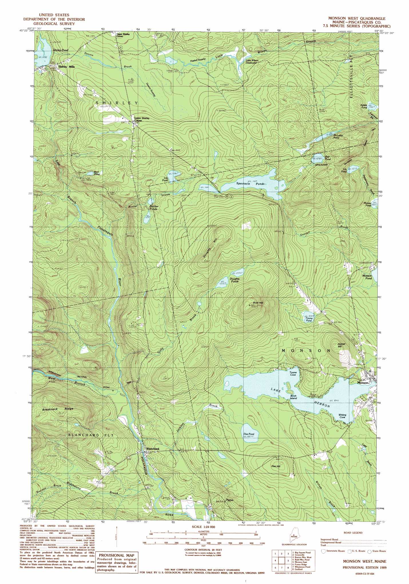
Monson West Topo Map Maine
To zoom in, hover over the map of Monson West
USGS Topo Quad 45069c5 - 1:24,000 scale
| Topo Map Name: | Monson West |
| USGS Topo Quad ID: | 45069c5 |
| Print Size: | ca. 21 1/4" wide x 27" high |
| Southeast Coordinates: | 45.25° N latitude / 69.5° W longitude |
| Map Center Coordinates: | 45.3125° N latitude / 69.5625° W longitude |
| U.S. State: | ME |
| Filename: | o45069c5.jpg |
| Download Map JPG Image: | Monson West topo map 1:24,000 scale |
| Map Type: | Topographic |
| Topo Series: | 7.5´ |
| Map Scale: | 1:24,000 |
| Source of Map Images: | United States Geological Survey (USGS) |
| Alternate Map Versions: |
Monson West ME 1977, updated 1981 Download PDF Buy paper map Monson West ME 1989, updated 1989 Download PDF Buy paper map Monson West ME 2011 Download PDF Buy paper map Monson West ME 2014 Download PDF Buy paper map |
1:24,000 Topo Quads surrounding Monson West
Indian Pond North |
Moosehead |
Lily Bay |
Number Four Mountain |
Hay Mountain |
Indian Pond South |
Big Squaw Pond |
Greenville |
Barren Mountain West |
Barren Mountain East |
Moxie Pond |
Bald Mountain Pond |
Monson West |
Monson East |
Sebec Lake West |
Dimmick Mountain |
Foster Ridge |
Whetstone Pond |
Guilford |
Sangerville |
Mahoney Hill |
Kingsbury |
Wellington |
Cambridge |
Dexter |
> Back to 45069a1 at 1:100,000 scale
> Back to 45068a1 at 1:250,000 scale
> Back to U.S. Topo Maps home
Monson West topo map: Gazetteer
Monson West: Bays
Towne Cove elevation 258m 846′Whiting Cove elevation 258m 846′
Monson West: Dams
Shirley Pond Dam elevation 315m 1033′Monson West: Islands
Birch Island elevation 262m 859′Monson West: Lakes
Bear Pond elevation 330m 1082′Bell Pond elevation 389m 1276′
Bunker Ponds elevation 336m 1102′
Doe Pond elevation 270m 885′
Doughty Ponds elevation 366m 1200′
Lily Pond elevation 343m 1125′
Lily Pond elevation 352m 1154′
Little Wilson Deadwater elevation 349m 1145′
McLellan Pond elevation 388m 1272′
Moores Pond elevation 264m 866′
Rabbit Pond elevation 351m 1151′
Spectacle Ponds elevation 355m 1164′
Towne Pond elevation 254m 833′
Monson West: Populated Places
Blanchard elevation 175m 574′Lower Shirley Corner elevation 372m 1220′
Monson elevation 262m 859′
Parrot elevation 218m 715′
Shirley Mills elevation 317m 1040′
Monson West: Reservoirs
Shirley Pond elevation 315m 1033′Monson West: Streams
Blackstone Brook elevation 168m 551′Brackett Brook elevation 214m 702′
Bunker Stream elevation 198m 649′
Dennin Brook elevation 317m 1040′
East Branch Piscataquis River elevation 179m 587′
Gully Brook elevation 185m 606′
Jackson Brook elevation 181m 593′
West Branch Piscataquis River elevation 179m 587′
Monson West: Summits
Buck Hill elevation 484m 1587′Doe Hill elevation 322m 1056′
Doughty Hill elevation 483m 1584′
Homer Hill elevation 361m 1184′
Monson West: Swamps
Dennin Swamp elevation 345m 1131′Haskell Swamp elevation 345m 1131′
Monson West digital topo map on disk
Buy this Monson West topo map showing relief, roads, GPS coordinates and other geographical features, as a high-resolution digital map file on DVD:
Maine, New Hampshire, Rhode Island & Eastern Massachusetts
Buy digital topo maps: Maine, New Hampshire, Rhode Island & Eastern Massachusetts