Cheboygan Topo Map Michigan
To zoom in, hover over the map of Cheboygan
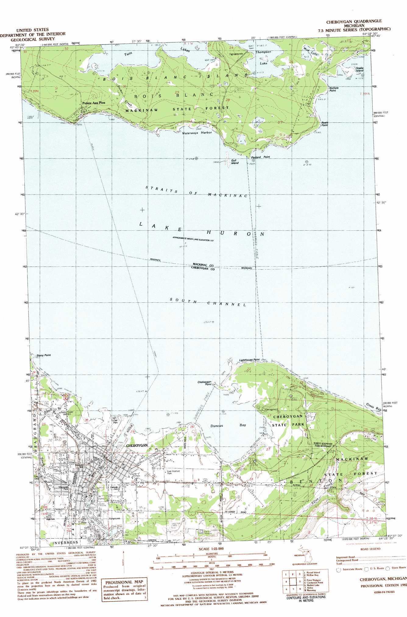
USGS Topo Quad 45084f4 - 1:25,000 scale
| Topo Map Name: | Cheboygan |
| USGS Topo Quad ID: | 45084f4 |
| Print Size: | ca. 21 1/4" wide x 27" high |
| Southeast Coordinates: | 45.625° N latitude / 84.375° W longitude |
| Map Center Coordinates: | 45.6875° N latitude / 84.4375° W longitude |
| U.S. State: | MI |
| Filename: | l45084f4.jpg |
| Download Map JPG Image: | Cheboygan topo map 1:25,000 scale |
| Map Type: | Topographic |
| Topo Series: | 7.5´ |
| Map Scale: | 1:25,000 |
| Source of Map Images: | United States Geological Survey (USGS) |
| Alternate Map Versions: |
Cheboygan MI 1982, updated 1983 Download PDF Buy paper map |
1:24,000 Topo Quads surrounding Cheboygan
Evergreen Shores |
Saint Martin Island |
Goose Island |
Cedarville |
Prentiss Bay |
Saint Ignace |
Round Island |
Mcrae Bay |
||
Freedom |
Point Nipigon |
Cheboygan |
Cordwood Point |
Ninemile Point |
Indian Village |
Mullett Lake |
Aloha |
Manning |
Grace |
Burt Lake |
Indian River |
Legrand |
Hangore Heights |
Black Lake Bluffs |
> Back to 45084e1 at 1:100,000 scale
> Back to 45084a1 at 1:250,000 scale
> Back to U.S. Topo Maps home
Cheboygan topo map: Gazetteer
Cheboygan: Bays
Duncan Bay elevation 177m 580′Grass Bay elevation 177m 580′
Waterway Harbor elevation 177m 580′
Cheboygan: Bridges
Bascule Bridge elevation 180m 590′Cheboygan: Capes
Cheboygan Point elevation 177m 580′Lighthouse Point elevation 178m 583′
Nichols Point elevation 178m 583′
Packard Point elevation 177m 580′
Rosie Point elevation 179m 587′
Stony Point elevation 177m 580′
Cheboygan: Islands
Gull Island elevation 177m 580′Snake Island elevation 178m 583′
Cheboygan: Lakes
Great Lakes elevation 177m 580′Mud Lake elevation 185m 606′
Thompson Lake elevation 185m 606′
Twin Lakes elevation 185m 606′
Cheboygan: Parks
Bois Blanc Island Historical Marker elevation 180m 590′Cheboygan State Park elevation 179m 587′
East Avenue Park elevation 180m 590′
Jacob J Post House Historical Marker elevation 180m 590′
Jail and Sheriff's Residence Historical Marker elevation 182m 597′
Kiwanis Park elevation 185m 606′
Major City Park elevation 183m 600′
Memorial Park elevation 187m 613′
Old Cheboygan County Courthouse Historical Marker elevation 183m 600′
Ottawa Art Park elevation 180m 590′
Saint Mary Church Historical Marker elevation 180m 590′
Turner Park elevation 180m 590′
Washington Park elevation 180m 590′
Cheboygan: Populated Places
Cheboygan elevation 180m 590′Pointe Aux Pins elevation 180m 590′
Town and Country Mobile Home Park elevation 194m 636′
Cheboygan: Post Offices
Cheboygan Post Office elevation 180m 590′Duncan Post Office (historical) elevation 179m 587′
Pointe Aux Pins Post Office (historical) elevation 180m 590′
Cheboygan: Streams
Cheboygan River elevation 179m 587′Elliot Creek elevation 177m 580′
Little Black River elevation 180m 590′
Sucker Creek elevation 183m 600′
Cheboygan digital topo map on disk
Buy this Cheboygan topo map showing relief, roads, GPS coordinates and other geographical features, as a high-resolution digital map file on DVD: