Clearwater Topo Map Minnesota
To zoom in, hover over the map of Clearwater
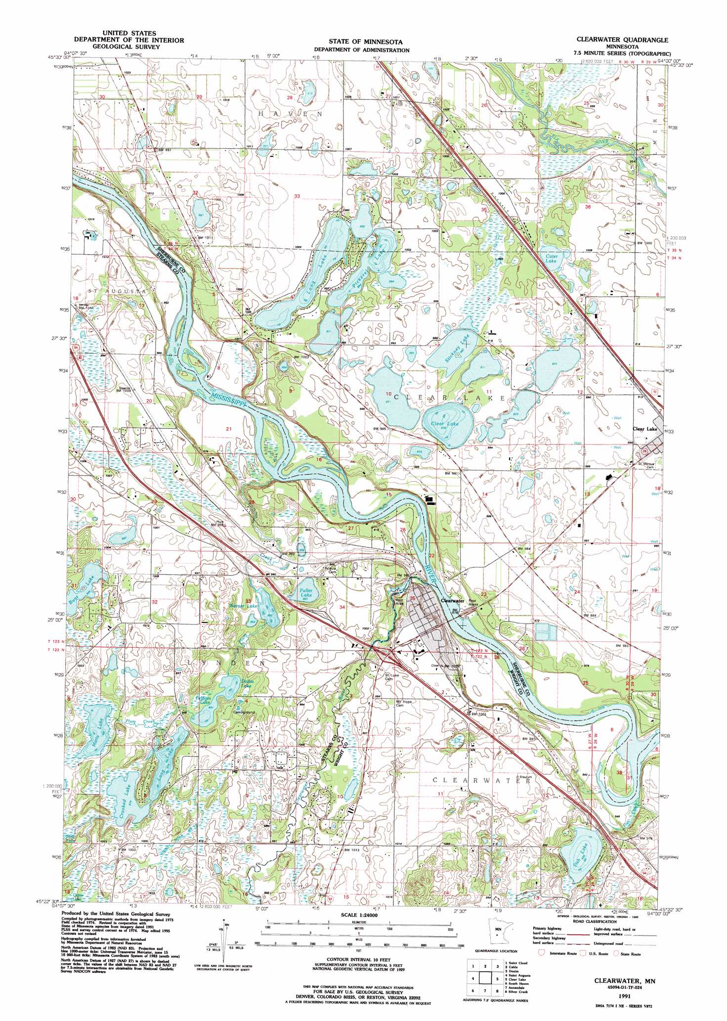
USGS Topo Quad 45094d1 - 1:24,000 scale
| Topo Map Name: | Clearwater |
| USGS Topo Quad ID: | 45094d1 |
| Print Size: | ca. 21 1/4" wide x 27" high |
| Southeast Coordinates: | 45.375° N latitude / 94° W longitude |
| Map Center Coordinates: | 45.4375° N latitude / 94.0625° W longitude |
| U.S. State: | MN |
| Filename: | o45094d1.jpg |
| Download Map JPG Image: | Clearwater topo map 1:24,000 scale |
| Map Type: | Topographic |
| Topo Series: | 7.5´ |
| Map Scale: | 1:24,000 |
| Source of Map Images: | United States Geological Survey (USGS) |
| Alternate Map Versions: |
Clearwater MN 1974, updated 1976 Download PDF Buy paper map Clearwater MN 1991, updated 1995 Download PDF Buy paper map Clearwater MN 2010 Download PDF Buy paper map Clearwater MN 2013 Download PDF Buy paper map Clearwater MN 2016 Download PDF Buy paper map |
1:24,000 Topo Quads surrounding Clearwater
Saint Stephen |
Little Rock Lake |
Mayhew |
Foley |
Ronneby |
Saint Joseph |
Saint Cloud |
Cable |
Duelm |
Santiago |
Rockville |
Saint Augusta |
Clearwater |
Clear Lake |
Becker |
Kimball |
South Haven |
Annandale |
Silver Creek |
Monticello |
Kingston |
French Lake |
Albion Center |
Buffalo West |
Buffalo East |
> Back to 45094a1 at 1:100,000 scale
> Back to 45094a1 at 1:250,000 scale
> Back to U.S. Topo Maps home
Clearwater topo map: Gazetteer
Clearwater: Airports
Haven Airport elevation 308m 1010′Clearwater: Canals
County Ditch Number Ten elevation 301m 987′Clearwater: Crossings
Interchange 178 elevation 296m 971′Clearwater: Lakes
Bunt Lake elevation 303m 994′Carter Lake elevation 300m 984′
Clear Lake elevation 297m 974′
Crooked Lake elevation 297m 974′
Dallas Lake elevation 294m 964′
Feldges Lake elevation 294m 964′
Fish Lake elevation 284m 931′
Fuller Lake elevation 290m 951′
Long Lake elevation 299m 980′
Long Lake elevation 296m 971′
Maria Lake elevation 293m 961′
Pickerel Lake elevation 300m 984′
Stickney Lake elevation 301m 987′
Warner Lake elevation 291m 954′
Clearwater: Parks
Exploring the Mississippi Headwaters Historical Marker elevation 305m 1000′Warner Lake County Park elevation 293m 961′
Clearwater: Populated Places
Clearwater elevation 294m 964′Clearwater Estates elevation 290m 951′
Clearwater: Post Offices
Clear Lake Post Office elevation 303m 994′Clearwater Post Office elevation 306m 1003′
Clearwater: Streams
Clearwater River elevation 288m 944′Fish Creek elevation 286m 938′
Plum Creek elevation 287m 941′
Clearwater digital topo map on disk
Buy this Clearwater topo map showing relief, roads, GPS coordinates and other geographical features, as a high-resolution digital map file on DVD: