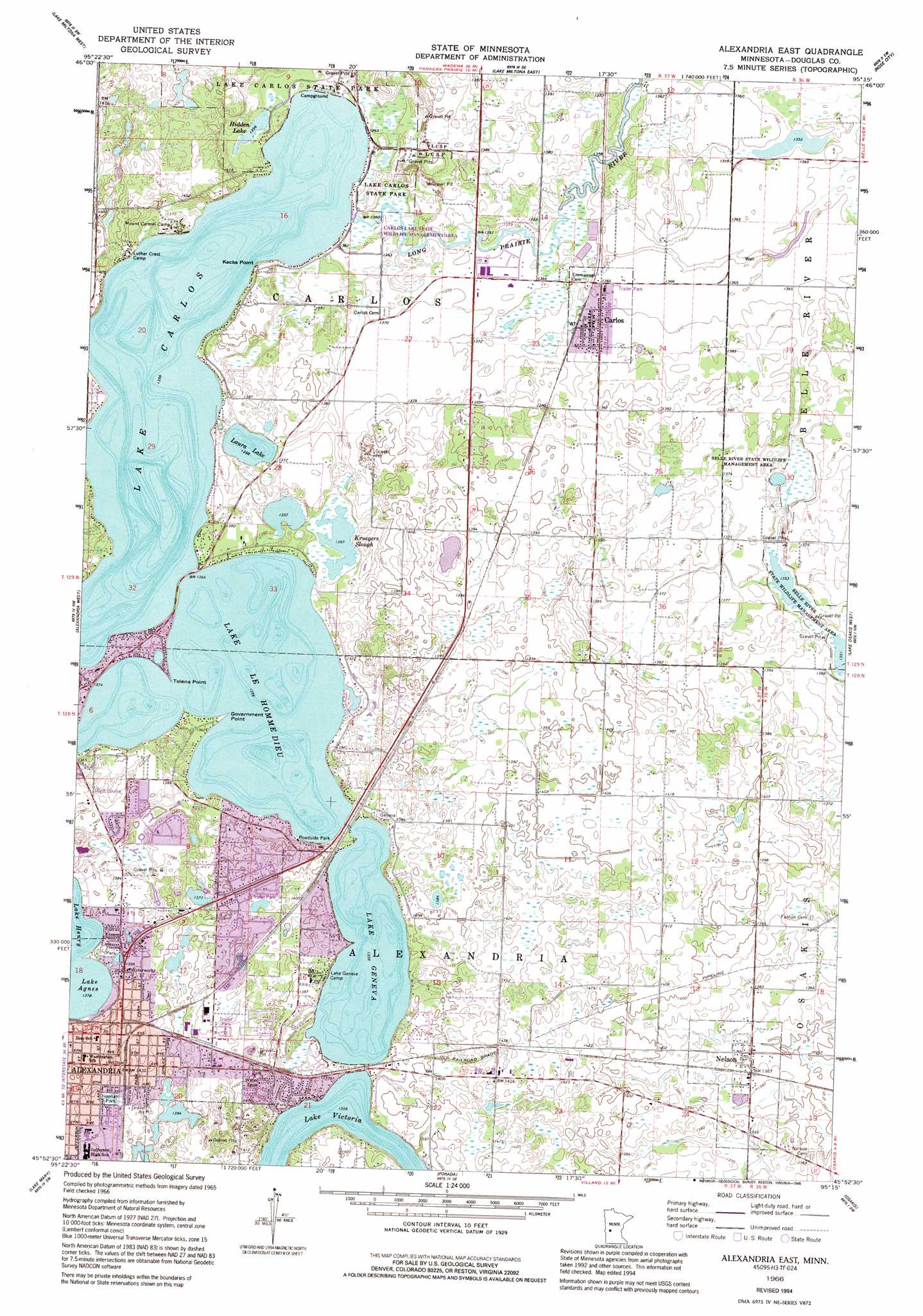
Alexandria East Topo Map Minnesota
To zoom in, hover over the map of Alexandria East
USGS Topo Quad 45095h3 - 1:24,000 scale
| Topo Map Name: | Alexandria East |
| USGS Topo Quad ID: | 45095h3 |
| Print Size: | ca. 21 1/4" wide x 27" high |
| Southeast Coordinates: | 45.875° N latitude / 95.25° W longitude |
| Map Center Coordinates: | 45.9375° N latitude / 95.3125° W longitude |
| U.S. State: | MN |
| Filename: | o45095h3.jpg |
| Download Map JPG Image: | Alexandria East topo map 1:24,000 scale |
| Map Type: | Topographic |
| Topo Series: | 7.5´ |
| Map Scale: | 1:24,000 |
| Source of Map Images: | United States Geological Survey (USGS) |
| Alternate Map Versions: |
Alexandria East MN 1966, updated 1968 Download PDF Buy paper map Alexandria East MN 1966, updated 1980 Download PDF Buy paper map Alexandria East MN 1966, updated 1995 Download PDF Buy paper map Alexandria East MN 2010 Download PDF Buy paper map Alexandria East MN 2013 Download PDF Buy paper map Alexandria East MN 2016 Download PDF Buy paper map |
1:24,000 Topo Quads surrounding Alexandria East
Inspiration Peak |
Parkers Prairie Nw |
Parkers Prairie |
Eagle Bend Nw |
Eagle Bend |
Millerville |
Lake Miltona West |
Lake Miltona East |
Rose City |
Clotho |
Brandon |
Alexandria West |
Alexandria East |
Lake Osakis West |
Lake Osakis East |
Farwell |
Lake Mary |
Forada |
Osakis |
West Union |
Lowry |
Glenwood |
Villard |
Westport |
Raymond Lake |
> Back to 45095e1 at 1:100,000 scale
> Back to 45094a1 at 1:250,000 scale
> Back to U.S. Topo Maps home
Alexandria East topo map: Gazetteer
Alexandria East: Airports
K and K Airstrip elevation 421m 1381′Alexandria East: Capes
Government Point elevation 414m 1358′Kecks Point elevation 413m 1354′
Tolena Point elevation 413m 1354′
Alexandria East: Dams
Geneva Lake Dam elevation 414m 1358′Victoria Lake Dam elevation 413m 1354′
Alexandria East: Lakes
Hidden Lake elevation 414m 1358′Kruegers Slough elevation 414m 1358′
Lake Carlos elevation 413m 1354′
Lake Connie elevation 425m 1394′
Lake Geneva elevation 413m 1354′
Lake Le Homme Dieu elevation 413m 1354′
Lake Victoria elevation 413m 1354′
Laura Lake elevation 413m 1354′
Alexandria East: Parks
Alexandria City Park elevation 424m 1391′Belle River State Wildlife Management Area elevation 415m 1361′
Curt Felt Memorial Park elevation 415m 1361′
Foslein Park elevation 415m 1361′
Geneva Crest Park elevation 424m 1391′
Kensington Runestone Historical Marker elevation 434m 1423′
Knute Nelson House Historical Marker elevation 430m 1410′
Lake Carlos State Park elevation 414m 1358′
Lake Carlos State Park elevation 414m 1358′
Lake Crest Park elevation 436m 1430′
Noonan Park elevation 433m 1420′
Alexandria East: Populated Places
Carlos elevation 418m 1371′Hiview Park elevation 431m 1414′
Hustad Mobile Home Park elevation 434m 1423′
Nelson elevation 415m 1361′
Olson's Mobile Park elevation 432m 1417′
Alexandria East: Post Offices
Carlos Post Office elevation 418m 1371′Nelson Post Office elevation 415m 1361′
Alexandria East: Reservoirs
Geneva Lake elevation 414m 1358′Victoria Lake elevation 413m 1354′
Alexandria East digital topo map on disk
Buy this Alexandria East topo map showing relief, roads, GPS coordinates and other geographical features, as a high-resolution digital map file on DVD: