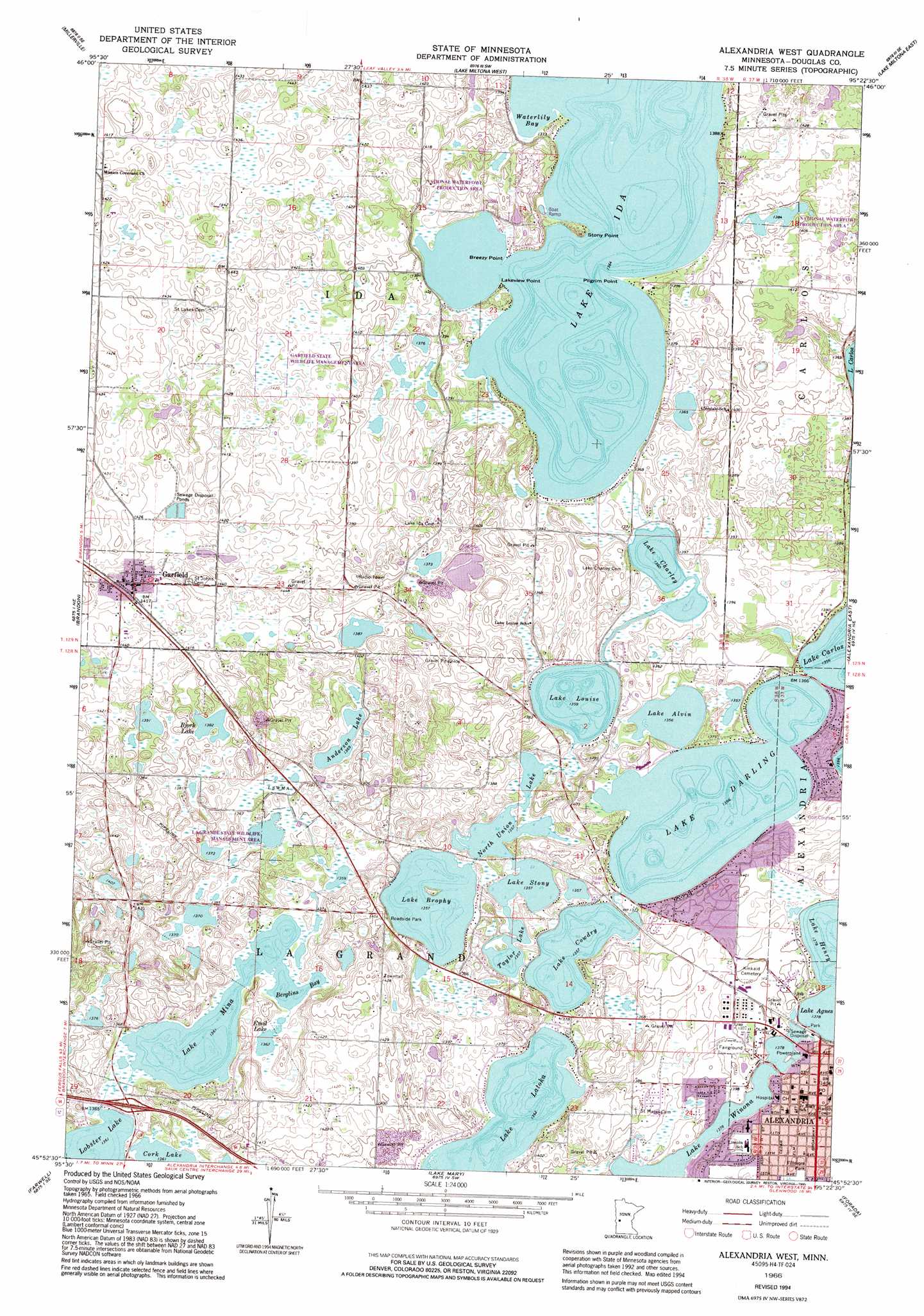
Alexandria West Topo Map Minnesota
To zoom in, hover over the map of Alexandria West
USGS Topo Quad 45095h4 - 1:24,000 scale
| Topo Map Name: | Alexandria West |
| USGS Topo Quad ID: | 45095h4 |
| Print Size: | ca. 21 1/4" wide x 27" high |
| Southeast Coordinates: | 45.875° N latitude / 95.375° W longitude |
| Map Center Coordinates: | 45.9375° N latitude / 95.4375° W longitude |
| U.S. State: | MN |
| Filename: | o45095h4.jpg |
| Download Map JPG Image: | Alexandria West topo map 1:24,000 scale |
| Map Type: | Topographic |
| Topo Series: | 7.5´ |
| Map Scale: | 1:24,000 |
| Source of Map Images: | United States Geological Survey (USGS) |
| Alternate Map Versions: |
Alexandria West MN 1966, updated 1967 Download PDF Buy paper map Alexandria West MN 1966, updated 1995 Download PDF Buy paper map Alexandria West MN 2010 Download PDF Buy paper map Alexandria West MN 2013 Download PDF Buy paper map Alexandria West MN 2016 Download PDF Buy paper map |
1:24,000 Topo Quads surrounding Alexandria West
Eagle Lake |
Inspiration Peak |
Parkers Prairie Nw |
Parkers Prairie |
Eagle Bend Nw |
Evansville |
Millerville |
Lake Miltona West |
Lake Miltona East |
Rose City |
Quam Lake |
Brandon |
Alexandria West |
Alexandria East |
Lake Osakis West |
Kensington |
Farwell |
Lake Mary |
Forada |
Osakis |
Starbuck Nw |
Lowry |
Glenwood |
Villard |
Westport |
> Back to 45095e1 at 1:100,000 scale
> Back to 45094a1 at 1:250,000 scale
> Back to U.S. Topo Maps home
Alexandria West topo map: Gazetteer
Alexandria West: Bays
Berglins Bay elevation 415m 1361′Waterlily Bay elevation 416m 1364′
Alexandria West: Capes
Breezy Point elevation 416m 1364′Lakeview Point elevation 416m 1364′
Pilgrim Point elevation 416m 1364′
Stony Point elevation 416m 1364′
Alexandria West: Crossings
Interchange 97 elevation 419m 1374′Alexandria West: Dams
Brophy Lake Dam elevation 415m 1361′Ida Lake Dam elevation 418m 1371′
Lobster Lake Dam elevation 418m 1371′
Louise Lake Dam elevation 415m 1361′
Alexandria West: Lakes
Anderson Lake elevation 417m 1368′Bjork Lake elevation 421m 1381′
Emil Lake elevation 415m 1361′
Lake Agnes elevation 420m 1377′
Lake Alvin elevation 414m 1358′
Lake Brophy elevation 414m 1358′
Lake Charley elevation 415m 1361′
Lake Cowdrey elevation 414m 1358′
Lake Darling elevation 414m 1358′
Lake Henry elevation 420m 1377′
Lake Ida elevation 416m 1364′
Lake Latoka elevation 415m 1361′
Lake Louise elevation 414m 1358′
Lake Mina elevation 415m 1361′
Lake Stony elevation 414m 1358′
Lake Winona elevation 420m 1377′
North Union Lake elevation 414m 1358′
Taylor Lake elevation 414m 1358′
Alexandria West: Parks
Goose Park elevation 425m 1394′LaGrand State Wildlife Management Area elevation 414m 1358′
Lake Brophy County Park elevation 427m 1400′
Pat Karnis Park elevation 420m 1377′
Tabberts Park elevation 424m 1391′
Three Havens County Park elevation 422m 1384′
Alexandria West: Populated Places
Alexandria elevation 428m 1404′Alexandria Mobile Estates elevation 428m 1404′
Don' Lakeview Mobile Home Park elevation 424m 1391′
Garfield elevation 433m 1420′
Woodlawn Mobile Home Court elevation 436m 1430′
Alexandria West: Post Offices
Alexandria Post Office elevation 427m 1400′Garfield Post Office elevation 433m 1420′
Alexandria West: Reservoirs
Brophy Lake elevation 415m 1361′Ida Lake elevation 418m 1371′
Lobster Lake elevation 418m 1371′
Louise Lake elevation 415m 1361′
Alexandria West digital topo map on disk
Buy this Alexandria West topo map showing relief, roads, GPS coordinates and other geographical features, as a high-resolution digital map file on DVD: