Nez Perce Peak Topo Map Idaho
To zoom in, hover over the map of Nez Perce Peak
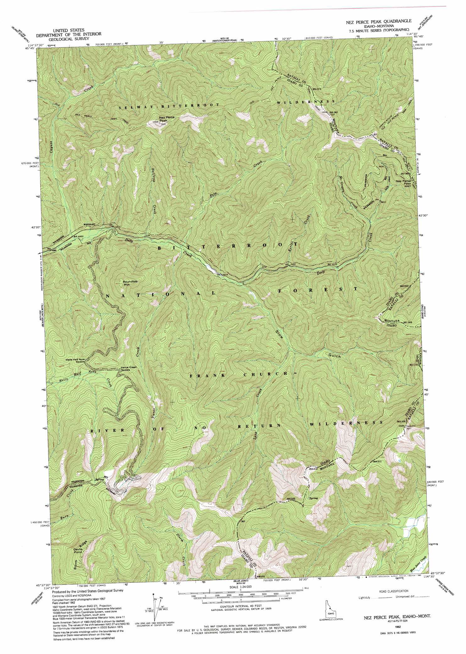
USGS Topo Quad 45114f5 - 1:24,000 scale
| Topo Map Name: | Nez Perce Peak |
| USGS Topo Quad ID: | 45114f5 |
| Print Size: | ca. 21 1/4" wide x 27" high |
| Southeast Coordinates: | 45.625° N latitude / 114.5° W longitude |
| Map Center Coordinates: | 45.6875° N latitude / 114.5625° W longitude |
| U.S. States: | ID, MT |
| Filename: | o45114f5.jpg |
| Download Map JPG Image: | Nez Perce Peak topo map 1:24,000 scale |
| Map Type: | Topographic |
| Topo Series: | 7.5´ |
| Map Scale: | 1:24,000 |
| Source of Map Images: | United States Geological Survey (USGS) |
| Alternate Map Versions: |
Nez Perce Peak ID 1962, updated 1964 Download PDF Buy paper map Nez Perce Peak ID 1962, updated 1980 Download PDF Buy paper map Nez Perce Peak ID 1962, updated 1993 Download PDF Buy paper map Nez Perce Peak ID 1998, updated 2002 Download PDF Buy paper map Nez Perce Peak ID 2011 Download PDF Buy paper map Nez Perce Peak ID 2013 Download PDF Buy paper map |
| FStopo: | US Forest Service topo Nez Perce Peak is available: Download FStopo PDF Download FStopo TIF |
1:24,000 Topo Quads surrounding Nez Perce Peak
Gardiner Peak |
Mount George |
Mount Paloma |
Tin Cup Lake |
Trapper Peak |
Spot Mountain |
Burnt Strip Mountain |
Watchtower Peak |
Mount Jerusalem |
Boulder Peak |
Magruder Mountain |
Beaver Jack Mountain |
Nez Perce Peak |
Bare Cone |
Painted Rocks Lake |
Stripe Mountain |
Wood Hump |
Blue Joint |
Horse Creek Pass |
Alta |
Waugh Mountain |
Square Top |
Horse Creek Butte |
Tincup Hill |
Shoup |
> Back to 45114e1 at 1:100,000 scale
> Back to 45114a1 at 1:250,000 scale
> Back to U.S. Topo Maps home
Nez Perce Peak topo map: Gazetteer
Nez Perce Peak: Flats
Blue Joint Meadows elevation 1949m 6394′Nez Perce Peak: Gaps
Hells Half Acre Saddle elevation 1929m 6328′Nez Perce Pass elevation 2004m 6574′
Nez Perce Pass elevation 1999m 6558′
Vance Creek Saddle elevation 1929m 6328′
Nez Perce Peak: Streams
Cayuse Creek elevation 1499m 4917′Halfway Creek elevation 1550m 5085′
Kerlee Creek elevation 1672m 5485′
Lazy Creek elevation 1643m 5390′
MacGregor Creek elevation 1724m 5656′
Magruder Creek elevation 1762m 5780′
Pete Creek elevation 1568m 5144′
Shumaker Creek elevation 1527m 5009′
Vance Creek elevation 1565m 5134′
Nez Perce Peak: Summits
Devils Point elevation 2497m 8192′Nez Perce Peak elevation 2297m 7536′
Roundtop Mountain elevation 2009m 6591′
Steep Hill elevation 2430m 7972′
Nez Perce Peak: Trails
Old Nez Perce Trail elevation 2155m 7070′Old Nez Perce Trail elevation 2188m 7178′
South Route Old Nez Perce Trail elevation 2087m 6847′
Nez Perce Peak: Valleys
Slow Gulch elevation 1592m 5223′Nez Perce Peak digital topo map on disk
Buy this Nez Perce Peak topo map showing relief, roads, GPS coordinates and other geographical features, as a high-resolution digital map file on DVD: