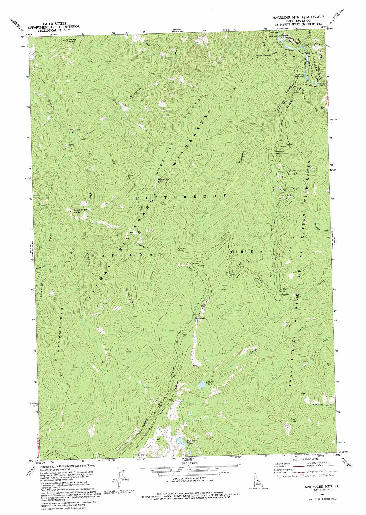
Magruder Mountain Topo Map Idaho
To zoom in, hover over the map of Magruder Mountain
USGS Topo Quad 45114f7 - 1:24,000 scale
| Topo Map Name: | Magruder Mountain |
| USGS Topo Quad ID: | 45114f7 |
| Print Size: | ca. 21 1/4" wide x 27" high |
| Southeast Coordinates: | 45.625° N latitude / 114.75° W longitude |
| Map Center Coordinates: | 45.6875° N latitude / 114.8125° W longitude |
| U.S. State: | ID |
| Filename: | o45114f7.jpg |
| Download Map JPG Image: | Magruder Mountain topo map 1:24,000 scale |
| Map Type: | Topographic |
| Topo Series: | 7.5´ |
| Map Scale: | 1:24,000 |
| Source of Map Images: | United States Geological Survey (USGS) |
| Alternate Map Versions: |
Magruder Mtn ID 1978, updated 1978 Download PDF Buy paper map Magruder Mountain ID 1991, updated 1995 Download PDF Buy paper map Magruder Mountain ID 1998, updated 2002 Download PDF Buy paper map Magruder Mountain ID 2011 Download PDF Buy paper map Magruder Mountain ID 2013 Download PDF Buy paper map |
| FStopo: | US Forest Service topo Magruder Mountain is available: Download FStopo PDF Download FStopo TIF |
1:24,000 Topo Quads surrounding Magruder Mountain
Running Lake |
Wylies Peak |
Gardiner Peak |
Mount George |
Mount Paloma |
Green Mountain |
Three Prong Mountain |
Spot Mountain |
Burnt Strip Mountain |
Watchtower Peak |
Spread Creek Point |
Sabe Mountain |
Magruder Mountain |
Beaver Jack Mountain |
Nez Perce Peak |
Sheep Hill |
Dennis Mountain |
Stripe Mountain |
Wood Hump |
Blue Joint |
Arctic Point |
Devils Teeth Rapids |
Waugh Mountain |
Square Top |
Horse Creek Butte |
> Back to 45114e1 at 1:100,000 scale
> Back to 45114a1 at 1:250,000 scale
> Back to U.S. Topo Maps home
Magruder Mountain topo map: Gazetteer
Magruder Mountain: Capes
Beaver Point elevation 1127m 3697′Magruder Mountain: Crossings
Magruder Crossing elevation 1132m 3713′Magruder Mountain: Gaps
Haystack Saddle elevation 1478m 4849′Kim Creek Saddle elevation 1776m 5826′
Magruder Saddle elevation 2105m 6906′
Magruder Mountain: Lakes
Elk Track Lakes elevation 2325m 7627′Gold Pan Lake elevation 2232m 7322′
Magruder Mountain: Ridges
Magruder Ridge elevation 2160m 7086′Salamander Ridge elevation 2033m 6669′
Magruder Mountain: Streams
Chuckling Creek elevation 1578m 5177′East Fork Magruder Creek elevation 1389m 4557′
Ely Creek elevation 1492m 4895′
Flat Creek elevation 1463m 4799′
Lodge Creek elevation 1527m 5009′
Lonely Creek elevation 1461m 4793′
Lost Elk Creek elevation 1463m 4799′
Nick Creek elevation 1130m 3707′
Salamander Creek elevation 1467m 4812′
Short Creek elevation 1287m 4222′
Snow Water Creek elevation 1652m 5419′
Magruder Mountain: Summits
Deadtop Mountain elevation 2382m 7814′Lonely Mountain elevation 2054m 6738′
Magruder Mountain elevation 2257m 7404′
Salamander Butte elevation 1840m 6036′
Magruder Mountain: Valleys
Steep Gulch elevation 1143m 3750′Magruder Mountain digital topo map on disk
Buy this Magruder Mountain topo map showing relief, roads, GPS coordinates and other geographical features, as a high-resolution digital map file on DVD: