Ives Hill Topo Map Michigan
To zoom in, hover over the map of Ives Hill
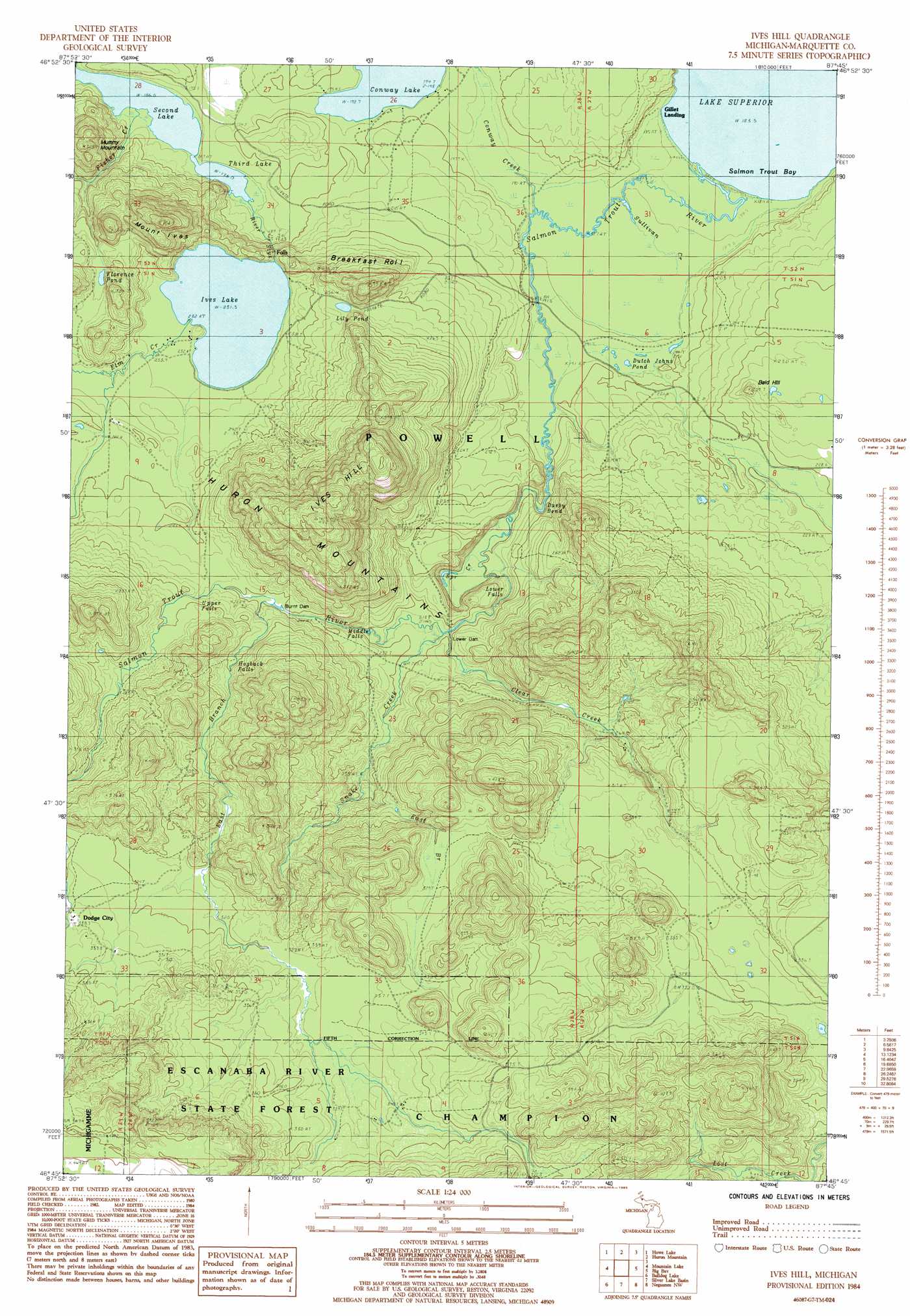
USGS Topo Quad 46087g7 - 1:24,000 scale
| Topo Map Name: | Ives Hill |
| USGS Topo Quad ID: | 46087g7 |
| Print Size: | ca. 21 1/4" wide x 27" high |
| Southeast Coordinates: | 46.75° N latitude / 87.75° W longitude |
| Map Center Coordinates: | 46.8125° N latitude / 87.8125° W longitude |
| U.S. State: | MI |
| Filename: | o46087g7.jpg |
| Download Map JPG Image: | Ives Hill topo map 1:24,000 scale |
| Map Type: | Topographic |
| Topo Series: | 7.5´ |
| Map Scale: | 1:24,000 |
| Source of Map Images: | United States Geological Survey (USGS) |
| Alternate Map Versions: |
Ives Hill MI 1984, updated 1985 Download PDF Buy paper map Ives Hill MI 1984, updated 1985 Download PDF Buy paper map Ives Hill MI 2011 Download PDF Buy paper map Ives Hill MI 2014 Download PDF Buy paper map Ives Hill MI 2017 Download PDF Buy paper map |
1:24,000 Topo Quads surrounding Ives Hill
Glovers Corner |
Howe Lake |
Huron Mountain |
||
Mccomb Corner |
Mountain Lake |
Ives Hill |
Big Bay |
Granite Point |
Summit Lake |
Bulldog Lake |
Silver Lake Basin |
Negaunee Nw |
Buckroe |
Michigamme |
Champion |
Diorite |
Negaunee Sw |
Negaunee |
> Back to 46087e1 at 1:100,000 scale
> Back to 46086a1 at 1:250,000 scale
> Back to U.S. Topo Maps home
Ives Hill topo map: Gazetteer
Ives Hill: Bays
Salmon Trout Bay elevation 183m 600′Ives Hill: Bends
Darby Bend elevation 202m 662′Ives Hill: Dams
Burnt Dam elevation 246m 807′Lower Dam elevation 220m 721′
Ives Hill: Falls
Eighty Foot Falls elevation 219m 718′Hogback Falls elevation 270m 885′
Lower Falls elevation 203m 666′
Middle Falls elevation 219m 718′
Upper Falls elevation 259m 849′
Ives Hill: Guts
Conway Creek elevation 193m 633′Ives Hill: Lakes
Dutch Johns Pond elevation 193m 633′Florence Pond elevation 251m 823′
Ives Lake elevation 231m 757′
Lily Pond elevation 258m 846′
Second Lake elevation 186m 610′
Third Lake elevation 186m 610′
Ives Hill: Populated Places
Dodge City elevation 338m 1108′Gillet Landing elevation 185m 606′
Ives Hill: Ranges
Huron Mountains elevation 389m 1276′Ives Hill: Streams
Clear Creek elevation 218m 715′East Branch Salmon Trout River elevation 246m 807′
East Branch Snake Creek elevation 233m 764′
Elm Creek elevation 232m 761′
Fisher Creek elevation 188m 616′
River Styx elevation 186m 610′
Salmon Trout River elevation 184m 603′
Snake Creek elevation 218m 715′
Spring Creek elevation 196m 643′
Sullivan Creek elevation 185m 606′
Ives Hill: Summits
Bald Hill elevation 257m 843′Breakfast Roll elevation 354m 1161′
Ives Hill elevation 460m 1509′
Mount Ives elevation 399m 1309′
Ives Hill digital topo map on disk
Buy this Ives Hill topo map showing relief, roads, GPS coordinates and other geographical features, as a high-resolution digital map file on DVD: