Summit Lake Topo Map Michigan
To zoom in, hover over the map of Summit Lake
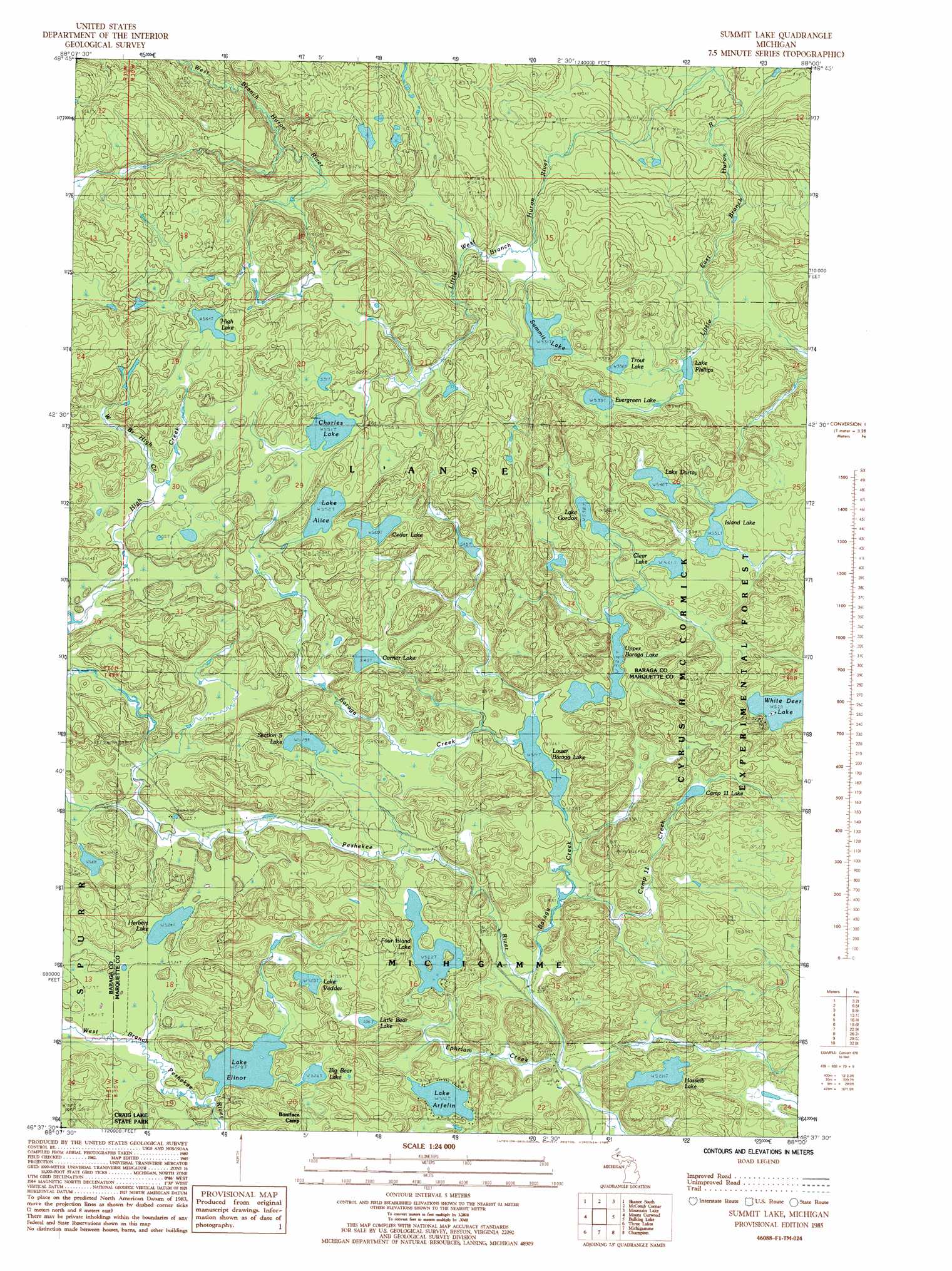
USGS Topo Quad 46088f1 - 1:24,000 scale
| Topo Map Name: | Summit Lake |
| USGS Topo Quad ID: | 46088f1 |
| Print Size: | ca. 21 1/4" wide x 27" high |
| Southeast Coordinates: | 46.625° N latitude / 88° W longitude |
| Map Center Coordinates: | 46.6875° N latitude / 88.0625° W longitude |
| U.S. State: | MI |
| Filename: | o46088f1.jpg |
| Download Map JPG Image: | Summit Lake topo map 1:24,000 scale |
| Map Type: | Topographic |
| Topo Series: | 7.5´ |
| Map Scale: | 1:24,000 |
| Source of Map Images: | United States Geological Survey (USGS) |
| Alternate Map Versions: |
Summit Lake MI 1985, updated 1985 Download PDF Buy paper map Summit Lake MI 1985, updated 1985 Download PDF Buy paper map Summit Lake MI 1999, updated 2004 Download PDF Buy paper map Summit Lake MI 2011 Download PDF Buy paper map Summit Lake MI 2014 Download PDF Buy paper map Summit Lake MI 2016 Download PDF Buy paper map |
| FStopo: | US Forest Service topo Summit Lake is available: Download FStopo PDF Download FStopo TIF |
1:24,000 Topo Quads surrounding Summit Lake
Keweenaw Bay Ne |
Skanee North |
Glovers Corner |
Howe Lake |
Huron Mountain |
Aura |
Skanee South |
Mccomb Corner |
Mountain Lake |
Ives Hill |
Herman |
Mount Curwood |
Summit Lake |
Bulldog Lake |
Silver Lake Basin |
Nestoria |
Three Lakes |
Michigamme |
Champion |
Diorite |
Ned Lake |
Nelson Lake |
Witch Lake Ne |
Republic |
Greenwood |
> Back to 46088e1 at 1:100,000 scale
> Back to 46088a1 at 1:250,000 scale
> Back to U.S. Topo Maps home
Summit Lake topo map: Gazetteer
Summit Lake: Lakes
Big Bear Lake elevation 526m 1725′Camp Eleven Lake elevation 543m 1781′
Cedar Lake elevation 559m 1833′
Charles Lake elevation 551m 1807′
Clear Lake elevation 531m 1742′
Corner Lake elevation 543m 1781′
Evergreen Lake elevation 539m 1768′
Four Island Lake elevation 522m 1712′
Hasseib Lake elevation 528m 1732′
Hebert Lake elevation 524m 1719′
High Lake elevation 564m 1850′
Island Lake elevation 532m 1745′
Lake Alice elevation 552m 1811′
Lake Arfelin elevation 512m 1679′
Lake Dortay elevation 540m 1771′
Lake Elinor elevation 519m 1702′
Lake Gordon elevation 538m 1765′
Lake Phillips elevation 533m 1748′
Lake Vedder elevation 529m 1735′
Little Bear Lake elevation 536m 1758′
Lower Baraga Lake elevation 521m 1709′
Section Five Lake elevation 529m 1735′
Summit Lake elevation 531m 1742′
Trout Lake elevation 536m 1758′
Upper Baraga Lake elevation 522m 1712′
White Deer Lake elevation 527m 1729′
Summit Lake: Parks
Sawyer Lake County Park elevation 537m 1761′Summit Lake: Streams
Baraga Creek elevation 508m 1666′Camp Eleven Creek elevation 519m 1702′
Ephriam Creek elevation 505m 1656′
Little East Branch Huron River elevation 444m 1456′
Little West Branch Huron River elevation 444m 1456′
Summit Lake: Trails
Upper Baraga Lake Trail elevation 525m 1722′White Deer Lake Trail elevation 564m 1850′
Summit Lake digital topo map on disk
Buy this Summit Lake topo map showing relief, roads, GPS coordinates and other geographical features, as a high-resolution digital map file on DVD: