Little Girls Point Topo Map Michigan
To zoom in, hover over the map of Little Girls Point
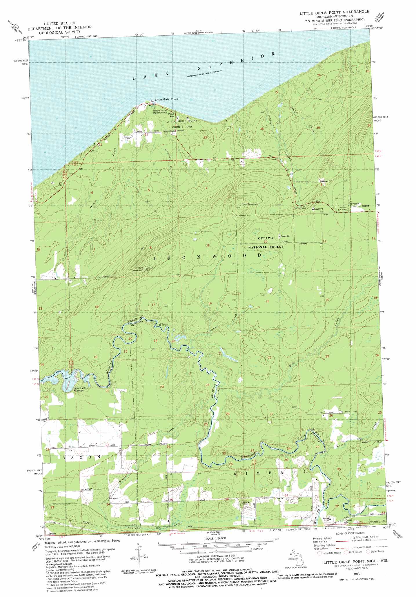
USGS Topo Quad 46090e3 - 1:24,000 scale
| Topo Map Name: | Little Girls Point |
| USGS Topo Quad ID: | 46090e3 |
| Print Size: | ca. 21 1/4" wide x 27" high |
| Southeast Coordinates: | 46.5° N latitude / 90.25° W longitude |
| Map Center Coordinates: | 46.5625° N latitude / 90.3125° W longitude |
| U.S. States: | MI, WI |
| Filename: | o46090e3.jpg |
| Download Map JPG Image: | Little Girls Point topo map 1:24,000 scale |
| Map Type: | Topographic |
| Topo Series: | 7.5´ |
| Map Scale: | 1:24,000 |
| Source of Map Images: | United States Geological Survey (USGS) |
| Alternate Map Versions: |
Little Girls Point MI 1943 Download PDF Buy paper map Little Girls Point MI 1980, updated 1981 Download PDF Buy paper map Little Girls Point MI 2011 Download PDF Buy paper map Little Girls Point MI 2014 Download PDF Buy paper map Little Girls Point MI 2016 Download PDF Buy paper map |
| FStopo: | US Forest Service topo Little Girls Point is available: Download FStopo PDF Download FStopo TIF |
1:24,000 Topo Quads surrounding Little Girls Point
Amnicon Point |
||||
Black River Harbor |
||||
Cedar |
Oronto Bay |
Little Girls Point |
Copper Peak |
|
Gurney |
Saxon |
Iron Belt |
Ironwood |
Bessemer |
Mount Whittlesey |
Upson |
Turntable Creek |
Pine Lake |
Lake Evelyn |
> Back to 46090e1 at 1:100,000 scale
> Back to 46090a1 at 1:250,000 scale
> Back to U.S. Topo Maps home
Little Girls Point topo map: Gazetteer
Little Girls Point: Capes
Little Girls Point elevation 187m 613′Little Girls Point: Parks
Lake Superior Park elevation 209m 685′Little Girls Point County Park elevation 197m 646′
Little Girls Point: Reservoirs
Saxon Falls Flowage elevation 301m 987′Saxon Falls Flowage elevation 299m 980′
Little Girls Point: Streams
Boomer Creek elevation 314m 1030′Burton Creek elevation 308m 1010′
Collins Creek elevation 310m 1017′
Flood Creek elevation 346m 1135′
Fourche Creek elevation 339m 1112′
Ikwesens Creek elevation 184m 603′
Killdeer Creek elevation 183m 600′
Moore Creek elevation 337m 1105′
Mud Creek elevation 313m 1026′
Omans Creek elevation 184m 603′
Scalp Creek elevation 191m 626′
Viking Creek elevation 186m 610′
West Fork Montreal River elevation 342m 1122′
Little Girls Point: Summits
Bald Mountain elevation 399m 1309′Point Mountain elevation 381m 1250′
Little Girls Point digital topo map on disk
Buy this Little Girls Point topo map showing relief, roads, GPS coordinates and other geographical features, as a high-resolution digital map file on DVD: