Pinkham Butte Topo Map Washington
To zoom in, hover over the map of Pinkham Butte
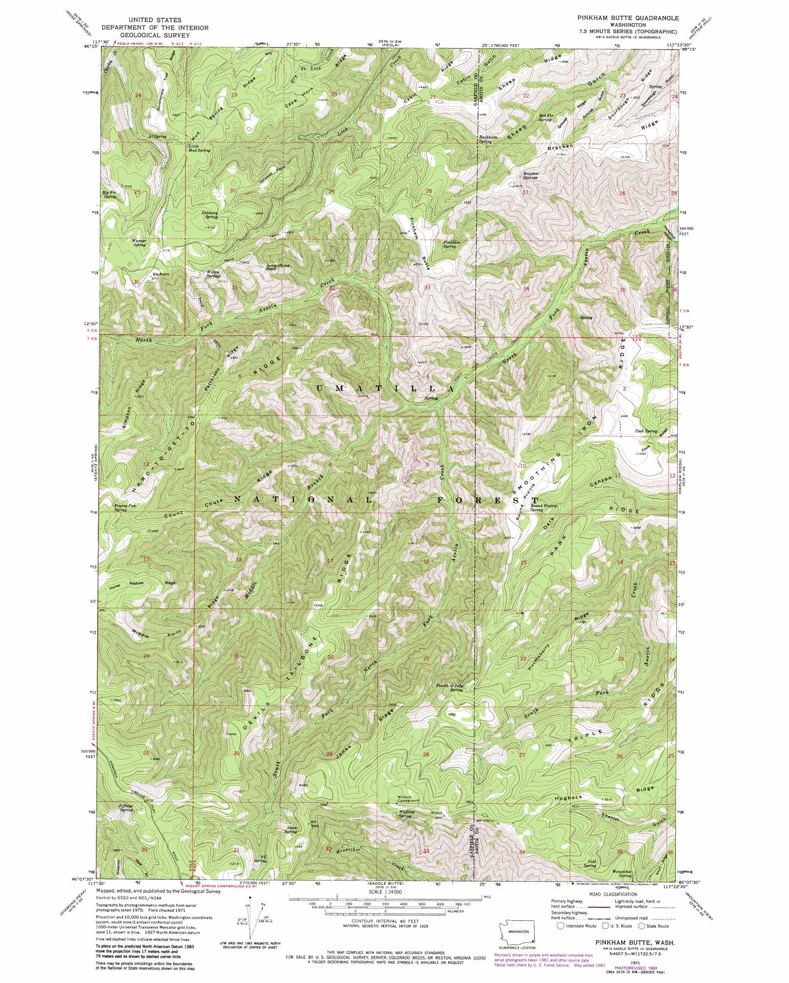
USGS Topo Quad 46117b4 - 1:24,000 scale
| Topo Map Name: | Pinkham Butte |
| USGS Topo Quad ID: | 46117b4 |
| Print Size: | ca. 21 1/4" wide x 27" high |
| Southeast Coordinates: | 46.125° N latitude / 117.375° W longitude |
| Map Center Coordinates: | 46.1875° N latitude / 117.4375° W longitude |
| U.S. State: | WA |
| Filename: | o46117b4.jpg |
| Download Map JPG Image: | Pinkham Butte topo map 1:24,000 scale |
| Map Type: | Topographic |
| Topo Series: | 7.5´ |
| Map Scale: | 1:24,000 |
| Source of Map Images: | United States Geological Survey (USGS) |
| Alternate Map Versions: |
Pinkham Butte WA 1971, updated 1974 Download PDF Buy paper map Pinkham Butte WA 1971, updated 1983 Download PDF Buy paper map Pinkham Butte WA 1995, updated 1998 Download PDF Buy paper map Pinkham Butte WA 2011 Download PDF Buy paper map Pinkham Butte WA 2014 Download PDF Buy paper map |
| FStopo: | US Forest Service topo Pinkham Butte is available: Download FStopo PDF Download FStopo TIF |
1:24,000 Topo Quads surrounding Pinkham Butte
Zumwalt |
Pomeroy |
Alpowa Ridge |
Stember Creek |
Silcott Island |
Hopkins Ridge |
Rose Springs |
Peola |
Potter Hill |
Rockpile Creek |
Panjab Creek |
Stentz Spring |
Pinkham Butte |
Harlow Ridge |
Anatone |
Oregon Butte |
Diamond Peak |
Saddle Butte |
Mountain View |
Fields Spring |
Elbow Creek |
Eden |
Troy |
Flora |
Paradise |
> Back to 46117a1 at 1:100,000 scale
> Back to 46116a1 at 1:250,000 scale
> Back to U.S. Topo Maps home
Pinkham Butte topo map: Gazetteer
Pinkham Butte: Capes
Getaway Point elevation 1469m 4819′Pinkham Butte: Cliffs
Jump Off Joe Point elevation 1436m 4711′Pinkham Butte: Flats
Round Prairie elevation 1482m 4862′Pinkham Butte: Ridges
Cabin Ridge elevation 1344m 4409′Count Chute Ridge elevation 1375m 4511′
Devils Tailbone Ridge elevation 1694m 5557′
Government Trail Ridge elevation 1454m 4770′
Grouse Ridge elevation 1183m 3881′
Hard-to-get-to Ridge elevation 1625m 5331′
Horse Pasture Ridge elevation 1810m 5938′
Huckleberry Ridge elevation 1540m 5052′
Jones Ridge elevation 1713m 5620′
Middle Point Ridge elevation 1603m 5259′
Mud Spring Ridge elevation 1468m 4816′
Patterson Ridge elevation 1492m 4895′
Pinkham Ridge elevation 1317m 4320′
Sheep Ridge elevation 1214m 3982′
Simpson Ridge elevation 1628m 5341′
Triple Ridge elevation 1572m 5157′
Pinkham Butte: Springs
Al Spring elevation 1455m 4773′Big Fir Spring elevation 1498m 4914′
Bracken Springs elevation 1265m 4150′
Buckhorn Spring elevation 1214m 3982′
Cold Spring elevation 1648m 5406′
Cook Spring elevation 1361m 4465′
Fourth of July Spring elevation 1664m 5459′
Frying Pan Spring elevation 1776m 5826′
Getaway Spring elevation 1520m 4986′
Jeffreys Spring elevation 1829m 6000′
Little Mud Spring elevation 1489m 4885′
Pinkham Spring elevation 1343m 4406′
Red Fir Spring elevation 1106m 3628′
Round Prairie Spring elevation 1491m 4891′
Snow Spring elevation 1759m 5770′
Three C Spring elevation 1790m 5872′
Warner Spring elevation 1534m 5032′
Wenatchee Spring elevation 1639m 5377′
Wickiup Spring elevation 1795m 5889′
Willow Springs elevation 1470m 4822′
Pinkham Butte: Streams
Middle Branch North Fork Asotin Creek elevation 950m 3116′South Fork North Fork Asotin Creek elevation 953m 3126′
Pinkham Butte: Summits
Elk Point elevation 1602m 5255′Pinkham Butte elevation 1441m 4727′
Pinkham Butte: Trails
North Fork Asotin Creek Trail elevation 951m 3120′Pinkham Butte: Valleys
Grouse Gulch elevation 1016m 3333′Horsethief Canyon elevation 809m 2654′
Pinkham Butte digital topo map on disk
Buy this Pinkham Butte topo map showing relief, roads, GPS coordinates and other geographical features, as a high-resolution digital map file on DVD: