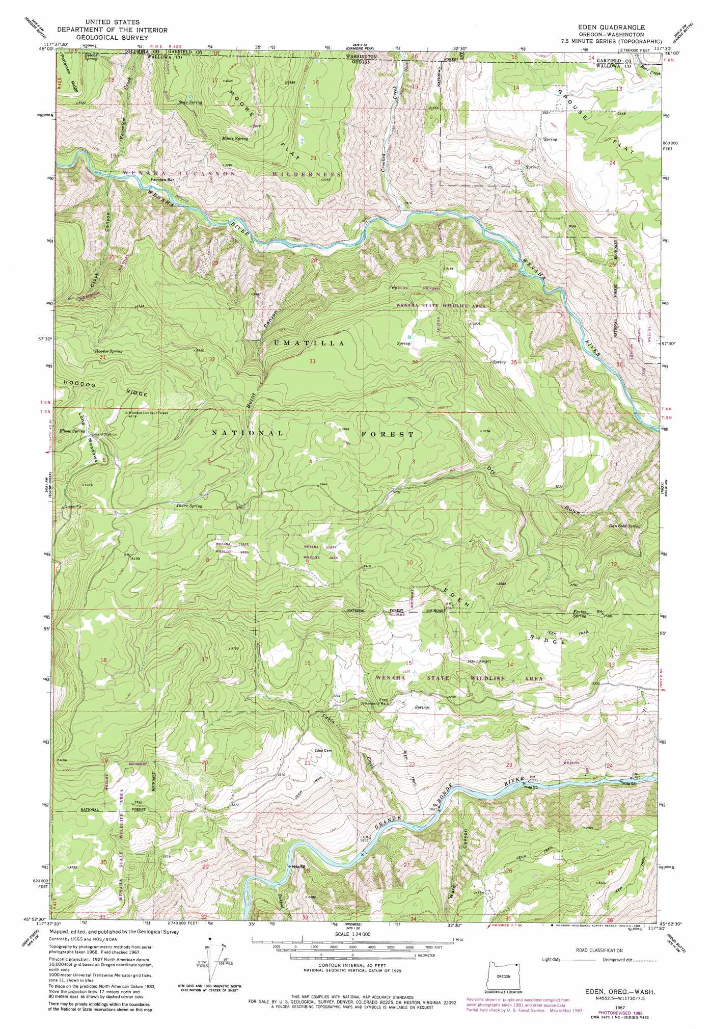
Eden Topo Map Oregon
To zoom in, hover over the map of Eden
USGS Topo Quad 45117h5 - 1:24,000 scale
| Topo Map Name: | Eden |
| USGS Topo Quad ID: | 45117h5 |
| Print Size: | ca. 21 1/4" wide x 27" high |
| Southeast Coordinates: | 45.875° N latitude / 117.5° W longitude |
| Map Center Coordinates: | 45.9375° N latitude / 117.5625° W longitude |
| U.S. States: | OR, WA |
| Filename: | o45117h5.jpg |
| Download Map JPG Image: | Eden topo map 1:24,000 scale |
| Map Type: | Topographic |
| Topo Series: | 7.5´ |
| Map Scale: | 1:24,000 |
| Source of Map Images: | United States Geological Survey (USGS) |
| Alternate Map Versions: |
Eden OR 1967, updated 1971 Download PDF Buy paper map Eden OR 1967, updated 1984 Download PDF Buy paper map Eden OR 1995, updated 1998 Download PDF Buy paper map Eden Ridge OR 2011 Download PDF Buy paper map Eden Ridge OR 2014 Download PDF Buy paper map |
| FStopo: | US Forest Service topo Eden Ridge is available: Download FStopo PDF Download FStopo TIF |
1:24,000 Topo Quads surrounding Eden
Eckler Mountain |
Panjab Creek |
Stentz Spring |
Pinkham Butte |
Harlow Ridge |
Godman Spring |
Oregon Butte |
Diamond Peak |
Saddle Butte |
Mountain View |
Wenaha Forks |
Elbow Creek |
Eden |
Troy |
Flora |
Fry Meadow |
Deep Creek |
Promise |
Wood Butte |
Shamrock Creek |
Rondowa |
Howard Butte |
Akers Butte |
Washboard Ridge |
Sled Springs |
> Back to 45117e1 at 1:100,000 scale
> Back to 45116a1 at 1:250,000 scale
> Back to U.S. Topo Maps home
Eden topo map: Gazetteer
Eden: Bars
Fairview Bar elevation 631m 2070′Eden: Flats
Long Meadows elevation 1214m 3982′Moore Flat elevation 1112m 3648′
Moore Flat elevation 1116m 3661′
Eden: Populated Places
Eden elevation 984m 3228′Eden: Post Offices
Eden Post Office (historical) elevation 984m 3228′Eden: Ridges
Eden Ridge elevation 1131m 3710′Eden: Springs
Bobcat Spring elevation 1047m 3435′Cummings Spring elevation 1217m 3992′
Dan Cold Spring elevation 944m 3097′
Elbow Spring elevation 1216m 3989′
Fenton Spring elevation 1096m 3595′
Hoodoo Spring elevation 1186m 3891′
Moore Spring elevation 1072m 3517′
Soap Spring elevation 1072m 3517′
Thorn Spring elevation 1240m 4068′
Eden: Streams
Cabin Creek elevation 547m 1794′Crooked Creek elevation 575m 1886′
Crooked Creek elevation 581m 1906′
Fairview Creek elevation 638m 2093′
Fairview Creek elevation 635m 2083′
Sickfoot Creek elevation 558m 1830′
Eden: Valleys
Burnt Canyon elevation 598m 1961′Cross Canyon elevation 644m 2112′
Ward Canyon elevation 543m 1781′
Eden digital topo map on disk
Buy this Eden topo map showing relief, roads, GPS coordinates and other geographical features, as a high-resolution digital map file on DVD: