Grayland Topo Map Washington
To zoom in, hover over the map of Grayland
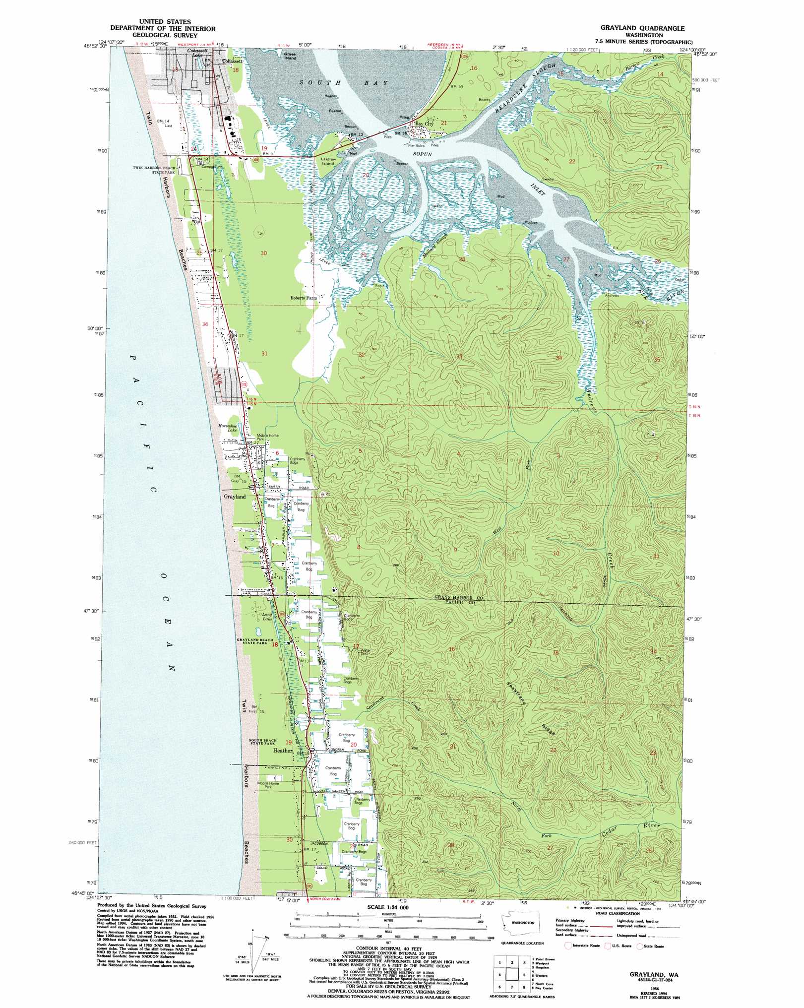
USGS Topo Quad 46124g1 - 1:24,000 scale
| Topo Map Name: | Grayland |
| USGS Topo Quad ID: | 46124g1 |
| Print Size: | ca. 21 1/4" wide x 27" high |
| Southeast Coordinates: | 46.75° N latitude / 124° W longitude |
| Map Center Coordinates: | 46.8125° N latitude / 124.0625° W longitude |
| U.S. State: | WA |
| Filename: | o46124g1.jpg |
| Download Map JPG Image: | Grayland topo map 1:24,000 scale |
| Map Type: | Topographic |
| Topo Series: | 7.5´ |
| Map Scale: | 1:24,000 |
| Source of Map Images: | United States Geological Survey (USGS) |
| Alternate Map Versions: |
Grayland WA 1956, updated 1959 Download PDF Buy paper map Grayland WA 1956, updated 1977 Download PDF Buy paper map Grayland WA 1956, updated 1985 Download PDF Buy paper map Grayland WA 1956, updated 1995 Download PDF Buy paper map Grayland WA 2011 Download PDF Buy paper map Grayland WA 2014 Download PDF Buy paper map |
1:24,000 Topo Quads surrounding Grayland
Copalis Beach |
Copalis Crossing |
New London |
Aberdeen Gardens |
|
Point Brown |
Westport |
Hoquiam |
Aberdeen |
|
Grayland |
Western |
Aberdeen Se |
||
North Cove |
Bay Center |
South Bend |
||
Oysterville |
Nemah |
North Nemah |
> Back to 46124e1 at 1:100,000 scale
> Back to 46124a1 at 1:250,000 scale
> Back to U.S. Topo Maps home
Grayland topo map: Gazetteer
Grayland: Areas
Twin Harbors Beaches elevation 8m 26′Grayland: Bays
Sopun Inlet elevation 0m 0′Grayland: Canals
Drainage Ditch Number 1 elevation 9m 29′Grayland: Islands
Laidlaw Island elevation 8m 26′Grayland: Lakes
Cohassett Lake elevation 7m 22′Horseshoe Lake elevation 8m 26′
Long Lake elevation 8m 26′
Grayland: Parks
Grayland Access State Park elevation 7m 22′Grayland Beach State Park elevation 6m 19′
South Beach State Park elevation 5m 16′
Twin Harbors Beach State Park elevation 8m 26′
Grayland: Populated Places
Bay City elevation 7m 22′Cohassett elevation 7m 22′
Cohassett Beach elevation 8m 26′
Grayland elevation 8m 26′
Heather elevation 8m 26′
Laidlow elevation 8m 26′
Grayland: Ridges
Seastrand Ridge elevation 138m 452′Grayland: Streams
Andrews Creek elevation 0m 0′Barlow Creek elevation 4m 13′
Beardslee Slough elevation 0m 0′
Dempsey Creek elevation 9m 29′
Elk River elevation 0m 0′
Mallard Slough elevation 0m 0′
North Fork Cedar River elevation 8m 26′
Seastrand Creek elevation 8m 26′
West Fork Andrews Creek elevation 10m 32′
Grayland digital topo map on disk
Buy this Grayland topo map showing relief, roads, GPS coordinates and other geographical features, as a high-resolution digital map file on DVD: